Minamisanriku
Miki Endo was twenty-four years old and working in the Crisis Management Department when the ground began to shake on March 11, 2011. As a wall of seawater taller than a four-story building bore down on Minamisanriku, she stayed at her microphone inside the town's three-story crisis management building, broadcasting warnings over the community loudspeaker system. "Please evacuate to higher ground," she repeated, again and again, as colleagues fled to the roof. The water swallowed the building to its antenna. Of the roughly forty people who reached the rooftop, only eleven survived by clinging to the antenna structure. Miki Endo was not among them. Her voice, Japanese media later reported, saved thousands of lives. Today the gutted red steel skeleton of that building stands preserved in Minamisanriku's memorial park -- a monument to one woman's refusal to stop speaking when silence would have been easier.
A Thousand Years of Waves
Minamisanriku sits on the jagged Sanriku coast of Miyagi Prefecture, where steep-sided rias funnel incoming waves to devastating heights. The town has known tsunamis since the recorded 869 Sanriku earthquake. The 1896 Sanriku earthquake generated what was then the highest tsunami wave ever documented in Japan. The 1933 Sanriku earthquake struck again. When the 1960 Valdivia earthquake in Chile -- the most powerful earthquake ever recorded -- sent a tsunami racing across the entire Pacific Ocean, it hit the town of Shizugawa, one of Minamisanriku's predecessor communities, with waves causing extensive damage and killing 142 people along the nearby coast. In response, two-story-high harbor walls were built by 1963. Residents conducted annual tsunami drills on the anniversary. They believed they were prepared.
The Day the Walls Failed
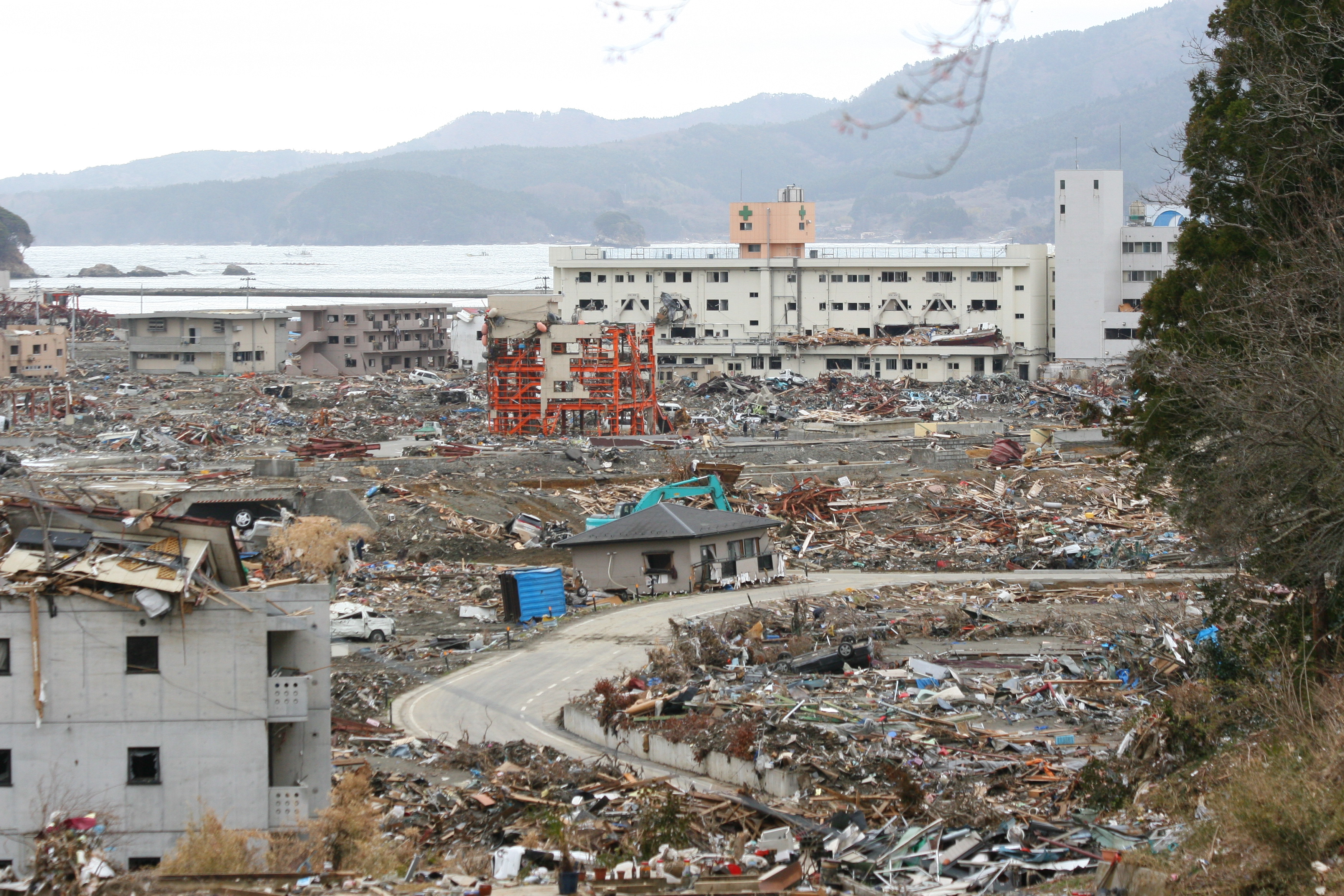
On March 11, 2011, the magnitude 9.0 Tohoku earthquake struck at 2:46 PM. The harbor walls, designed for a previous century's understanding of risk, proved useless. The tsunami washed over four-story buildings. Ninety-five percent of the town was destroyed. In the chaotic first week, only 9,700 of the town's approximately 17,000 residents were confirmed alive and evacuated. By late June, 1,206 people were counted as dead or missing. At least 31 of the town's 80 designated evacuation sites were inundated -- including two major centers positioned twenty meters above sea level that residents had been told were safe. An English teacher at the high school on the hill above described looking down: "The entire town was simply swept away. It just no longer exists." Survivors wrote "SOS" in white lettering across the playing field of Shizugawa High School.
Ten Who Lived, One Hundred Twenty Who Did Not
Mayor Jin Sato had been speaking to the town assembly about the smaller tsunami from a March 9 foreshock when the main earthquake hit. He escaped to the roof of the town hall building as the water rose. Of the 130 people who worked in that building, 53 reached the roof. Only 10 survived. Sato was among them. Two days later, on March 13, he resumed government operations from the Bayside Arena, establishing a disaster control headquarters. The fishing fleet -- the economic heart of this coastal community -- was largely destroyed or swept away. But fishermen pooled what remained, sharing boats and supplies to restart their industry. The town's seafood market, one of the first amenities to reopen, initially operated from a large tent before being properly rebuilt.
The Moai Across the Pacific
In 1990, thirty years after the Chilean tsunami devastated Shizugawa, a bilingual Spanish-Japanese plaque was installed with a message from Chilean President Patricio Aylwin, accompanied by a replica moai statue -- the iconic stone figures of Easter Island. It was a gesture of solidarity between two nations linked by the Pacific Ocean's capacity for destruction. The 2011 tsunami destroyed the replica. But the connection held. Chilean President Sebastian Pinera visited Minamisanriku in March 2012 and promised a replacement. In May 2013, a new moai arrived: three meters tall, two tons, carved from genuine Easter Island stone. It is the only moai carved from island rock that has ever been permitted to leave. The statue stands today as a symbol of reconstruction and of a friendship forged by shared catastrophe, proof that solidarity can travel as far as a tsunami wave.
The Skeleton That Speaks
The red steel frame of the Crisis Management Department building has been preserved as the centerpiece of Minamisanriku's Earthquake Disaster Memorial Park. Its bent beams and empty floors testify to the force that gutted a three-story concrete structure down to its bones. Above the park, an observation deck overlooks the coast and the ongoing reconstruction. Plaques along the climb mark the height the tsunami reached, so visitors feel the water's progress with every step upward. A new sea wall has been constructed. The town, which peaked in population in the 1950s and had been declining for decades before the disaster, continues to rebuild -- smaller, more cautious, but still oriented toward the sea that has defined and devastated it for a millennium.
From the Air
Located at 38.68N, 141.46E on the deeply indented Sanriku rias coast of Miyagi Prefecture. The town occupies a narrow coastal plain surrounded by steep forested hills. The red steel skeleton of the Crisis Management building may be visible from low altitude. The rias coastline with its deep inlets and headlands is a striking visual feature. Nearest major airport: Sendai Airport (RJSS) approximately 70nm south-southwest. The Kesennuma Line railway (now BRT bus service) follows the coast. Neighboring cities Ishinomaki and Kesennuma provide additional reference. Expect sea fog and marine layer conditions common to the Sanriku coast, particularly in spring and early summer.