Minsener Oog
Most islands are accidents of geology. Minsener Oog is on purpose. In 1906 the Wilhelmshaven Marine Construction Authority began building groynes and embankments across a pair of low sandbanks in the outer Jade estuary, with one goal: keep the navigation channel to Germany's main naval base from silting shut. Sand piled against the new structures. Beach grass took hold. Birds arrived. By the 1970s the engineers had returned with dredgers and dumped roughly 10 million cubic meters of channel spoil onto the bank, building dunes 12 meters high. The result is an island - roughly 4.5 kilometers long, up to 1.5 kilometers wide - that exists because human beings needed somewhere for sand to stop moving.
The Seewiefken of Minsen
The name comes from the mainland village of Minsen, four kilometers south across the Wadden Sea. There is an old story attached. According to local legend, Minsen was originally a village on the island itself. The fishermen one day caught a mermaid with the lower body of a fish, and refused to release her. In revenge, she summoned a flood that drowned the village, and the survivors rebuilt on the mainland. A bronze sculpture of the Minsen Seewiefken - the Minsen sea-woman - stands in the village today, and her image is on the coat of arms of the Wangerland parish. Whether one believes the legend literally or not, the East Frisian coast has been redrawn enough times by storm surges that the story carries a weight beyond its supernatural details.
Sand With a Purpose
In 1906 the engineers laid the first groynes on a sandbank called the Olde Oog, just south of the older Minsener Oog bank. The principle was straightforward. Long rock fingers reaching out from the bank would slow the eastward drift of sand and force it to settle on the upstream side. Fore-dunes built up. Beach grass colonized them. Seabirds discovered an undisturbed nesting site and began breeding by the thousand. The original goal was strictly naval: a clear, deep channel through the Jade to keep the Imperial German Navy's anchorage at Wilhelmshaven accessible. The engineers got their channel. The birds got their island. Originally the plan was to extend the works north and physically connect Minsener Oog to Wangerooge, halting that island's eastward drift. The 1930s revived the project briefly; the Second World War ended it.
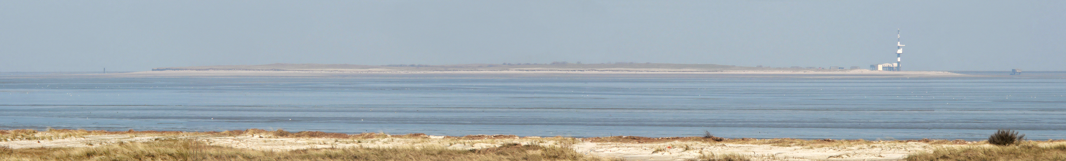
Flak Tower, Radar Tower, Lighthouse
After the Second World War, the British occupation forces considered letting the Jade silt up entirely to render Wilhelmshaven unusable as a naval base. They blew up one of the major embankments on Minsener Oog and then stopped. The German postwar administration patched the works back together. At the north end of Groyne A there is still a small concrete flak tower built during the war, which served as a lighthouse until 1998. A taller radar tower went up in 1976. Two groyne wardens once lived permanently on the island in pile dwellings, tending the engineering works in two-man shifts. In 1998 the Wilhelmshaven Water and Shipping Authority closed the permanent station for cost reasons. Now staff come and go as the maintenance schedule requires, and the only resident through the long summer is a bird warden from the Mellumrat conservation society.
Terns, Gulls, and Quiet
The island was placed under formal protection in 1959 as a major breeding site for North Sea seabirds. The 2004 species roll included herring gulls, lesser black-backed gulls, common gulls, common terns, Arctic terns, Sandwich terns, and little terns. Tern populations exceed two thousand pairs in good years. Shelducks and stock doves nest in the abandoned burrows left by rabbits, which were introduced long ago by lighthouse keepers as a living food reserve and never left. The island is considered one of the most important field sites for the Institute of Avian Research. Mudflat hikers from the mainland sometimes walk out at low tide in guided groups, but only a small section of the island is accessible to people. The rest is the quiet zone of the Lower Saxony Wadden Sea National Park - quiet in the very specific sense that humans are mostly not there.
From the Air
53.75N, 8.02E. Best visual approach is from the northwest, with the island appearing as a thin north-south strip running parallel to the Jade channel. Cruise at 3,000-5,000 ft and respect seasonal no-fly buffers over the nature reserve, especially between April and August. JadeWeserPort and Wilhelmshaven Power Station are visible to the south. Wilhelmshaven (EDWI) is the closest larger field; Wangerooge airfield (EDWG) sits about 10 km north. Visibility usually clearest mid-morning; coastal fog frequent at dawn.