Mission Dolores Park
On a sunny Saturday, up to 10,000 people spread across the grass of Dolores Park, and every one of them is lying on top of someone's grave. The park occupies land that was once a Jewish cemetery owned by Congregations Sherith Israel and Emanu-El, abandoned in 1894 when San Francisco banned burials within city limits. The graves were loaded onto Southern Pacific railcars and shipped to Colma. The dead left. The living moved in. That exchange, practical and unsentimental, is the founding gesture of one of San Francisco's most beloved public spaces.
From Cemetery to Refugee Camp to Park
In 1903, over a thousand property owners from San Francisco's southern neighborhoods formed the Mission Park Association and placed a ballot measure to buy the former cemetery and convert it to parkland. It passed with nearly 74 percent of the vote. Three years later, the park served an unplanned purpose: after the 1906 earthquake and fire, more than 1,600 families camped here, living in temporary shacks that dotted the hillside. Some kept those shacks as permanent houses; a few still survive scattered across western San Francisco. The J-Church streetcar line, which runs along the park's western border, began service in 1917, connecting the park to the city's transit network.
The Crossroads
Until World War II, the Mission District was largely European American. From the 1950s through the 1970s, Latino immigrants transformed the neighborhood. In 1962, a statue of Miguel Hidalgo, the father of Mexican independence, was erected in the park. Four years later, Mexican President Gustavo Diaz Ordaz presented a replica of the Mexican Liberty Bell, installed near the statue. The San Francisco Chronicle observed in 2009 that Dolores Park sits at the intersection of a number of San Francisco demographic groups: Latino families, young hipsters, Castro gays. The paper added: and it always has. The park hosts political rallies, Cinco de Mayo celebrations, Aztec ceremonial dances, San Francisco Mime Troupe performances, and the Sisters of Perpetual Indulgence's annual Hunky Jesus competition on Easter.
The Sunny Side of the Fog Line
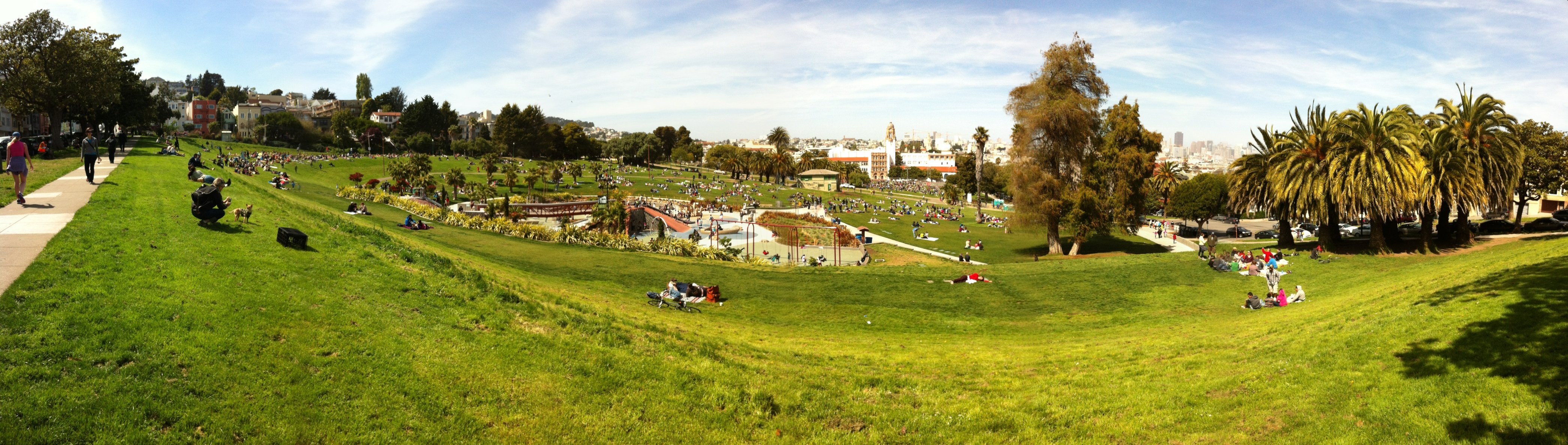
Dolores Park lies east of Twin Peaks in the Mission's warm microclimate, one of the sunniest spots in a city famous for fog. The park's southern half offers panoramic views of the Mission District, downtown, the bay, and the East Bay. This combination of sun, views, and accessibility has made the park a victim of its own popularity. A $20.5 million renovation completed in 2016, the park's first upgrade in six decades, added new restrooms, a pissoir, improved irrigation, the Helen Diller Playground with disability-accessible features, six tennis courts, and two off-leash dog areas. The renovation also launched a Leave No Trace campaign after decades of trash problems. On the sunniest weekends, Dolores Park is less a park than a festival that happens to have grass.
Layers Beneath the Lawn
Before the Jewish cemeteries, the Yelamu people of the Chutchui village lived on this land. After the Spanish founded Mission Dolores in 1776, European diseases decimated the indigenous population. Each layer of the park's history involved displacement: the Yelamu by the Spanish, the dead by the living, the European Americans by Latino immigrants, and now, increasingly, longtime Mission residents by tech-economy wealth. The park absorbs it all. It is bounded by 18th Street, 20th Street, Dolores Street, and Church Street, framed by two-to-four-story residential buildings in a jumble of architectural styles. Mission High School faces its northern edge. The J-Church streetcar rattles past. And 10,000 people lie on the grass on a Saturday, most of them unaware that beneath the soil, the outlines of old graves still trace the geometry of a city that has always been building over what came before.
From the Air
Located at 37.76°N, 122.43°W in San Francisco's Mission District, between 18th and 20th Streets. The park's rectangular green space is visible from altitude on the hillside east of Twin Peaks. Nearest airports: SFO (KSFO, 10 nm south), Oakland (KOAK, 11 nm east). The J-Church streetcar track along the park's western border is identifiable.