Mississippi River-Gulf Outlet Canal
They called it the Hurricane Highway. The Mississippi River-Gulf Outlet Canal, known locally as MRGO, was supposed to save New Orleans from economic irrelevance. Instead, it nearly drowned the city. Authorized by Congress in 1956 and completed in 1968, this 76-mile channel carved through the wetlands southeast of New Orleans was meant to give oceangoing vessels a shortcut from the Gulf of Mexico to the city's inner harbor, bypassing the winding Mississippi River. By the time Hurricane Katrina arrived in August 2005, the MRGO had become something far worse than a boondoggle: a funnel that amplified the storm surge by 20 percent and directed a wall of water into neighborhoods where hundreds of thousands of people lived.
A Shortcut Born of Rivalry
The idea first surfaced in the early 20th century, when the Port of New Orleans watched nervously as competitors gained ground. The completion of the Houston Ship Channel in 1914 gave the Port of Houston a decisive advantage: direct, fast access to the Gulf. New Orleans responded in 1923 by building the Industrial Canal to link the Mississippi River with Lake Pontchartrain, carving the Lower 9th Ward and New Orleans East into existence in the process. But it was not enough. By the 1940s, ships were growing larger, and the Industrial Canal's locks could not accommodate them. In 1943, the New Orleans Dock Board pitched a plan called the Alexander Seaway to the Army Corps of Engineers. Congress authorized the project in 1956, and construction began through the marshes of St. Bernard Parish, slicing through wetlands that had buffered New Orleans from Gulf storms for centuries.
A Channel That Devoured Itself
From the day it opened, the MRGO began destroying itself. The channel was designed at a modest width, but the surrounding marsh eroded relentlessly. Salt water from the Gulf infiltrated freshwater wetlands, killing vegetation whose roots held the soil together. By 2005, what had started as a navigable channel had ballooned to as much as 3,000 feet wide in some locations, nearly four times its original size. Annual dredging kept the bottom clear for ships, but nothing could stop the widening. The vanishing marshland was not just an environmental catastrophe. Those wetlands had served as a natural speed bump for hurricane storm surges, absorbing energy and reducing wave height. Each acre of marsh that disappeared left New Orleans a little more exposed to the next big storm.
The Billion-Dollar Ghost Ship
The grand economic vision never materialized. The Port of New Orleans had dreamed of relocating its entire operation to the inner harbor through a massive project called Centroport U.S.A. That plan quietly died in the mid-1980s for lack of funding. Maritime traffic on the MRGO dwindled steadily. By 2005, fewer than one oceangoing vessel per day used the channel on average, yet it cost $13 million annually to maintain. The nearly $1 billion price tag for a waterway that shaved just 37 miles off the existing route drew withering criticism. Even voters in St. Bernard Parish, the community the canal was supposed to help, had called for its closure before Katrina struck. Environmentalists warned that the channel was a ticking time bomb. Three months before the hurricane, Louisiana State University storm surge expert Hassan Mashriqui called the MRGO a "Trojan Horse" that could amplify storm surges by 20 to 40 percent.
Katrina's Funnel
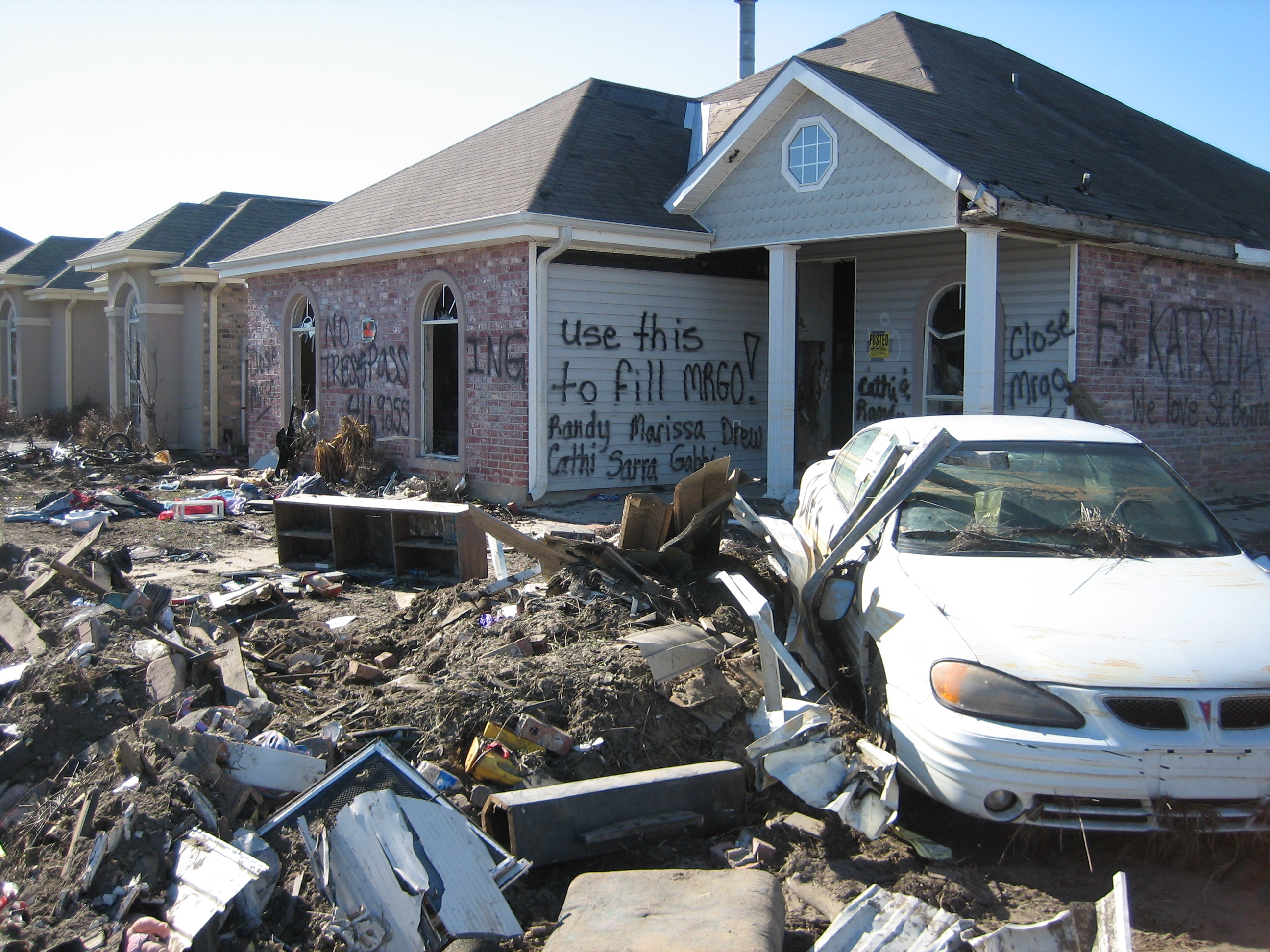
On August 29, 2005, Hurricane Katrina proved the warnings right. The MRGO and the Gulf Intracoastal Waterway converge in a funnel shape southeast of the city, and when Katrina's storm surge raced up the channel, that funnel compressed and accelerated the water. Engineering investigations later confirmed the surge was intensified by 20 percent, the wall of water raised roughly three feet higher, and its velocity dramatically increased in the convergence zone. Levees along the MRGO and the Intracoastal Waterway were breached in approximately 20 places, directly flooding most of St. Bernard Parish and New Orleans East. The surge is also considered a leading factor in the three catastrophic floodwall failures along the Industrial Canal. The aftermath was devastating: over 80 percent of New Orleans was underwater.
Closing the Highway
The storm surge left the MRGO choked with sediment and impassable for deep-draft vessels. St. Bernard Parish officials immediately demanded it stay closed. In May 2007, the Army Corps of Engineers announced the channel would be permanently shut, and an earthen dam would be built across it at Bayou La Loutre, following a natural ridge that had once sheltered inland marshes from the Gulf. The closure structure was completed in July 2009, and maritime traffic was officially barred on April 22 of that year. The Corps also drafted a $2.9 billion ecosystem restoration plan to revive the devastated wetlands, including freshwater diversions, tens of thousands of acres of marsh restoration, and 71 miles of shoreline protection. That plan was never funded. Today, the MRGO scar is still visible from the air, a wide gash through the Louisiana wetlands slowly being reclaimed by nature, a monument to the unintended consequences of reshaping a landscape.
From the Air
Located at 29.89N, 89.76W, the MRGO is visible from altitude as a wide, straight channel cutting SSE through the wetlands of St. Bernard Parish from New Orleans East toward the Gulf of Mexico. Look for the distinctive funnel shape where the MRGO converges with the Gulf Intracoastal Waterway near the I-510 bridge. The earthen closure dam at Bayou La Loutre is visible partway along the channel. Lake Borgne sits to the east. Nearby airports include Louis Armstrong New Orleans International (KMSY) approximately 25 miles west and Lakefront Airport (KNEW) approximately 10 miles northwest. The Industrial Canal is visible in New Orleans proper, connecting the Mississippi River to Lake Pontchartrain.