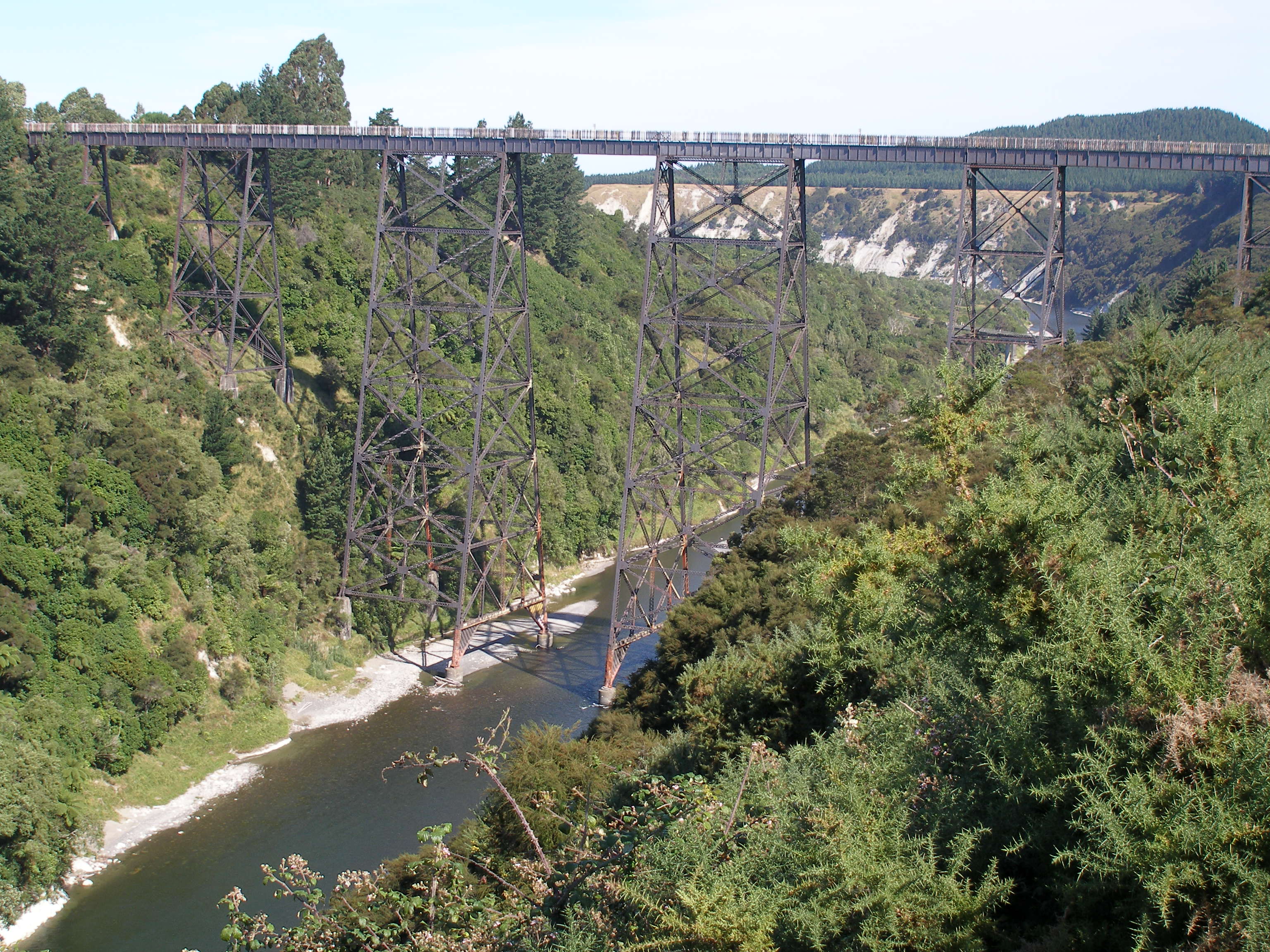
Mohaka Viaduct
Ninety-five meters straight down. That is the distance between the deck of the Mohaka Viaduct and the surface of the Mohaka River as it cuts through the gorges of northern Hawke's Bay. At 276.8 meters long, it remains the tallest railway viaduct in Australasia -- a steel lattice bridge built between 1930 and 1937 across some of the most difficult terrain the New Zealand Public Works Department ever confronted. The newspaper nickname for it was 'Bob's Meccano,' as if the thing were a toy. Stand beneath it and look up through the web of steel to the plate girders nearly a hundred meters overhead, and the joke falls flat.
A Seventy-Year Railway
The Palmerston North to Gisborne railway line was one of New Zealand's most ambitious and most troubled infrastructure projects. Construction began in 1872. The southern section, connecting Palmerston North with Napier, was completed by 1891. The northern section -- Napier to Wairoa, and then onward to Gisborne -- would take another fifty years. The terrain between Napier and Wairoa was the problem. The railway had to cross deep gorges carved by rivers draining the eastern ranges, through country so broken that it required five tunnels, five high steel viaducts, heavy earthworks, and numerous smaller bridges. Each section was opened as it was completed and handed over to the Railways Department. Progress was measured in kilometers per decade, not per year.
Sinking Foundations in a Riverbed
When the rail line reached the viaduct site in late 1930, the real engineering began. Pre-fabricated steelwork was shipped by rail from the small port of Waikokopu, about 40 kilometers east of Wairoa. Workers sank foundations 18 to 21 meters deep into the riverbed using pressurized caissons -- airtight chambers that allowed men to excavate underwater while compressed air held back the river. The piers rose from these foundations in stages, lifting the plate girder deck higher and higher above the gorge. Windbreaks were installed along the deck, extending well above the girders, to protect trains from the gale-force winds that could funnel through the valley. The construction was completed ahead of schedule and, remarkably, without a single recorded accident -- an achievement that seems almost unbelievable given the heights, the river, and the era.
Pressed Into Service Before Its Time
In April 1938, catastrophic floods swept through the Mohaka River valley and washed away sections of the low-level road bridge downstream. The viaduct, not yet carrying regular train service, was pressed into emergency duty as a road crossing. Cars and trucks crept across a structure designed for locomotives, 95 meters above a river swollen with floodwater. It was a temporary measure born of necessity, but it demonstrated something about the viaduct's construction: the structure was overbuilt, solid enough to carry whatever the situation demanded. When regular train service finally began, the viaduct became the centerpiece of one of New Zealand's most scenic -- and most precarious -- railway routes.
Mothballed, Revived, Mothballed Again
The Napier-Gisborne line never found financial stability. Severe storm damage between Wairoa and Gisborne repeatedly undermined the track, and the economics of maintaining a railway through such demanding country grew harder to justify with each repair bill. In early 2012, KiwiRail mothballed the section north of Wairoa. By October of that year, the entire line from Napier to Gisborne was shut down. The viaduct stood silent above the river, carrying nothing. Then in 2019, trains returned. The line reopened, and the Mohaka Viaduct resumed its improbable function: holding a railway 95 meters in the air over a river that floods, through hills that slip, along a route that accountants keep trying to close. Whether the line survives long-term remains an open question, but the viaduct itself is not going anywhere. Heritage New Zealand lists it as a Category 1 Historic Place -- a monument to the era when New Zealand believed no gorge was too deep and no hill too steep to lay rail across.
From the Air
The Mohaka Viaduct (39.04S, 177.07E) spans the Mohaka River gorge near the small settlement of Raupunga in northern Hawke's Bay. From the air, the viaduct is visible as a long steel structure crossing a deep river gorge, with State Highway 2 and a lower road bridge running parallel nearby. The terrain is hilly and bush-covered, with the river winding through steep-sided gorges. Napier Airport (NZNA, also known as Hawke's Bay Airport) lies approximately 80 km to the south. The surrounding area has limited flat ground. Recommended viewing altitude: 1,500-3,000 ft AGL for the full gorge-and-viaduct perspective.