Molenbeek-Saint-Jean
It is named after a brook. Molenbeek means millbrook in Old Dutch - the stream that once turned the wheels of the medieval mills west of Brussels. The brook is mostly invisible now, channeled underground beneath one of the densest, most heterogeneous, most argued-about communes in the Brussels-Capital Region. Six square kilometers, ninety-eight thousand people, twice the population density of the city it borders. A 1930s Art Deco parish church on a square named for John the Baptist. A converted bronze foundry that is now the Brussels Museum of Industry and Labour. The Vaartkapoen, a bronze policeman being tackled by a hooligan emerging from a sewer grate, sculpted by Tom Frantzen as a love letter to the local sense of humor. And, yes, a much darker chapter in the 2010s that briefly turned the name into international shorthand. The neighborhood has been working on the rest of the sentence ever since.
Mills, Then Factories
The first mention of Molembecca dates from around 985, when the name still belonged only to the brook. By the Middle Ages the rural village had its own identity, sitting on the western edge of Brussels along the road to Ghent. For most of its first thousand years it stayed small - 690 people in 1707, fewer than 2,000 at the start of the nineteenth century. Then came the Industrial Revolution, the Brussels-Charleroi Canal cut along its eastern edge in the 1830s, and the population exploded. Twelve thousand by 1846. Thirty-seven thousand by 1876. Seventy-two thousand by 1910, when Molenbeek was one of the most heavily industrialized neighborhoods in northern Europe. Foundries, breweries, the Gosset factory with its Art Deco modernism, the gigantic Tour and Taxis goods station nearby. The Compagnie des Bronzes de Bruxelles - which, much later, would cast a replacement Manneken Pis - operated its main smelter here from 1854 to 1979. When the European port area along the canal was annexed by the City of Brussels in the late 1800s, Molenbeek lost a chunk of its economic base. The slow deindustrialization that followed left a difficult legacy.
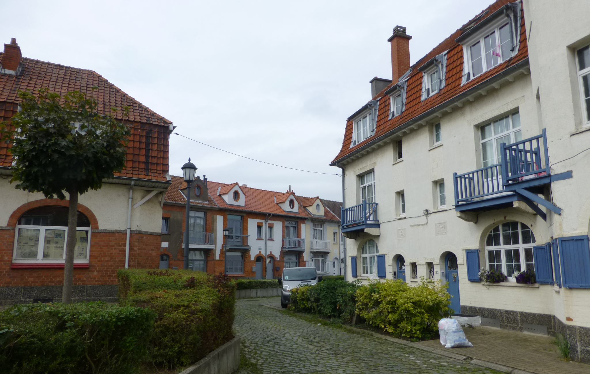
Two Halves of a Commune
Modern Molenbeek breaks roughly into two geographies. The lower area, against the canal, is the historical industrial core - dense, working-class, predominantly migrant, with a strong Moroccan presence, particularly families of Riffian Berber origin, now in their second and third generations. The Parvis Saint-Jean-Baptiste square sits at its heart, with the Art Deco Church of Saint John the Baptist (built 1930-1932) rising over it. The 1854 Fonderie foundry is now the Brussels Museum of Industry and Labour, focused on the social history of industrialization in the commune. The 1889 eclectic-style Municipal Hall by Jean-Baptiste Janssens stands on the Place Communale a few blocks away. The upper area, on the western side near the Greater Ring, is mostly middle-class and residential - Karreveld Park around the old Karreveld Castle, the garden city Cite Diongre built in the 1920s, the wooded Scheutbos semi-natural reserve at the western edge. Albert Park and Marie-Jose Park, laid out in 1920 by urban planner Louis Van der Swaelmen, are named for King Albert I and his daughter, the last queen of Italy. The neo-Gothic Churches of Saint Remigius (1907) and Saint Barbara (1894) anchor their own neighborhoods.
Vaartkapoen and the Other Citizens
On the Place Sainctelette, the sculptor Tom Frantzen installed a bronze called De Vaartkapoen in 1985 - a Brussels policeman being yanked off his feet by the arm of a hooligan reaching up through a manhole. The title is the Brusselian dialect nickname for a Molenbeek native: literally a roughneck from the canal. It captures something the commune cherishes about itself: a refusal to take authority too seriously, an inheritance from the working-class neighborhoods that once defined the place. The Vaartkapoen sculpture has become one of the most-photographed pieces of street art in Brussels. The word zinneke - mutt, mongrel, used affectionately for a person who isn't quite from anywhere - originated with the stray dogs of the nearby canal. Molenbeek has been making zinnekes for two centuries.
2015 and After
In the autumn of 2015, terrorists murdered 130 people in coordinated attacks across Paris. The investigation that followed traced the planning back to Molenbeek - at least four of the attackers, including the brothers Brahim and Salah Abdeslam and the alleged organizer Abdelhamid Abaaoud, had grown up here. On 18 March 2016 Belgian police arrested Salah Abdeslam in the commune. The Brussels airport and metro bombings followed days later. The reckoning was painful and partly justified. Belgian intelligence and the municipal authorities had let problems fester for years. The then-mayor Philippe Moureaux, who ran the commune from 1992 to 2012, had been criticized in 2010 for dismissing a Kalashnikov shootout outside a Molenbeek currency exchange as a fait divers, normal in a large city. After the attacks, a door-to-door security operation investigated about 22,668 residents - roughly a quarter of the commune. Of 1,600 organizations checked, 102 were found to have criminal links and 52 to have terrorist links. Seventy-two individuals were put under future surveillance. The honest figures matter, because the dishonest ones - turning a commune of nearly a hundred thousand people into a single headline - never fit the reality of the place.
What Comes Next
Walk through the lower commune today and you find a serious revitalization underway, the Plan Canal program that is rebuilding the canal corridor with mixed housing, cultural venues, and converted industrial buildings. Old breweries are now hotels - the Hotel Belvue, the Brussels Event Brewery. The Tour and Taxis goods station has been transformed into apartments, offices, and Brussels' Circus School. The MoMuse, the Municipal Museum of Molenbeek, occupies the building of the old Academy of Drawing and Visual Arts. Unemployment among young people is still high - nearly forty percent in some streets - and the migrant communities still face the slow grind of European integration. About a quarter to forty percent of residents are described as Muslim, depending on the catchment area; the majority of permanent migrants from outside the EU have acquired Belgian nationality. The commune holds elections, argues about its mayors, fights with the regional authorities, builds parks, restores monuments, and continues to be one of the most stubbornly alive places in Brussels. The people who live here would prefer that you visit it for the foundry museum, the canal-side cafes, the Vaartkapoen, the Art Deco church, the markets full of Moroccan tea and Berber bread - all the things that have made Molenbeek Molenbeek for the last hundred and seventy years. The brook is still there, underground. So is everyone else.
From the Air
Located at 50.85N, 4.32E in the western part of the Brussels-Capital Region, bordered to the east by the Brussels-Charleroi Canal. Total area 6.02 square km. From altitude, look for the line of the canal cutting north-south, the Tour and Taxis complex just north of the commune, and the dense urban grid extending west to the Greater Ring. Nearest airport is Brussels (EBBR) about 10 km northeast. Charleroi (EBCI) lies 50 km south. Oceanic climate - expect frequent rain (about 130 days per year) and summer thunderstorms.