Molokini
From a boat, Molokini looks like a jaw rising from the sea. Half a mouth, teeth of basalt, the rest swallowed long ago by the Pacific. Hawaiian legend offers a different anatomy: the fire goddess Pele, furious with jealousy, cut a beautiful woman in two and turned her to stone. The crescent that remains is Molokini. The woman's severed head became Pu'u Olai, the cinder cone on the shore at Makena Beach, still gazing back at her own body across two and a half miles of channel. Whether you believe the geology or the myth, the shape is extraordinary -- a nearly perfect half-circle of volcanic rock, 23 acres of uninhabited islet rising 161 feet above the waterline, sheltering one of Hawaii's richest underwater ecosystems inside its concave embrace.
230,000 Years in the Making
Molokini erupted approximately 230,000 years ago, one of seven Pleistocene-era volcanoes that together formed Maui Nui, the prehistoric superisland that once connected Maui, Molokai, Lanai, and Kahoolawe before rising seas separated them. What remains above water is a partial tuff cone, its open side facing southwest, its interior forming a shallow cove where the ocean floor slopes gently to about 55 feet before dropping off the outer wall in a sheer 300-foot plunge. That outer wall is where the geology becomes dramatic: a vertical cliff face descending into deep blue water, encrusted with corals and patrolled by pelagic species that rarely venture into the sheltered interior. The islet sits in the Alalakeiki Channel, close enough to Maui to reach by boat in under an hour, far enough offshore that the water remains startlingly clear.
Target Practice and Black Coral
Molokini's crescent profile, which from certain angles resembles a battleship's silhouette, attracted the wrong kind of attention during World War II. The U.S. Navy used the islet for target practice, pounding its slopes with ordnance. The damage lingered for decades. In 1975 and again in 1984, the Navy returned to detonate unexploded munitions found within the crater, destroying large areas of coral reef in the process. Public outrage followed each detonation. Volunteer divers eventually conducted a thorough search of the crater floor, manually removing remaining ordnance and carrying it to deep water. A 2006 survey found no further unexploded munitions, but the southwest rim still bears visible scarring from the shelling. Between the 1950s and 1970s, commercial divers harvested black coral from Molokini's walls, further stressing the reef ecosystem. In 1977, the state of Hawaii declared Molokini and 77 surrounding acres of underwater terrain a Marine Life Conservation District, ending extraction and beginning recovery.
A Glass-Bottomed Nursery
Inside the crescent, protected from the open channel's powerful currents, the reef has rebuilt itself into one of Maui's premier dive and snorkel destinations. Water clarity can reach 150 feet on calm mornings, revealing a seafloor that mixes sand patches, basalt boulders, and living coral. Approximately 250 species of fish inhabit the crater, including black triggerfish, yellow tang, Moorish idol, parrotfish, raccoon butterflyfish, and bluefin trevally. Humpback whales pass through the cove during winter months. There are no beaches to land on and no structures on the islet, which also serves as a Hawaii State Seabird Sanctuary. The success has created its own pressure. Over 300,000 visitors arrive by boat each year, and the constant parade of hulls threatened the reef with anchor damage until the state installed mooring buoys and established day-use rules. A proposed 2019 bill aimed to reduce the number of allowed moorings from over 20 to 12, acknowledging that even well-managed tourism can overwhelm a 23-acre ecosystem.
The View from Above
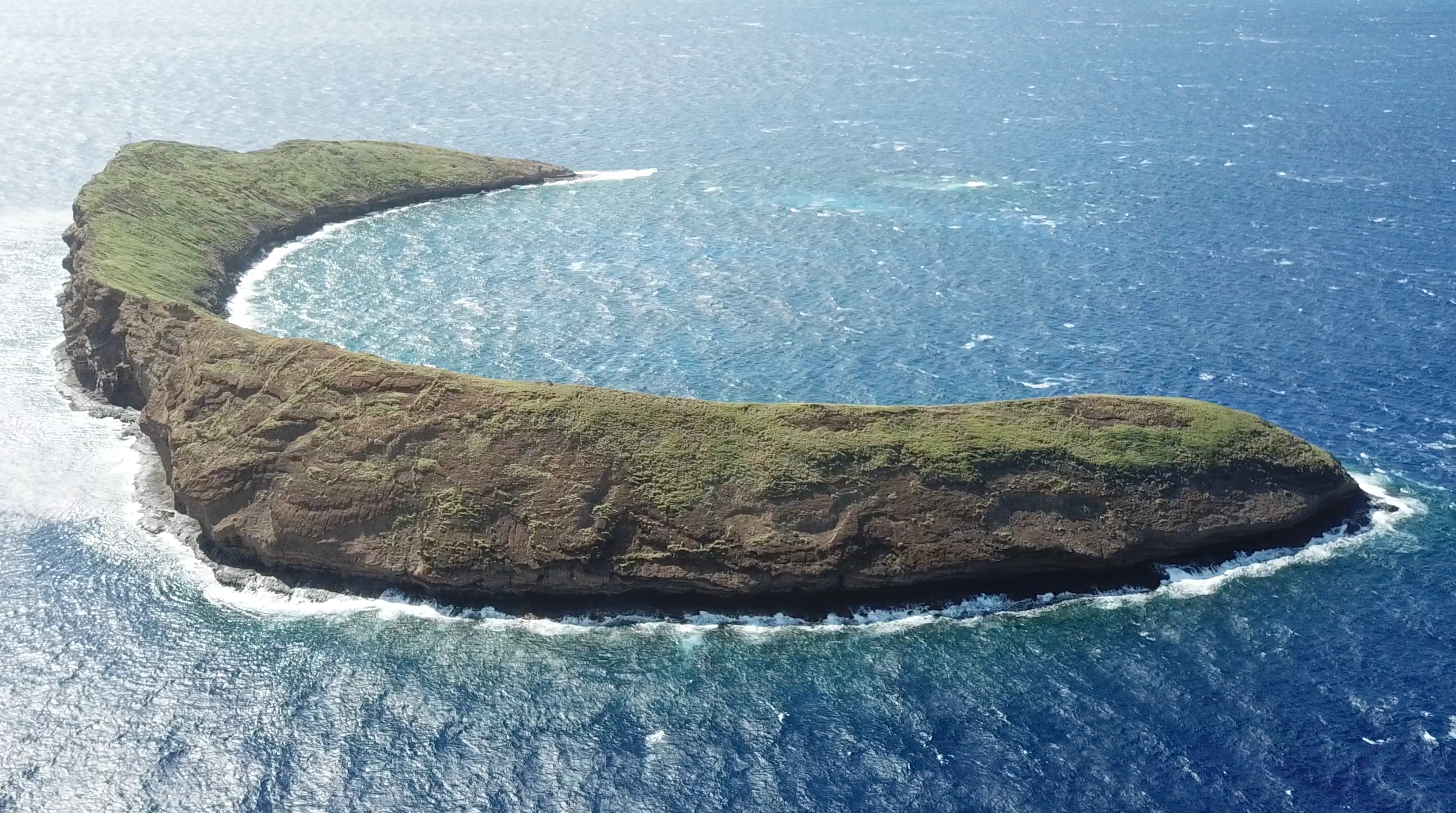
Seen from the air, Molokini resolves into its truest shape: a thin arc of dark rock enclosing a pool of turquoise water, set against the deep indigo of the Alalakeiki Channel. The contrast is almost artificial in its perfection. Inside the crescent, the water shades from pale aquamarine over the sandy shallows to emerald green where the reef thickens, then drops suddenly to cobalt blue at the outer wall. Boats cluster at the mooring buoys like white beads on a string. Beyond the islet, the hulk of Kahoolawe fills the southern horizon, and behind it the open Pacific stretches to the edge of the world. Early morning is the best time to see all of this clearly, before the trade winds chop the surface and the afternoon clouds build over the West Maui Mountains. By then the tour boats have turned for harbor, and Molokini returns to what it has been for 230,000 years: a half-circle of stone, uninhabited, holding the ocean at bay.
From the Air
Located at 20.63N, 156.50W in the Alalakeiki Channel between Maui and Kahoolawe. The crescent shape is unmistakable from the air, a dark arc of rock enclosing turquoise water. Tour boats cluster inside the crater on most mornings. The uninhabited island of Kahoolawe lies to the south. Nearest airport: Kahului Airport (PHOG, approximately 15 miles north-northeast). Best viewed at 2,000-5,000 feet AGL for the full crescent shape and water color contrast. Morning offers the clearest conditions before trade winds build.