Monastery of Serra do Pilar
Most monasteries are built for withdrawal from the world. The Monastery of Serra do Pilar was built to command it. Perched on a rocky outcrop in Vila Nova de Gaia, directly across the Douro from Porto's historic center, it occupies one of the most strategic and visually dramatic positions in all of Portugal. From its terrace, the entire sweep of Porto unfolds: the red roofs cascading down to the Ribeira waterfront, the Dom Luis I Bridge arching across the gorge, the port wine cellars lining the riverbank below. When Arthur Wellesley needed a headquarters to plan his surprise crossing of the Douro in 1809, he chose this spot. The monastery's architects had understood what military commanders later confirmed -- whoever holds this hilltop sees everything.
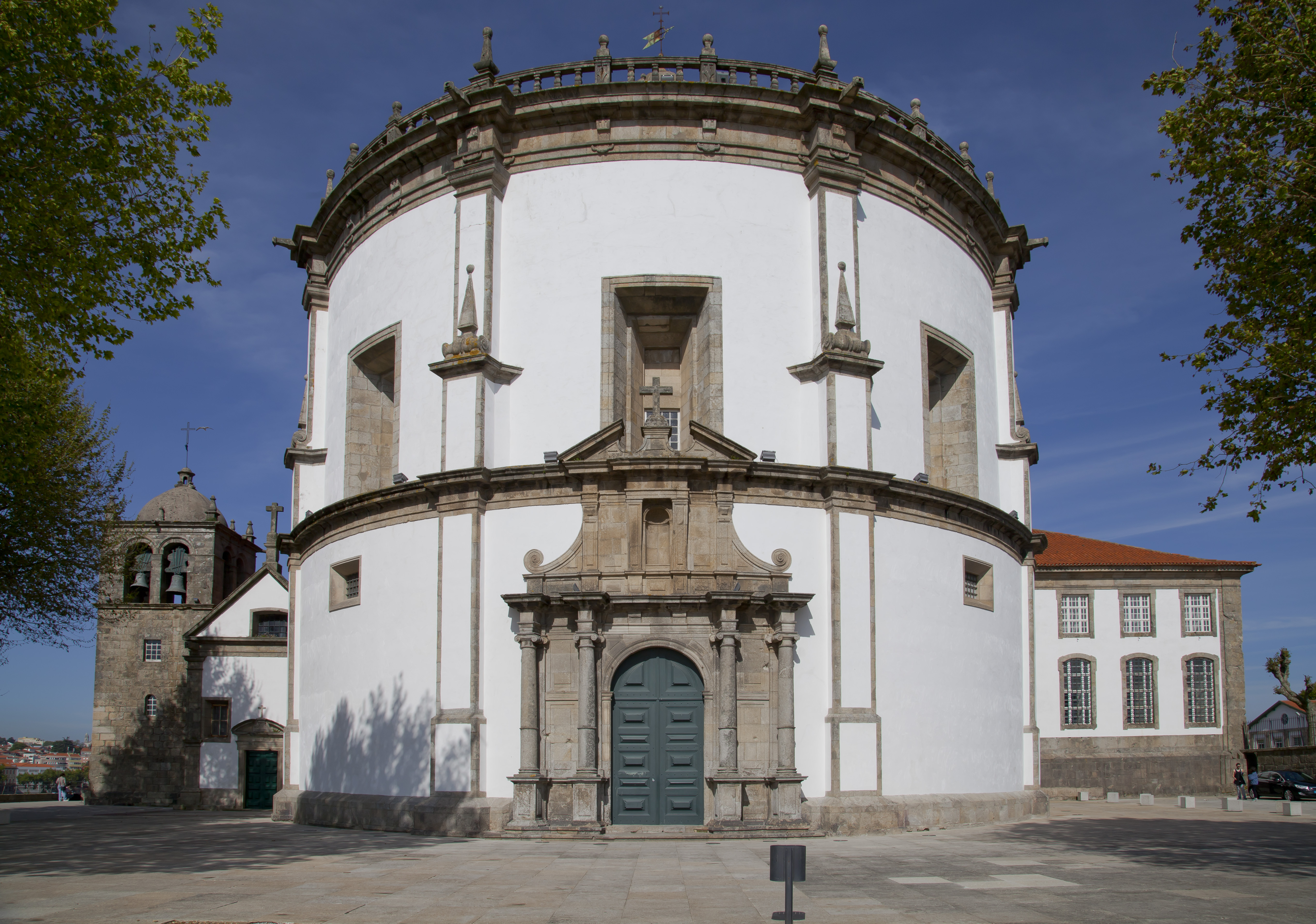
Circles Within Circles
What makes the Monastery of Serra do Pilar architecturally unique is its geometry. Both the church and the cloister are circular, with identical diameters, connected by a rectangular choir and chapel. The circular church sits to the west, the cloister to the east, and together they form one of the most unusual monastic complexes in Western Europe. The design reflects Renaissance and Mannerist influences, a departure from the rectangular plans that governed nearly every other monastery of the era. The church dome dominates the skyline of the Douro's south bank, taller than the bell tower beside it, visible from miles away. Inside, the circular space creates acoustic effects that make even whispered prayers resonate.
Five Centuries of Construction
The Augustinian monks who built the monastery needed two attempts to get it right. Construction of the first monastery began in 1538, ordered by King Joao III to replace a deteriorating monastic house in Grijo. By 1564 the original building was complete, its cloisters finished in 1583. But the facilities proved too small for the growing number of monks, and by 1597 work had begun on the new circular church. The project moved in phases across the following decades. The new church was finally inaugurated on July 17, 1672, and the remaining wings were completed by the end of the 17th century. What visitors see today is essentially the second monastery, a building that took over a century to finish and replaced an earlier structure that lasted barely three decades before obsolescence.
From Monastery to Fortress
The monastery's hilltop position made it irresistible to military planners. During the 19th century, the complex was fortified to exploit its commanding view of the Douro crossing and the approaches to Porto. In May 1809, General Arthur Wellesley established his headquarters here during the Second Battle of Porto, scanning the north bank through a telescope and identifying the unoccupied seminary that would become the bridgehead for his surprise river crossing. Artillery positioned in the monastery's garden fired shrapnel across the river with devastating effect on French counterattacks. The monastery's role in the Peninsular War cemented its dual identity as a place of both contemplation and conflict, a sacred space repurposed by the demands of war.
The View That Defines Porto
In 1910, the Monastery of Serra do Pilar was declared a National Monument of Portugal. In 1996, UNESCO inscribed it as part of the Historic Centre of Porto World Heritage Site, alongside the Dom Luis I Bridge and the medieval Ribeira quarter across the river. Today visitors reach the monastery via the Jardim do Morro station on the Porto Metro's D Line or by the Gaia Cable Car from the riverside. But the monastery's greatest gift remains what it has always offered: the panorama from its terrace. Standing at the edge, with the Douro curving below and Porto's layered cityscape rising on the opposite bank, you understand why monks chose this outcrop nearly five centuries ago and why no visitor to Porto should leave without climbing to it.
From the Air
Located at 41.138N, 8.608W on a prominent outcrop on the south bank of the Douro in Vila Nova de Gaia, directly opposite Porto's historic center. The circular church dome is visible from the air as the dominant structure on the south bank skyline. The Dom Luis I Bridge and Maria Pia Bridge are immediately adjacent landmarks. Francisco Sa Carneiro Airport (LPPR/OPO) is 12km northwest. Best viewed at 1,500-2,500 feet where the monastery's hilltop position and circular geometry are apparent. Oceanic climate with possible morning river fog.