Monocacy Aqueduct
Thomas Walter loved the South. He also loved the Monocacy Aqueduct more. In September 1862, as Confederate General D.H. Hill marched toward Antietam with orders to destroy the largest aqueduct on the Chesapeake and Ohio Canal, Walter - keeper of Lock 27 and a Confederate sympathizer himself - talked the general out of it. Drain the canal instead, Walter argued, and you achieve the same military objective without reducing 438 feet of quartzite masonry to rubble. Hill agreed. The aqueduct survived that day, survived a second demolition attempt days later when Confederate soldiers found the stone too hard to drill, survived Hurricane Agnes in 1972, and still stands where it has stood since 1833 - carrying the ghost of a canal across the Monocacy River in Frederick County, Maryland, just upstream from where the Monocacy empties into the Potomac.
Quartzite from the Mountain
Building the Monocacy Aqueduct was a lesson in persistence. The first contract went to Hovey and Legg in August 1828, but the project defeated them. The contract passed to Asher Osbourn, who fared no better. By the end of 1830, Byrne and Lebaron held the work, and they would see it through to completion in 1833. Chief engineer Benjamin Wright designed a stone masonry structure of seven arches, each spanning 54 feet, supported by six piers ten feet thick and capped with pilasters at each end. The waterway measured 19 feet at the bottom and 20 at the top, flanked by a towpath parapet wall eight feet wide. Much of the building material came from Sugarloaf Mountain, a monadnock rising from the Piedmont a few miles to the southeast. Quartzite blocks were cut from its base and hauled to the river crossing - the same dense, crystalline stone that would later frustrate Confederate demolition teams trying to drill holes for explosives. The total cost was $127,900, a substantial investment in an era when the entire canal was a gamble on American infrastructure.
The Lockkeeper's Bargain
The Civil War turned the C&O Canal into a strategic artery. The Union used it to move troops and war materials along the border between Maryland and Virginia, making every aqueduct, lock, and towpath a potential target. Confederate sympathizers were scattered among the canal employees, men who knew every weakness in the system they operated. Thomas Walter was one of them. But when General D.H. Hill arrived in September 1862 with orders to destroy the Monocacy Aqueduct during the Antietam campaign, Walter saw something more valuable than military strategy in those seven arches. He convinced Hill that simply draining the canal would halt boat traffic just as effectively - no need to destroy a structure that had taken five years and three contractors to build. Hill, perhaps persuaded by the logic or perhaps by something in Walter's urgency, agreed. Days later, a second Confederate party arrived with more straightforward intentions: blow the aqueduct to pieces. They drilled into the quartzite, placed their charges, and discovered what Sugarloaf Mountain's stone had always known about itself. The rock was too hard. They could not bore enough holes to place enough explosives to breach the structure.
Flood and Restoration
The aqueduct endured the Civil War intact, but time and water proved more patient adversaries. Hurricane Agnes swept through the Potomac watershed in June 1972, inflicting serious damage on canal structures that had been deteriorating since the canal's commercial closure in 1924. The National Park Service, which administers the aqueduct as part of the C&O Canal National Historic Park, worked with the Federal Highway Administration to stabilize the structure using a steel banding system and reinforcing rods - engineering interventions that held the stone together but left visible scars on Wright's original design. For decades, park supporters worried about the aqueduct's long-term stability. A major engineering evaluation finally led to a comprehensive restoration between 2004 and 2005 that returned the structure to its original appearance. The aqueduct was formally rededicated in May 2005, 172 years after Byrne and Lebaron set the last stone in place.
What Remains at the River
Walk the towpath today and the aqueduct appears much as canal boatmen would have seen it in the 1830s - seven arches of pale quartzite spanning the Monocacy River, the waterway dry now but the walls intact, the parapet still wide enough for a mule team. Near the parking lot stand the remains of a granary, a modest one-story structure with three storage bays and two boat passageways, similar to the one at nearby White's Ferry. It is a reminder that the canal was not merely an engineering achievement but a working commercial corridor, moving grain and coal and timber through a landscape that had no railroads yet. The Monocacy Aqueduct is the largest of the C&O Canal's aqueducts, and the one that came closest to destruction - saved not by military strategy or structural engineering but by a lockkeeper who understood that some things, once demolished, cannot be rebuilt.
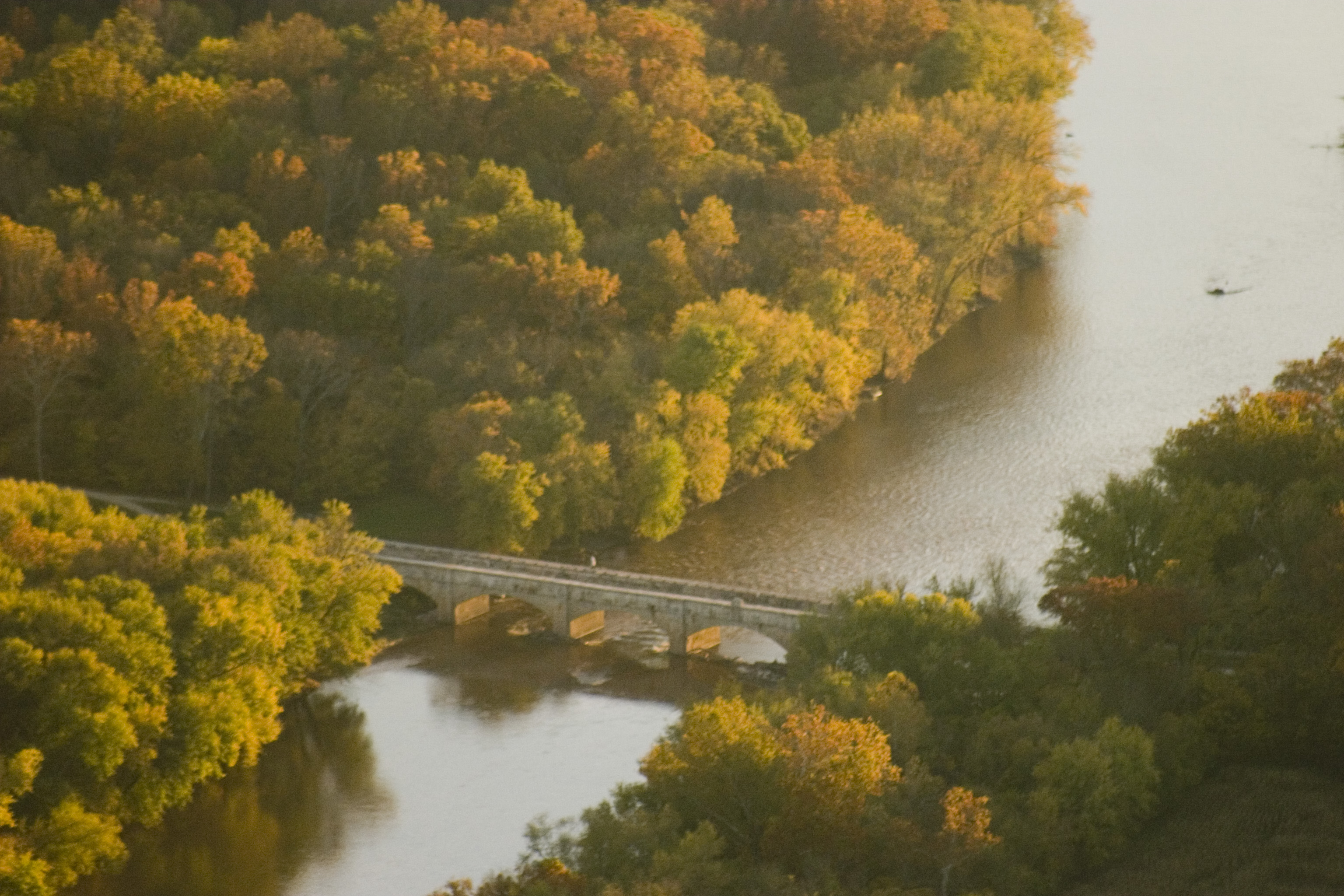
From the Air
Located at 39.22°N, 77.45°W in Frederick County, Maryland, where the Monocacy River meets the Potomac. The aqueduct is visible as a linear stone structure crossing the Monocacy just upstream of its confluence. Sugarloaf Mountain, source of the quartzite blocks, rises distinctly from the Piedmont about 5nm to the southeast - an isolated monadnock unmistakable from the air. The C&O Canal towpath traces the north bank of the Potomac. Frederick Municipal Airport (KFDK) lies approximately 10nm to the north. The area is beneath the Washington SFRA, requiring coordination. Best viewed at 1,500-2,500 feet AGL, following the Potomac westward from the Point of Rocks gap.