Monte Pissis
For nearly half a century, nobody came back. Two Polish climbers, Stefan Osiecki and Jan Alfred Szczepanski, reached the summit of Monte Pissis in 1937 as part of the Second Polish Andean Expedition. Then the mountain waited. No one stood on top again until 1985. This is not a peak that punishes with technical difficulty — the ascent requires no ropes, no ice axes, no specialized climbing skill. What keeps people away is sheer remoteness: a massive extinct volcano straddling the border of Argentina's La Rioja and Catamarca provinces, buried deep in the driest desert on Earth, days of hiking from the nearest road.
A Giant in Dispute
Monte Pissis is the second-tallest volcano on Earth and the third-highest mountain in the Western Hemisphere, trailing only Aconcagua and Ojos del Salado. But for a decade, even that ranking was in question. A 1994 Argentine expedition used GPS technology to measure the summit and declared Pissis taller than Ojos del Salado, which would have made it the world's highest volcano. The claim stood until 2005, when an Austrian team returned with differential GPS equipment and found the earlier measurements inaccurate. A 2007 multinational expedition confirmed what the Austrians had found: Ojos del Salado stands higher. The episode is a reminder of how recently the basic dimensions of the Andes were still being settled — and how a few meters of elevation, in these rarefied altitudes, can reshape a mountain's place in the record books.
Fire Frozen in Stone
The volcano formed between 6.6 and 6.2 million years ago, built from andesitic and dacitic lava that erupted as the Nazca Plate dove beneath the South American continent. Monte Pissis is part of a volcanic complex it shares with Cerro Bonete Chico and Incapillo, a cluster of peaks among the highest volcanic structures on the planet. Volcanism in the region ceased roughly two million years ago, but the landscape still bears its fingerprints. Incapillo, which formed after Pissis had gone quiet, may still harbor hydrothermal activity beneath its surface. The mountain takes its name from Pedro Jose Amadeo Pissis, a French geologist who surveyed the Chilean side of the Andes for the Chilean government in the nineteenth century — a fitting namesake for a peak whose geology has drawn scientists back repeatedly.
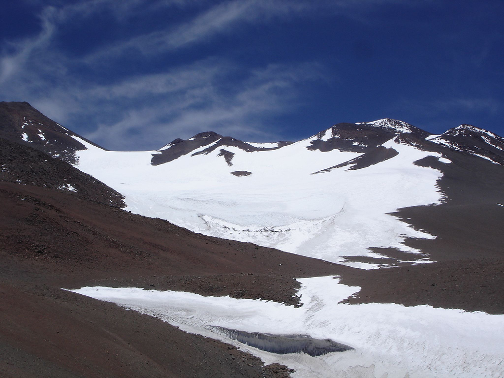
Ice in the Desert
A glacier on a mountain in the Atacama Desert sounds like a contradiction, but Monte Pissis carries one. The peak is one of the most heavily glaciated summits in the desert, with crevassed ice fields that begin at extreme altitude. The glacier is small relative to the mountain's enormous bulk, but its presence at all is remarkable in a region where annual rainfall can be measured in single-digit millimeters. Despite this ice, Pissis holds a paradoxical distinction: it is the highest summit on Earth without a permanent glacier. The existing ice is classified differently — seasonal and wind-deposited rather than a true accumulation glacier — which gives the peak a strange dual identity as both glaciated and glacier-free, depending on how strictly you define the term.
The Approach Is the Climb
Mining roads built in recent decades have opened the Atacama to visitors who once would have needed expedition-scale logistics just to reach the mountain's base. Most climbing parties now stage from Fiambala, a small town in Catamarca province, before driving deep into the desert. The route from Chile is possible but longer. From a base at the foot of the mountain, several days of hiking across barren terrain lead to a high camp at the edge of the glacier. The summit push from there is straightforward. What is not straightforward is the cold. Nighttime temperatures plummet far below freezing, and winds scour the ridges with a ferocity that makes warm clothing and sturdy boots essential survival gear rather than comfort items. The climbing window runs from December through March, the Southern Hemisphere's summer, when conditions are merely harsh rather than impossible.
From the Air
Monte Pissis is located at 27.76°S, 68.80°W, on the border of La Rioja and Catamarca provinces in northwestern Argentina. At roughly 6,800 meters, it is a massive terrain feature visible from well over 100 nautical miles in the clear Atacama air. The summit sits in extremely remote terrain with no nearby airports; the closest significant airfield is Catamarca Airport (SANC) approximately 300 km to the east. Pilots should expect high-altitude turbulence, extreme terrain, and rapidly changing mountain weather. The surrounding landscape is barren volcanic desert with salt flats and neighboring peaks exceeding 6,000 meters.