Monument Valley
The Navajo call it Tse Bii Ndzisgaii - valley of the rocks. Long before a single camera arrived, the Navajo Nation considered this landscape sacred. Then, in 1938, director John Ford drove into the valley with John Wayne and a film crew, and the buttes of Monument Valley became the American West itself. Film critic Keith Phipps wrote that the formations "have defined what decades of moviegoers think of when they imagine the American West." That image - red sandstone towers against an impossibly blue sky, a lone rider silhouetted on the valley floor - was manufactured in Hollywood but rooted in geology millions of years old. The valley sits on the Colorado Plateau, straddling the Utah-Arizona state line, and its largest buttes rise over 1,000 feet above the desert floor.
Written in Stone
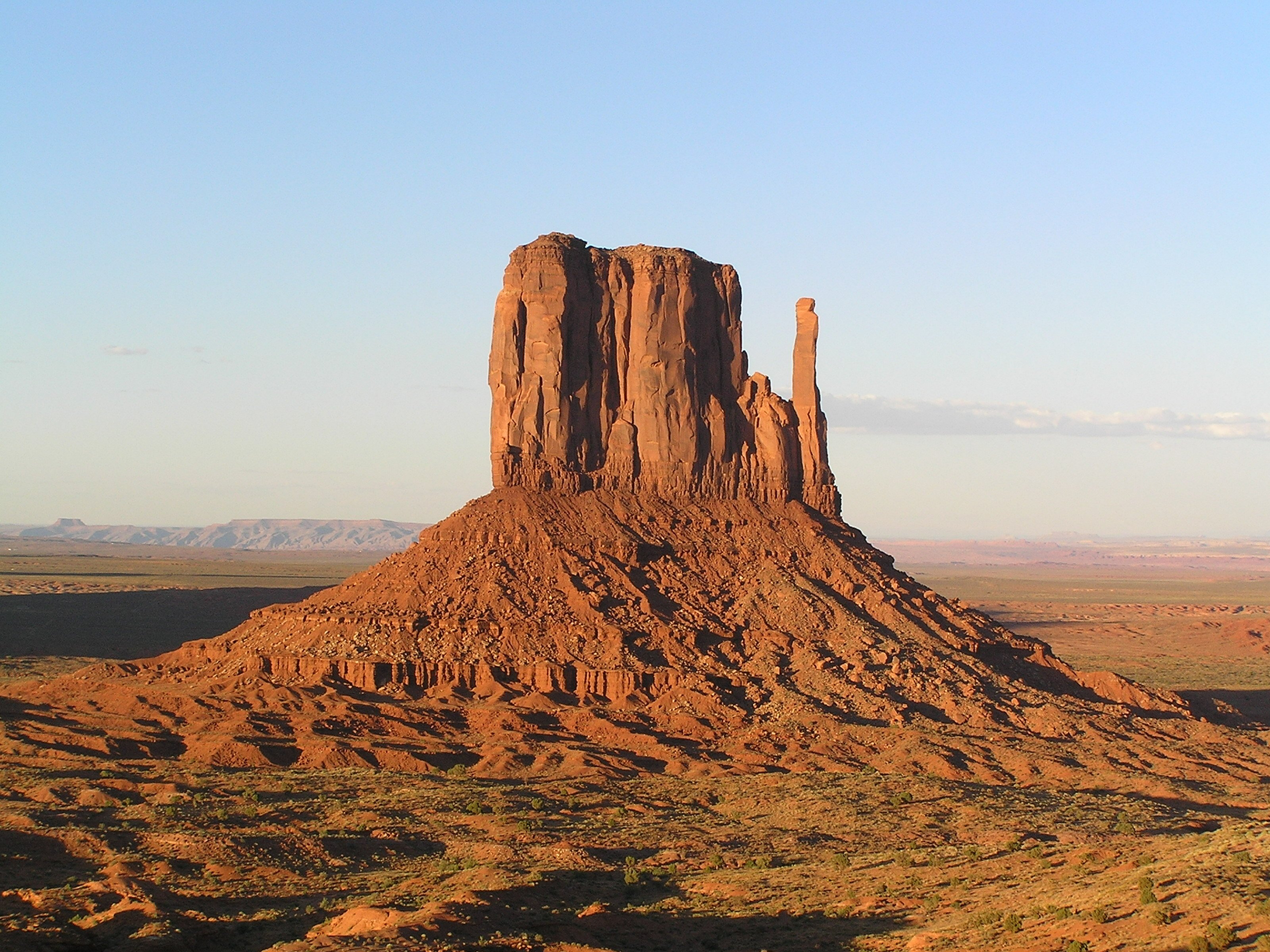
The valley floor is composed largely of siltstone from the Cutler Group, deposited by ancient rivers that carved the landscape over millions of years. Iron oxide in the weathered siltstone produces the vivid red coloration that defines the valley; darker blue-gray rocks owe their color to manganese oxide. The buttes themselves are clearly stratified into three principal layers: Organ Rock Shale at the base, de Chelly Sandstone in the middle, and the Moenkopi Formation capped by Shinarump Conglomerate at the top. These layers record geological epochs - ancient deserts, shallow seas, river deltas - stacked like pages of a stone book. The formations have names that read like a frontier inventory: West and East Mitten Buttes, Merrick Butte, Elephant Butte, Camel Butte, King-on-his-Throne, Rooster Rock, and Setting Hen. The Totem Pole, a slender spire of eroded sandstone, stands as one of the most photographed formations in the American Southwest.
Ford's Cathedral
John Ford filmed Stagecoach here in 1939, transforming a dying genre into the epitome of American cinema. He returned again and again: My Darling Clementine in 1946, Fort Apache in 1948, She Wore a Yellow Ribbon in 1949, The Searchers in 1956. Ford treated the valley as a character in its own right - the buttes framing his stories of frontier conflict and moral reckoning. Other directors followed. Sergio Leone filmed Once Upon a Time in the West here in 1967, making it the first Spaghetti Western shot outside Europe. The valley has appeared in countless films since, from 2001: A Space Odyssey to Forrest Gump. It has become so iconic that a stretch of U.S. Route 163 approaching from the north is informally known as Forrest Gump Point - the spot where Tom Hanks's character finally stops running.
Navajo Sacred Ground
Monument Valley lies entirely within the Navajo Nation, the largest Native American reservation in the United States. The valley is managed as Monument Valley Navajo Tribal Park, a Navajo Nation equivalent to a national park. Visitors pay an access fee and can drive a 17-mile dirt road loop through the park, but areas like Mystery Valley and Hunts Mesa are accessible only by Navajo-guided tour. The Navajo relationship with this land predates European contact by centuries. The valley is not a spectacle to be consumed but a living sacred landscape. Tourism provides essential income for the Navajo Nation, but the terms of access remain under Navajo control - a rare case where Indigenous sovereignty shapes how outsiders experience an iconic American landscape.
Desert Light and Deep Time
Monument Valley experiences a desert climate shaped by its high altitude on the Colorado Plateau. Summers are hot but tempered by elevation, with highs rarely exceeding 100 degrees Fahrenheit. Summer nights cool quickly after sunset. Winters bring cold temperatures and occasional light snow that melts within a day or two, dusting the red buttes in white for fleeting hours. The valley averages 54 days above 90 degrees annually. Between 1945 and 1967, the southern extent of the Monument Upwarp was mined for uranium, with vanadium and copper also extracted from the Shinarump Conglomerate - a Cold War chapter that left environmental scars across Navajo land. Today the valley's economy centers on tourism and the careful stewardship of a landscape that has drawn human reverence for millennia and camera lenses for nearly a century.
From the Air
Located at 36.98N, 110.10W on the Utah-Arizona border within the Navajo Nation. The buttes are unmistakable from altitude - massive red sandstone formations rising from a flat desert floor. The valley sits at approximately 5,500 feet elevation on the Colorado Plateau. Nearest airports include Monument Valley Airport (UT25, private/restricted) and Page Municipal Airport (KPGA) approximately 80 nautical miles to the west. Kayenta (0V7) is closer at roughly 25 miles south. The formations are best viewed from the west or north, where the classic silhouettes align. Visibility is generally excellent but summer thunderstorms and occasional sandstorms can reduce it dramatically. Recommended viewing altitude: 2,000-4,000 feet AGL for the full panoramic effect.