Mosquito Coast
In 1638, a Miskito king traveled to England and sealed an alliance with the Crown. It was not the act of a conquered subject but of a sovereign negotiating with equals. For the next two and a half centuries, the Mosquito Coast -- the Caribbean lowlands stretching from Honduras to southern Nicaragua -- operated under its own logic, outside Spanish colonial control and largely beyond the reach of the Central American republics that claimed it on their maps. The Miskito Kingdom, often dismissed as a British puppet state, was in fact something more complicated: an indigenous polity that leveraged European rivalries to preserve its own autonomy, until the game finally ran out in 1894.
The Coast Spain Could Not Hold
The Spanish tried repeatedly to subdue the region they called Taguzgalpa and Tologalpa. They issued conquest licenses in 1545, 1562, 1577, and 1594. None resulted in lasting settlement. Franciscan missionaries attempted to plant missions between 1604 and 1675, and every effort failed. The dense tropical lowlands, the labyrinth of rivers and lagoons, and the determined resistance of the local peoples made the Mosquito Coast effectively unconquerable by conventional colonial methods. What the Spanish could not take, the English approached differently. Agents of the Providence Island Company established contact around 1630, trading goods for alliance rather than demanding submission. English and Dutch privateers found refuge along the coast, and a political relationship developed that would endure for over two centuries. The Miskito did not become British subjects -- they became British allies, a distinction that mattered enormously to them even when the British sometimes forgot it.
Kings, Generals, and the Zambo Ascendancy
Sometime in the mid-seventeenth century, survivors of a wrecked slave ship reached the coast and intermarried with the local Miskito population. Their descendants, known as the Miskito Sambu or Zambos, gradually rose to political dominance. By the early eighteenth century, they controlled the office of king. English accounts described the Mosquito Coast as a kingdom, but the term overstated its centralization. A 1699 account noted that the king and his titled officers -- generals, governors, admirals -- held power mainly as war leaders and had no final say in judicial disputes. The population lived in what the observer called an egalitarian state. Yet the Zambo-led kingdom was formidable in war. Miskito raiders struck Spanish territories from the Yucatan to Costa Rica, selling captives into slavery through English merchants who shipped them to Jamaican sugar plantations. The kingdom's alliance with Britain gave it access to firearms, trade goods, and diplomatic recognition that no other indigenous Central American polity possessed.
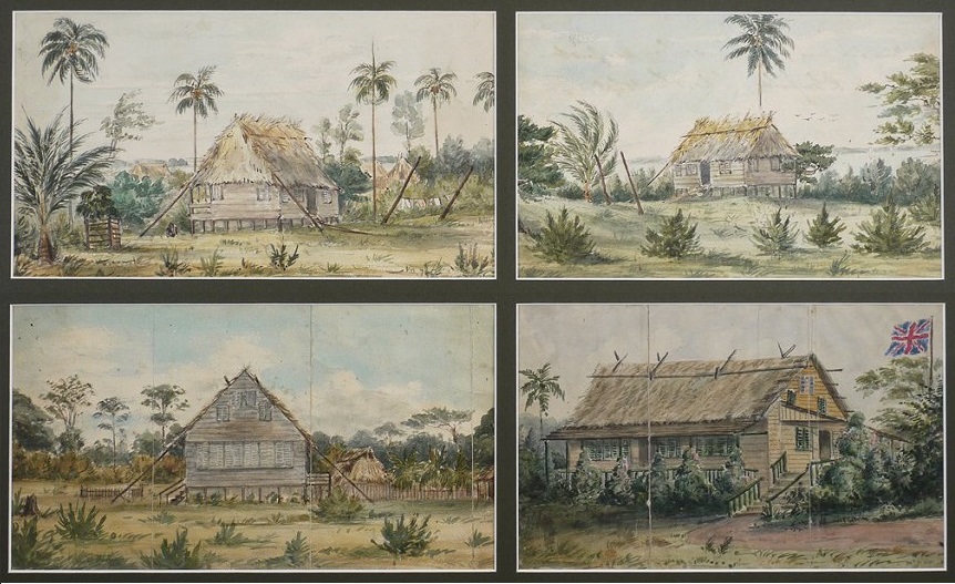
Poyais, Mahogany, and the Con Man's Paradise
The coast's loose sovereignty attracted opportunity seekers of every kind. Between 1820 and 1837, the Scottish con man Gregor MacGregor told investors in London and Paris that he had been named Cacique of Poyais by King George Frederic Augustus I. He sold forged land rights to hundreds of eager settlers who arrived expecting a developed colony and found instead unbroken jungle. Most died of tropical disease. The scheme ranks among the most audacious frauds in financial history. More legitimate but equally disruptive was the mahogany trade. As supplies in Belize dwindled, timber companies turned to the Mosquito Coast, acquiring cutting concessions from King Robert Charles Frederic. American capital flowed in alongside immigrants from the West Indies, Europe, Syria, and China. Britain formally recognized the Mosquito Kingdom as an independent state in 1837, using it as a buffer against the Central American republics that had emerged from the collapsing Federal Republic. The coast became a place where sovereignty was claimed by many and controlled by none.
The Treaty of Managua and the Reserve
In 1860, Britain and Nicaragua signed the Treaty of Managua, transferring suzerainty over the coast to Nicaragua while carving out an autonomous Miskito reserve around Bluefields. The kingdom's titles -- king, general, admiral, governor -- were abolished, replaced by a hereditary chief advised by a council of 41 elected members. George Augustus Frederic II accepted the diminished role in exchange for an annual payment of 1,000 pounds from the Nicaraguan government. On paper, the arrangement balanced indigenous autonomy with national sovereignty. In practice, it satisfied no one. Nicaragua resented the limits on its authority. The Miskito resented the loss of their independence. The British, who had agreed to step back, continued to meddle. For three decades the reserve functioned as a semi-autonomous zone, governed by a council that included Moravian missionaries alongside Miskito leaders, its flag incorporating symbols of Nicaraguan suzerainty that no one on the coast took seriously.
The End of Autonomy
In November 1894, Nicaraguan troops marched into Bluefields and militarily incorporated the Mosquito Coast into the republic. The autonomous reserve was abolished. For the Miskito, it was the final act in a centuries-long negotiation that had always been conducted from a position of declining leverage. The British protested but did not intervene. The northern portion of the coast, around Cabo Gracias a Dios where the Coco River splits Honduras from Nicaragua, remained disputed until 1960, when the International Court of Justice awarded it to Honduras. Today the region retains a distinct cultural identity. The Miskito language is still spoken, Moravian churches still anchor community life, and the Caribbean-facing lowlands still feel remote from the Pacific highlands where political power concentrates. The name itself endures -- not for the insects, which are plentiful, but for the Miskito people who gave the coast its identity long before any European flag flew over it.
From the Air
Centered at approximately 13.46N, 84.81W along the Caribbean coast of Nicaragua and Honduras. The coast stretches from Cabo Gracias a Dios in the north (where the Coco River meets the sea at the Honduras-Nicaragua border) southward past Bluefields. Dense tropical lowlands, lagoons, and river systems dominate the terrain. Nearest airports: MNBL (Bluefields), MNPC (Puerto Cabezas/Bilwi) along the coast, MNMG (Managua) inland. Best viewed at 15,000-25,000 feet to appreciate the vast, roadless lowland stretching from the Caribbean to the central highlands.