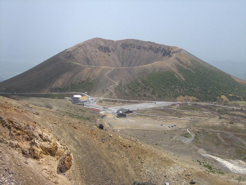
Mount Azuma-kofuji
Every spring, the people of Fukushima City look west toward the Azuma mountain range and wait for a rabbit. As snow melts from the flanks of Mount Azuma-kofuji, a white hare-shaped patch emerges on the dark volcanic slopes -- the 'seeding rabbit,' a natural signal that winter has released its grip and the farming season can begin. It is a fitting bit of poetry for a mountain whose very name is an act of admiration. 'Kofuji' means 'Little Fuji,' and from almost any angle the resemblance is uncanny: a lone, symmetrical cone rising to 1,707 meters, its wide crater yawning 500 meters across and 70 meters deep, a miniature replica of Japan's most sacred peak set among the wild highlands of Tohoku.
A Restless Landscape
Mount Azuma-kofuji is one peak within the broader Azuma volcanic group, a cluster of stratovolcanoes straddling the border between Fukushima and Yamagata prefectures inside Bandai-Asahi National Park. The Japan Meteorological Agency monitors the mountain continuously; fumaroles hiss and steam along the ridgelines, and the volcanic alert level has been raised to Level 2 on multiple occasions, restricting access to the crater area. The surrounding terrain bears the scars of deep geological violence. Nearby Mount Bandai erupted catastrophically on July 15, 1888, destroying dozens of villages and killing roughly 500 people. That eruption also created one of the region's most surreal attractions: Goshiki-numa, the Five Colored Lakes, a cluster of volcanic ponds whose waters shift from cobalt blue to emerald green to rust-red depending on mineral content, weather, and season.
The Skyline Above the Clouds
The Bandai-Azuma Skyline, a 28.7-kilometer mountain road selected as one of the 100 Best Roads in Japan, threads its way through the Azuma range at elevations up to 1,622 meters. Unlike many of Japan's scenic toll roads, this one is free. The midpoint is Jododaira, a sub-alpine plateau wedged between Mount Azuma-kofuji and neighboring Mount Issaikyo, where marshes and alpine wildflowers spread beneath the volcanic peaks. A visitor center at Jododaira offers parking, eateries, and a bus stop connecting to Fukushima Station below. From there, hikers can reach the crater rim of Azuma-kofuji in roughly ten minutes on a well-maintained trail. The road closes from mid-November through early April, when heavy snowfall blankets the highlands. When it reopens, drivers pass through corridors of snow towering on both sides -- the famous 'snow corridor' that draws visitors from across Japan.
Steam and Hot Water
Volcanic heat makes itself useful in the Azuma range. Fumaroles vent sulfurous steam at several points along the ridgeline, and the geothermal energy feeds a network of onsen -- hot spring baths -- scattered through the valleys below. The combination of accessible volcanic scenery and soothing mineral baths has made the area a tourist destination for generations. Visitors who hike the crater in the morning can soak in a rotenburo, an open-air bath, by afternoon, watching mist drift across the cedar-forested valleys. The Azuma volcanic group sits on the list of Japan's 100 Famous Mountains, a distinction that brings steady foot traffic from peak-baggers and casual hikers alike throughout the warmer months.
The Rabbit Returns
The snow rabbit of Mount Azuma-kofuji is not a legend or a folk tale -- it is a reliable meteorological event, one that farmers have watched for across centuries. As spring warmth eats away at the snowpack, exposed rock and vegetation form the outline of a crouching hare against the remaining white. When the rabbit appears fully formed, typically in late April or early May, it means soil temperatures have reached the threshold for rice planting. Fukushima City even uses the rabbit as an unofficial seasonal marker. The phenomenon is visible from across the Fukushima basin, no binoculars needed -- just a clear day and a westward glance toward the mountains. It is a reminder that in a landscape shaped by fire and eruption, the rhythms of agriculture still keep time by the shape of melting snow.
From the Air
Mount Azuma-kofuji is located at 37.72N, 140.26E, rising to 1,707 meters (5,600 feet). The symmetrical crater is a distinctive landmark from the air, especially with snow cover highlighting its conical shape. The Bandai-Azuma Skyline road is visible threading across the ridgeline. Nearest airports: Fukushima Airport (RJSF), approximately 60 km south, and Yamagata Airport (RJSC), approximately 70 km north. The volcanic group is within Bandai-Asahi National Park. Be aware of potential volcanic activity -- fumaroles are frequently active. Mountain weather can change rapidly; cloud cover and gusty winds are common at summit level. Best aerial views in clear conditions from 8,000-10,000 feet AGL, approaching from the east over the Fukushima basin.