Mount Baker
On a clear day, Mount Baker floats on the northern horizon like a vision - a perfect white cone rising 10,781 feet above the Puget Sound lowlands, visible from Seattle, Vancouver, and the deck of every ferry crossing the Salish Sea. The Lummi people called it 'Kulshan' - 'the broken one' - referring to the volcanic steam that sometimes rises from its crater. In 1999, Mount Baker claimed a record that still stands: 1,140 inches of snow in a single season, making it officially the snowiest place ever measured on Earth. This is a mountain of superlatives, of extremes, of beauty so dramatic it has defined the Pacific Northwest skyline since Captain George Vancouver first charted these waters in 1792.
The White Mountain
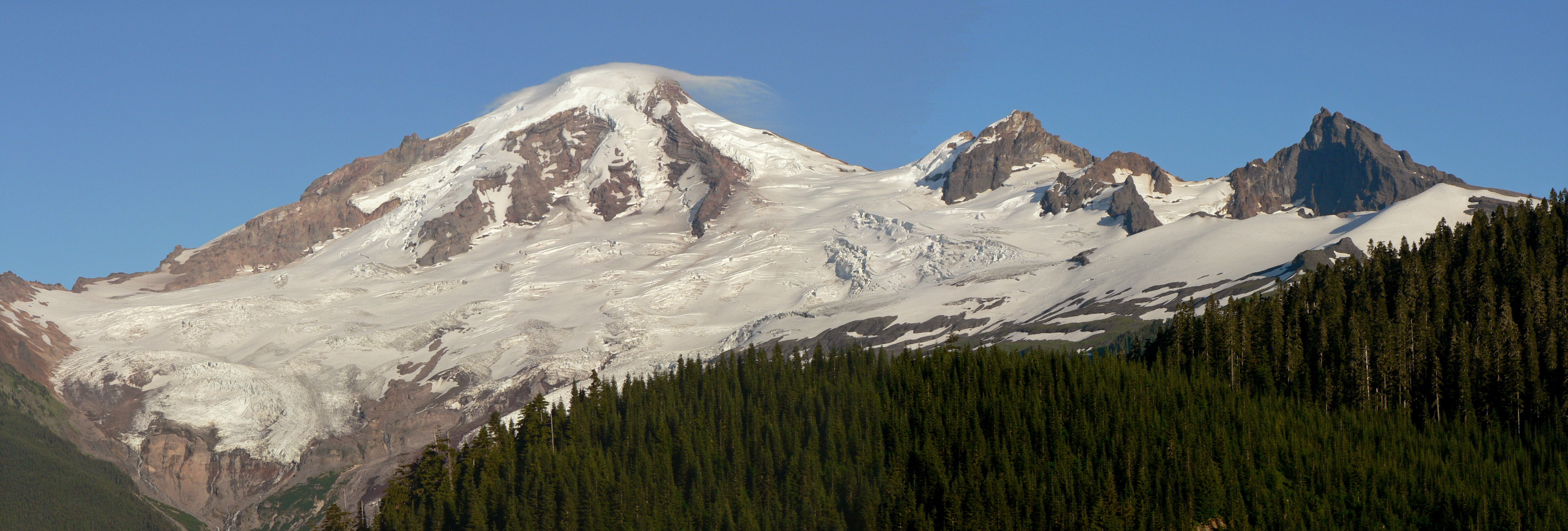
Mount Baker is one of the most heavily glaciated peaks in the Cascade Range, its flanks draped in permanent ice that feeds the rivers below. The glaciers - Roosevelt, Coleman, Deming, Easton, and others - cover over 28 square miles, flowing slowly down the volcanic cone into valleys that were carved by larger glaciers during the ice ages. Even in late summer, when other Cascade peaks show patches of bare rock, Baker remains buried in white.
The snowfall that feeds these glaciers is legendary. Storm after storm rolls in from the Pacific, rising over the Coast Range and releasing moisture as they hit Baker's mass. The ski area at Heather Meadows averages over 600 inches annually - fifty feet of snow - but the record season of 1998-99 nearly doubled that, burying lifts and buildings, closing the highway for weeks at a time. The snow doesn't fully melt until August in most years, and some seasons it never fully goes.
The Active Volcano
Mount Baker is not dormant. Steam vents in Sherman Crater melt ice and rock, maintaining a permanent warm zone near the summit. In 1975, increased thermal activity prompted fears of an imminent eruption; the mountain was closed to climbers while geologists monitored. The eruption never came, but the reminder was clear: Baker is alive, its last major eruption only 6,600 years ago, its last significant activity in 1880.
The volcanic hazard extends beyond eruption. Lahars - volcanic mudflows - have swept down Baker's valleys repeatedly in geologic time. The communities along the Nooksack River sit on lahar deposits. The risk is real enough that warning systems are in place, though generations may pass between events. For now, the steam vents merely add an otherworldly element to summit climbs, warm mist rising from snow-covered rock while climbers rest before their descent.
The Climber's Mountain
Mount Baker is where Pacific Northwest mountaineers learn their craft. The standard routes - Coleman Glacier, Easton Glacier - are challenging enough to require glacier travel skills but accessible enough to be achieved by fit beginners with proper training. Thousands of climbers summit each year, many of them preparing for attempts on Mount Rainier or peaks beyond. The mountain has become a graduation point, a test of whether you're ready for bigger objectives.
The climbing season runs from May through September, with the sweet spot in June and July when the snow is still consolidated but the days are long. Summit parties typically leave high camp around 2 AM, climbing by headlamp, timing their arrival at the crater rim for sunrise. The views from the top sweep from the Olympics to the Cascades to the Canadian Coast Range, a panorama of peaks and water that rewards the pre-dawn effort. By noon, the sun has softened the snow and rockfall increases; most parties are well down by then.
Artist Point and Beyond
You don't have to climb to experience Baker's magic. The Mount Baker Highway ends at Artist Point, 5,100 feet above sea level, where parking lots empty into trails with views that make photographers weep. Mount Shuksan rises across the valley - arguably the most photographed peak in the Pacific Northwest, its pyramidal form reflected in alpine tarns on calm mornings. Mount Baker itself looms behind you, massive and close.
The hiking options range from gentle loops to demanding ridge traverses. The Chain Lakes Trail circles through meadows and past small lakes. Table Mountain offers scrambling to a flat summit with panoramic views. Ptarmigan Ridge leads toward the glacier's edge. And in winter, when the road closes, the area becomes a backcountry skiing paradise, accessed by snowshoe or ski from whatever point the snowplows have reached.
Heather Meadows
The ski area at Heather Meadows is an anachronism - a small, family-oriented resort in an age of corporate mega-resorts. There are no high-speed lifts, no slopeside condos, no crowds. What there is: steep terrain, deep powder, and views that rival any ski area on the continent. The chairlifts rise through a landscape of stunted subalpine fir, the trees bent and twisted by the wind and snow into surreal forms called 'snow ghosts.'
The season runs from November into April most years, though the mountain has seen lift-served skiing as late as June when the snowpack allows. The vibe is old-school - cash preferred at the food counters, lift tickets cheaper than anywhere comparable, locals who have been skiing here for generations. It's not a destination resort; it's a local's mountain, cherished by Bellingham and the surrounding communities as their own backyard winter playground.
From the Air
Located at 48.78°N, 121.81°W. Mount Baker is unmistakable - a massive, heavily glaciated volcanic cone rising 10,781 feet, the northernmost of Washington's major Cascade volcanoes. Visible from Seattle (90nm south), Vancouver (75nm north), and throughout the Puget Sound region. Look for the distinctive rounded summit with extensive glacier coverage; Sherman Crater may show steam on clear days. Mount Shuksan (9,131 ft) rises prominently to the east - a dramatic pyramid that is often photographed with Baker. The ski area and Artist Point parking lot are visible at treeline on the east side. The Mount Baker Highway (SR-542) is the only road approach. Nearest airports: Bellingham International (KBLI) 35nm west, Lynden (38W). Heavy cloud and icing common; the mountain generates its own weather.