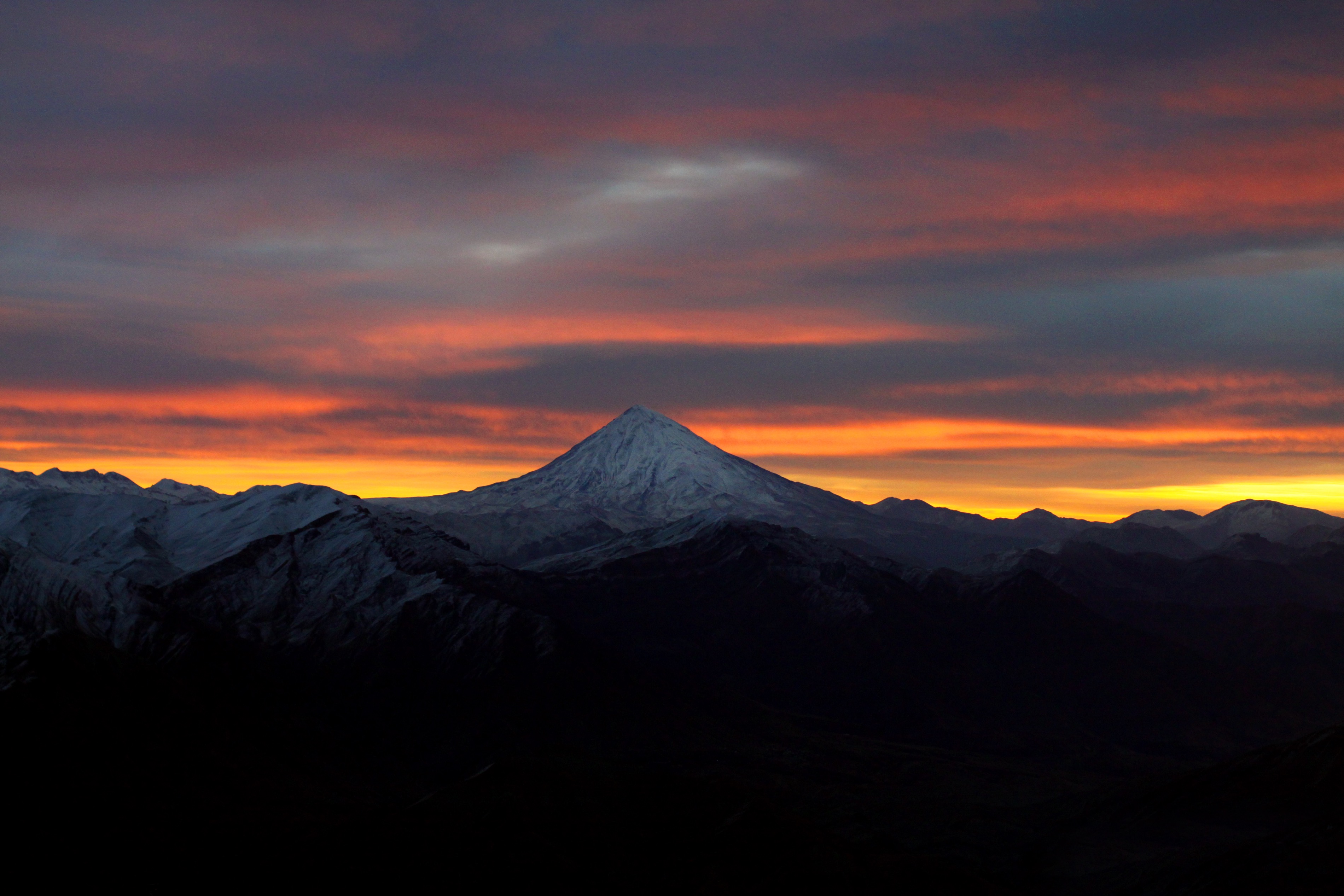
Mount Damavand
"O white giant with feet in chains, O dome of the world, O Damavand." The poet Mohammad Taqi Bahar addressed the mountain as though it were alive, and standing at its base, the impulse is understandable. Mount Damavand rises 5,609 meters out of the Alborz range in northern Iran, the highest peak in Western Asia and the highest volcano on the Asian continent. It is visible from Tehran on clear days, a lone white cone floating above the smog line, 66 kilometers to the northeast. The name may mean "the mountain from which smoke and ash arises," a reference to the fumaroles that still vent sulfurous gas near the summit -- proof that this dormant stratovolcano is sleeping, not dead.
The Dragon's Prison
No mountain in Iran carries more mythological weight. In Zoroastrian texts, the three-headed dragon Azi Dahaka was defeated and chained within Damavand, imprisoned there until the end of the world. A later version of the legend substitutes the tyrant Zahhak, overthrown by the blacksmith-hero Kaveh and the prince Fereydun, then locked away in a cave somewhere inside the mountain's vast bulk. The Shahnameh, Ferdowsi's epic poem of Persian kings and heroes, attributes magical powers to Damavand. In the legend of Arash, the hero climbed to the summit and shot a magical arrow to mark the border between Iran and Turan, pouring his entire life force into the shot. The arrow flew for days. These are not quaint folk tales relegated to children's books. Damavand appears on the reverse of Iran's 10,000-rial banknote. It is the 12th most prominent peak in the world and part of the Volcanic Seven Summits mountaineering challenge. Mythology and national identity are fused into the geology itself.
Fire Beneath the Ice
Volcanic activity in the Damavand region began during the Pleistocene, almost 1.78 million years ago, but the current edifice started forming roughly 600,000 years ago. The last eruption occurred around 5300 BCE. Its steep cone is built from layers of ash and lava -- primarily trachyte, andesite, and basalt -- though one major explosive event about 280,000 years ago left pyroclastic flow deposits in drainages radiating from the summit. The volcano is not extinct. A small summit crater vents sulfuric gases, and the area around Damavand is the most thermally active in Iran. Hot springs at the base and on the flanks, combined with fumaroles near the top, indicate a hot or cooling magma body still present beneath the mountain. Between 2003 and 2008, scientists measured subsidence at 5 millimeters per year and horizontal expansion at 6 millimeters per year, though this movement was attributed to gravity rather than rising magma. The springs are monitored for fluctuations that might help predict regional earthquakes.
Waters That Heal
The Larijan Hot Spring, in the Lar Valley on Damavand's flanks, is the most famous of the mountain's thermal features. Its mineral-rich water is believed to treat chronic wounds and skin diseases, and it is bottled for distribution across Iran. Public baths with small pools serve visitors who come for the water's reputed curative properties. The thermal springs are not merely curiosities. They mark the boundary between the mountain's volcanic interior and the landscape it sustains. During the Last Glacial Maximum, glaciation covered a far larger area, and the climatic snow line sat 600 meters or more below its present position. The glaciers that remain on Damavand, along with a few other isolated locations, feed some of Iran's only permanently flowing rivers. Water descends from ice fields through valleys where brown trout swim in cold streams -- a startling ecological detail for a country dominated by desert.
Leopards, Snowcocks, and Poppies
Damavand's ecological range is extraordinary. Persian leopards and Syrian brown bears inhabit the mountain's middle slopes alongside Armenian mouflon and wild goats. At higher elevations, the Caspian snowcock nests among rocks, while golden eagles breed on the cliffs and griffon vultures ride thermals above the ridgelines. Migratory birds arrive seasonally: nightingales and rock thrushes from Africa in spring, grey-necked buntings and common rosefinches from India. The flora shifts with altitude and aspect. Southern slopes hold remnants of wild pistachio trees. Northern slopes, catching more moisture from the Caspian, support Persian oak, Oriental beech, and Turkish hazel. From mid-May to mid-June, the foothills blaze with red poppies. Higher still, vegetation compresses into cushion-shaped shrubs -- astragalus, mountain sainfoin, spiny acantholimon -- adapted to wind and cold. An iris subspecies, Iris barnumiae demawendica, exists nowhere else and takes its name from the mountain.
Sixteen Routes to the Dome
At least sixteen known routes lead to Damavand's summit, ranging from straightforward trekking to technical ice climbing. The most popular is the southern route, which features stone steps and a midway shelter called Bargah Sevom at 4,220 meters. The village of Polour, on the mountain's southern side, serves as the main staging area, home to the Iranian Mountain Federation Camp. The northeastern route is the longest, requiring two days from the village of Nandal with an overnight stay at Takht-e Fereydoun, a two-story shelter at 4,300 meters -- a name that translates to the Throne of Fereydun, the legendary prince who chained Zahhak inside the peak. The western route draws climbers for its sunset views. Near the Simurgh shelter at 4,100 meters -- named for the mythical bird of Persian legend -- a frozen waterfall stands about 12 meters tall. Even the approach to the summit is layered with the stories that make Damavand more than a mountain. It is, as Bahar wrote, the dome of the world.
From the Air
Mount Damavand is located at 35.95N, 52.11E in the Alborz range, 66 km northeast of Tehran. At 5,609 meters (18,402 feet), it is a dominant visual landmark from any flight over northern Iran. The snow-capped volcanic cone is visible from Tehran on clear days. The nearest airports are Tehran Imam Khomeini International (OIIE) and Mehrabad (OIII). From cruising altitude, the Alborz range separates the green Caspian lowlands to the north from the Iranian plateau to the south, with Damavand rising as the chain's highest point. Exercise caution regarding terrain clearance and mountain weather. Turbulence is common near the range.