Mount Fuji Radar System
In September 1959, Typhoon Vera slammed into Japan with winds exceeding 300 kilometers per hour, killing more than 5,000 people and injuring nearly 40,000. The Isewan Typhoon, as it became known, was the deadliest to ever make landfall on Japan. In its aftermath, the national outcry was clear: if there had been a better warning system, thousands might have lived. The response was audacious -- build a weather radar on the summit of Mount Fuji, 3,776 meters above sea level, the highest point in the country. From up there, the system could see typhoons forming more than 800 kilometers away, buying precious hours of warning time. Completed on August 15, 1964, the Mount Fuji Radar System became the world's highest weather radar and one of the great engineering achievements of postwar Japan.
500 Tons to the Top of Japan
Building anything at 3,776 meters is brutal. Building a precision radar installation there borders on the absurd. Yet the Japan Meteorological Agency and Mitsubishi Electric Corporation did exactly that, hauling approximately 500 tons of material to Fuji's summit during the mountain's brutally short summer construction windows. The logistics alone were staggering: every steel beam, every cable, every bolt had to be transported up a mountain famous for violent weather, high winds, and oxygen-thin air. Construction began in June 1963, and the installation was completed just over a year later. The result was a system that earned a place on the list of IEEE Milestones in electrical engineering -- recognition reserved for achievements that have changed the world.
The Machine on the Mountain
The radar system operated at 2,880 MHz, pumping out 1,500 kilowatts of power with a pulse width of 3.5 microseconds. Its antenna was a 5-meter parabolic dish that rotated at either 3 or 5 revolutions per minute, all enclosed within a 9-meter radome designed to withstand Fuji's extreme conditions. The system could detect major weather phenomena -- particularly the typhoons that terrorized Japan's coastal cities -- at distances exceeding 800 kilometers. In an era before weather satellites provided continuous coverage, this radar was Japan's early warning shield, perched at the very top of the nation. Remote-control technology allowed operators to run the system from lower elevations, a necessity given that Fuji's summit is uninhabitable for extended periods.
Thirty-Five Years of Vigilance
From 1964 to 1999, the Mount Fuji Radar System stood watch. For 35 years, it tracked typhoons as they churned across the western Pacific, providing critical lead time for evacuations and preparations along Japan's vulnerable coastlines. The system represented the direct answer to the Isewan tragedy -- a technological monument to the principle that forewarning saves lives. But by the late 1990s, weather satellites had matured to the point where they could provide equivalent or superior coverage from orbit. Ground-based radar at extreme altitude was no longer necessary. The system was decommissioned in 1999, and an automated weather station replaced it on October 1, 2008.
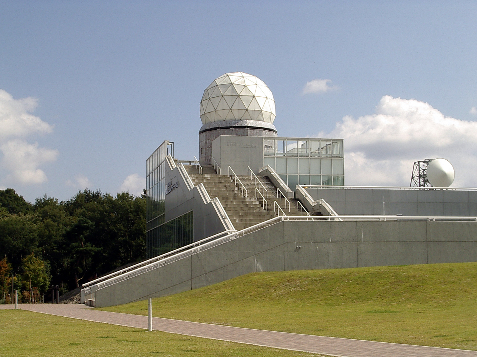
A Dome Comes Down the Mountain
Rather than abandoning the hardware on the summit, the dome, radar dish, and support equipment were carefully disassembled and transported back down Mount Fuji. In 2001, they were installed in a purpose-built museum in the city of Fujiyoshida, at the mountain's northern base. The Mt. Fuji Radar Dome Museum allows visitors to see the actual equipment that once sat at Japan's highest point, complete with exhibits explaining the construction challenges and the typhoon-tracking mission. Standing inside the relocated radome, you can grasp the scale of what was accomplished: a five-meter antenna dish, engineered to survive conditions that defeat most structures, carried to the roof of Japan and kept running for more than three decades.
From the Air
The original radar installation was located at 35.4578N, 138.8038E on the summit of Mount Fuji (3,776 meters / 12,388 feet). The summit radome is no longer present, but the mountain itself is unmistakable from any altitude. The Mt. Fuji Radar Dome Museum is now located in Fujiyoshida at the mountain's northern base. Nearest airports include RJTO (Oshima) and RJTF (Chofu), with RJTT (Tokyo Haneda) approximately 100 km to the northeast. Caution: Mount Fuji generates significant turbulence and wave activity. Lenticular clouds frequently form over the summit, and winds can exceed 100 knots at altitude. Maintain safe clearance when overflying.