Mount Khajeh
Zoroastrian scripture says that when the world nears its final renewal, maidens will wade into Lake Hamun and give birth to the saoshyans -- the saviors of humankind. The lake that holds this prophecy has been shrinking for decades, sometimes disappearing entirely into the dust of the Sistan Basin. But the black basalt hill at its center remains. Mount Khajeh, the only natural elevation in the vast Sistan plain, rises 609 meters above sea level like a dark altar set in an expanse of pale sediment and intermittent water. On its slopes, Zoroastrian fire temples, Sassanid murals, and the Islamic tomb of Khwaja Ali Mahdi crowd together in a compressed archive of Iranian spiritual history spanning more than two thousand years.
The Keeper of Zoroaster's Seed
Lake Hamun occupies a strange place in Zoroastrian cosmology. The Avestan texts describe it as the repository of Zoroaster's seed, preserved in the waters for the end of days. This is not metaphor tucked into a minor footnote -- it is central to Zoroastrian eschatology, the belief that three saviors will be born from the lake at intervals to prepare humanity for the final renovation of existence. The mountain rising from these prophetic waters became sacred by association, and a fire temple was built on its southern promontory during the pre-Islamic period. The ruins of that temple still stand within the citadel complex known as Ghagha-Shahr, their stone walls oriented toward a faith that once dominated an empire stretching from Mesopotamia to the Indus Valley.
Murals in the Dust
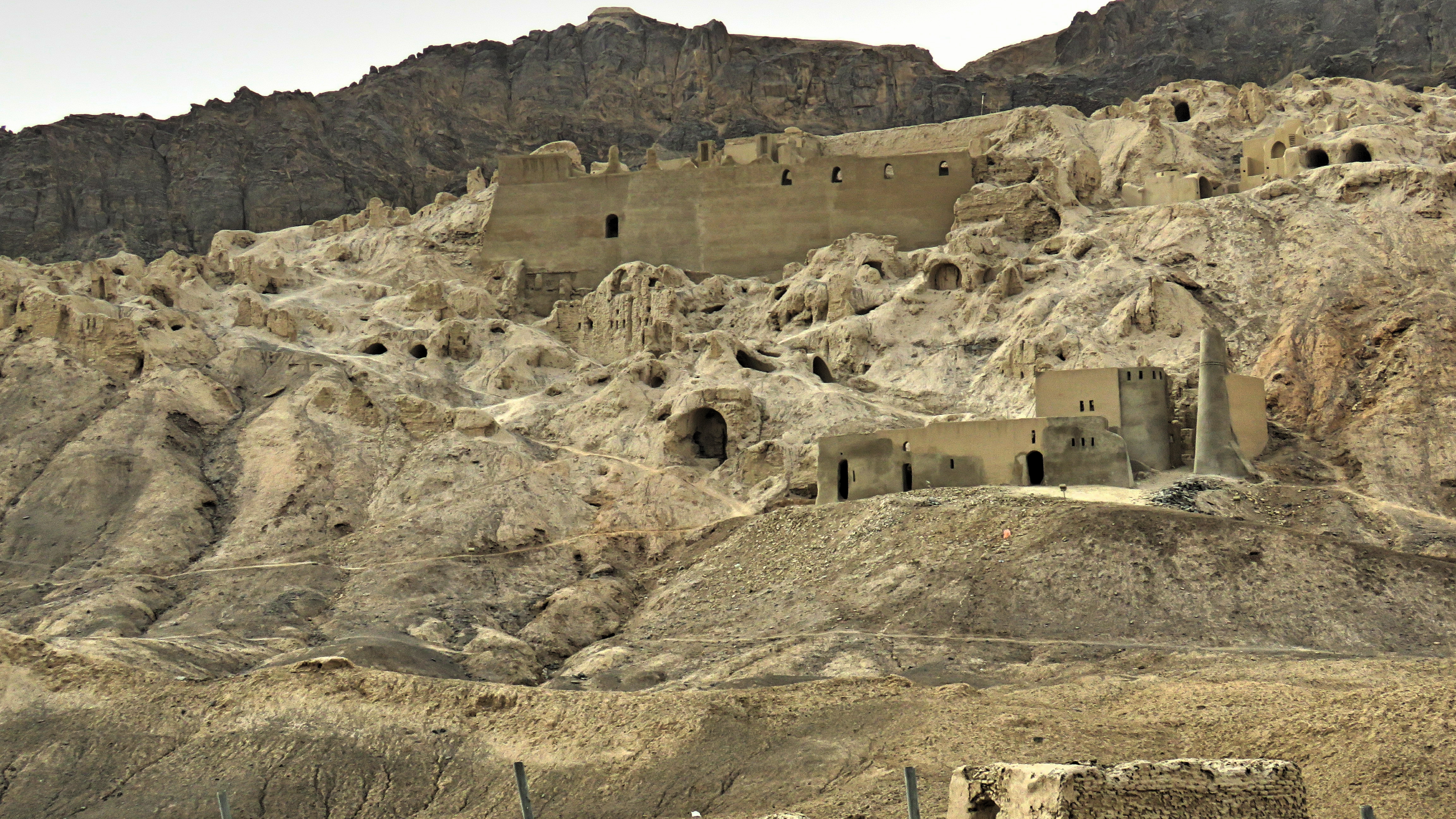
When the archaeologist Marc Aurel Stein reached Mount Khajeh in 1915, he found something unexpected on the walls of Ghagha-Shahr: painted murals, faded but discernible, depicting figures and scenes that suggested a sophisticated artistic tradition. Ernst Herzfeld followed with more thorough excavations and initially dated the palace complex to the Arsacid period, around the 1st century CE. He later revised his estimate. Today scholars generally attribute the citadel and its artwork to the Sassanid period, roughly 224 to 651 CE. Three bas-reliefs carved into the outer walls depict riders and horses in the stylized manner characteristic of Sassanid royal art. The murals themselves -- painted on plaster in a vaulted passage -- show figures that blend Iranian, Central Asian, and possibly Greco-Buddhist influences, a meeting point of cultures along the ancient trade routes that threaded through Sistan. Giorgio Gullini conducted a brief investigation in 1960, and the Herzfeld papers, including his drawings and maps, are now preserved at the Smithsonian Institution in Washington, D.C.
An Island Between Empires
Mount Khajeh's strategic value was simple: it was the only defensible high ground in an otherwise flat, marshy basin that straddled the border region between Iran and Afghanistan. The trapezoid-shaped basalt outcropping, located 30 kilometers southwest of the town of Zabol, measures between 2.0 and 2.5 kilometers in diameter. Its flat top provided a natural plateau for construction, and the surrounding lake -- when it held water -- served as a moat. Beyond the Ghagha-Shahr citadel on the summit, several other buildings of uncertain function dot the plateau, probably dating to the Islamic period. The hill's name itself comes from its most prominent Islamic feature: the tomb and shrine of Khwaja Ali Mahdi, a descendant of Ali ibn Abi Talib, the cousin and son-in-law of the Prophet Muhammad. Pilgrims have climbed the basalt slopes for centuries, their footsteps layered over those of Zoroastrian priests and Sassanid soldiers.
A Lake That Remembers and Forgets
The Sistan Basin is fed primarily by the Helmand River, which flows west from the Afghan highlands into a series of shallow lakes collectively called Hamun. In wet years, the water surrounds Mount Khajeh completely, restoring its island character and the eerie beauty of dark volcanic rock floating on bright, shallow water. In drought years -- which have grown more frequent -- the lake recedes or vanishes entirely, leaving the mountain stranded on cracked mud flats thick with dust. Climate change, upstream damming in Afghanistan, and shifting water-management politics have made the lake's future uncertain. For the communities in Zabol and surrounding villages, the drying of Hamun means the loss of fisheries, grazing land, and a way of life that has persisted since antiquity. For Mount Khajeh, it means the slow transformation from island sanctuary to desert butte, a place where prophecy waits on a lake that may not return.
From the Air
Mount Khajeh sits at 30.94N, 61.24E in the Sistan Basin of far eastern Iran, near the Afghan border. From altitude, look for a distinctive dark basalt mesa surrounded by the pale sediments and intermittent waters of Lake Hamun. The town of Zabol lies 30 km to the northeast. The nearest airport is Zabol Airport (OIZB). The terrain is extremely flat aside from the mountain itself, making it a striking visual landmark. Visibility can be severely reduced by dust storms common in the Sistan region, especially in summer months.