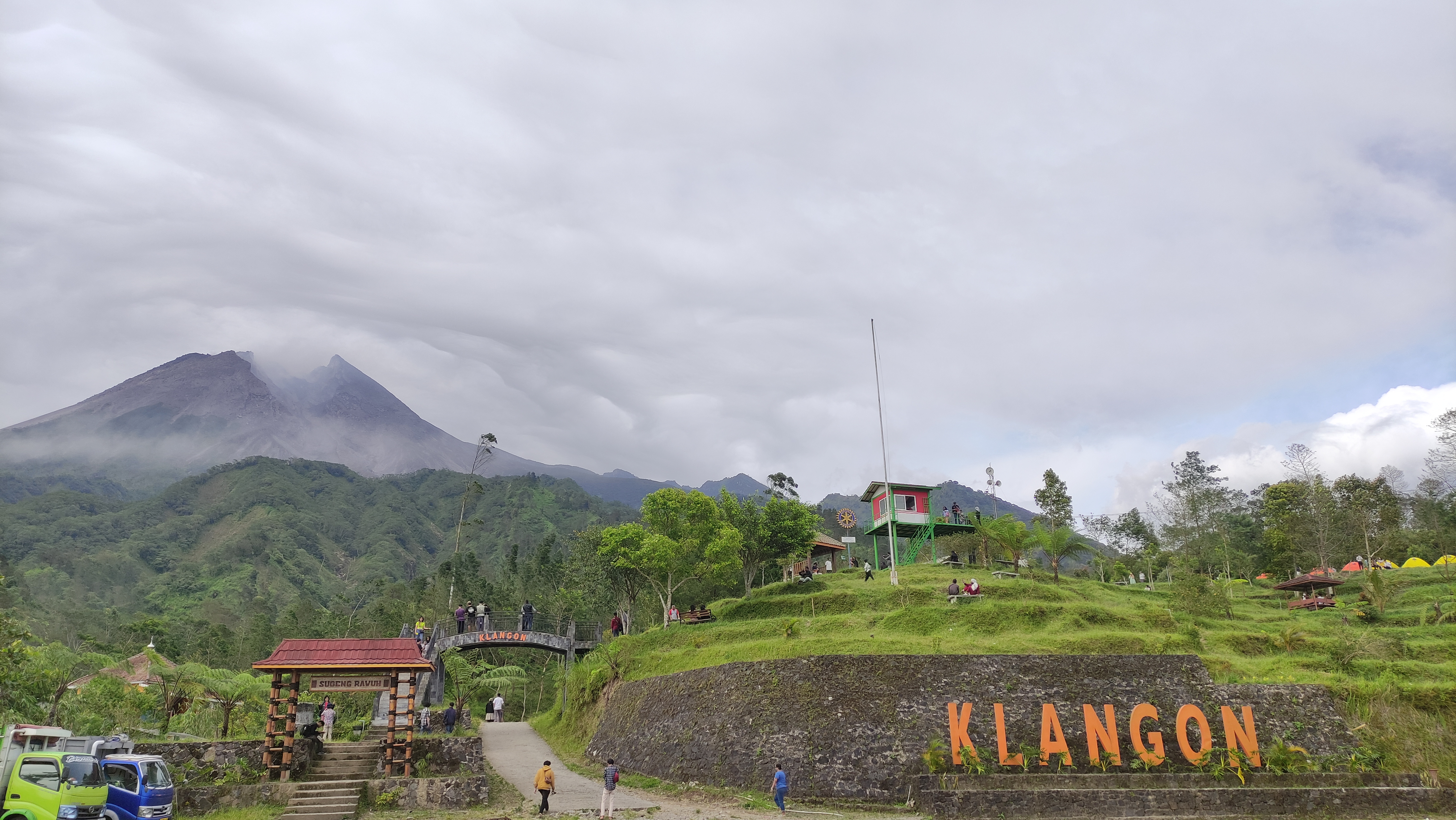
Mount Merapi
The name translates twice and means the same thing both ways. In Sanskrit, Meru is mountain; in Javanese, api is fire. Mount Merapi -- the Mountain of Fire -- has earned that redundancy through five centuries of unbroken volcanic activity. Rising from the border between Central Java and the Special Region of Yogyakarta, Merapi is the most active of Indonesia's 129 active volcanoes, erupting on average every two to three years with small events and every decade or so with something far worse. Yogyakarta, a city of 2.4 million, sits just 30 kilometers to the south. Thousands of people farm the volcano's flanks, living in villages perched as high as 1,700 meters on slopes that could become rivers of superheated gas and rock at any time.
Fire Forged in Deep Time
Merapi is the youngest in a chain of volcanoes across southern Java, born where the Indo-Australian plate dives beneath the Sunda plate along one of the most active subduction zones on Earth. It sits squarely in the southeastern arc of the Pacific Ring of Fire. The geological record tells a story of relentless violence: notable eruptions in 1006, 1786, 1822, 1872, and 1930, each leaving its own mark on the landscape and the people living in its shadow. The 1006 eruption may have blanketed all of central Java in ash, and some historians have linked it to the collapse of the Hindu Kingdom of Mataram, though the evidence remains debated. The 1930 eruption was more precisely documented -- thirteen villages destroyed, 1,400 people killed by pyroclastic flows. Designated as one of the world's sixteen Decade Volcanoes for its combination of destructive history and proximity to dense population, Merapi is among the most studied and most feared mountains on Earth.
Shaggy Goats and Shaking Ground
Merapi's eruptions follow a grim pattern: dome growth, inflation, tremors, then collapse. Lava builds up in a dome at the summit until the structure becomes unstable and collapses, sending pyroclastic flows cascading down the flanks. The Javanese call these flows wedhus gembel -- 'shaggy goat' -- for their billowing, tumbling clouds of superheated gas and debris. They can travel at highway speeds, incinerating everything in their path. In 2006, a bulge in the volcano's cone signaled fresh trouble, and by May lava flow was constant. Seventeen thousand people were ordered to evacuate, though many defied the order to protect livestock and crops. Then a magnitude 6.3 earthquake struck 50 kilometers to the southwest, killing over 5,000 people in the Yogyakarta region and raising fears that the quake would trigger a catastrophic eruption. The dual disaster of quake and volcano in a single season tested the region to its limits. The 2010 eruptions proved even worse, killing 386 people in the volcano's largest event since 1872.
Listening to the Mountain
Seismic monitoring at Merapi began in 1924, making it one of the longest-watched volcanoes in the world. The Babadan, Selo, and Plawangan observation posts have been rebuilt, relocated, and re-equipped across generations -- the 1930 eruption destroyed several pre-existing stations, and the 1994 eruption forced the Plawangan post to retreat downhill to Kaliurang for the safety of the volcanologists themselves. Today, a network of eight seismographs encircles the mountain, allowing scientists to pinpoint the hypocenters of tremors and map the magma reservoir lurking about 1.5 kilometers below the summit. Tilt meters track the inflation of the volcano as its magma chamber fills; magnetometers detect subtle shifts in the local magnetic field that precede eruptions. Even the rain is measured: about 50 millimeters per hour is the threshold above which lahars -- mudflows of pyroclastic material and water -- begin pouring down the riverbeds. After the 2010 catastrophe, the government declared nine villages in Cangkringan district a permanent sterile zone, and roughly 90 of the 258 sabo dams meant to channel volcanic debris were found to be damaged.
The Spirit Palace Inside the Mountain
For the Javanese, Merapi is not merely a geological hazard -- it is a living presence at the center of a sacred cosmology. According to local mythology, two legendary armourers, Empu Rama and Empu Permadi, were buried alive when the gods moved a mountain to balance the island of Java. Their spirits became the rulers of all mystical beings in the region, presiding over a kraton -- a spirit palace -- said to exist inside the volcano itself, mirroring the Yogyakarta Sultanate with its own roads, soldiers, and princes. Merapi forms the northern anchor of a sacred axis that runs south through the Tugu Yogyakarta monument, down Malioboro street, through the sultan's palace, and all the way to the Indian Ocean, where Nyi Roro Kidul, the queen of the Southern Sea, holds mythical court. To keep the volcano quiet, offerings are carried up the slopes on the anniversary of the sultan's coronation -- a ritual negotiation between human authority, mountain spirits, and ocean deity that has continued for centuries.
Living With the Mountain of Fire
Merapi has not slowed down. Eruptions in 2018, 2021, 2023, and 2024 each forced evacuations, each time reminding the region that the volcano operates on its own schedule. A 6,410-hectare national park established around the mountain in 2004 has itself become contested ground -- during the 2006 eruption, some residents refused to evacuate because they feared the government would use the crisis to confiscate their land for park expansion. The Merapi Museum Center at Kaliurang documents the mountain's destruction with a replica of its post-2010 landscape, and student visits have increased by 30 percent since the latest eruptions. But the most telling statistic about Merapi is the simplest one: despite everything, people come back. The volcanic soil is extraordinarily fertile, the cultural ties span centuries, and the mountain that kills also provides. This is the bargain that millions of Javanese have struck with the Mountain of Fire, and it is one they renew with every planting season.
From the Air
Mount Merapi rises to approximately 2,930 meters at 7.54S, 110.45E on the border of Central Java and the Special Region of Yogyakarta. The stratovolcano's conical peak is a prominent visual landmark, frequently trailing smoke or steam. Yogyakarta's Adisucipto International Airport (ICAO: WARJ) is roughly 30 km south; Adisumarmo International Airport (ICAO: WARQ) at Solo is about 35 km east. The 9th-century Prambanan temple complex is visible to the southeast, and Borobudur lies approximately 30 km to the west-southwest. Check NOTAMs for volcanic ash advisories. At lower altitudes, the river valleys radiating from the summit -- Gendol, Krasak, Boyong, Woro -- are visible channels for pyroclastic flows and lahars.