Mount Myogi
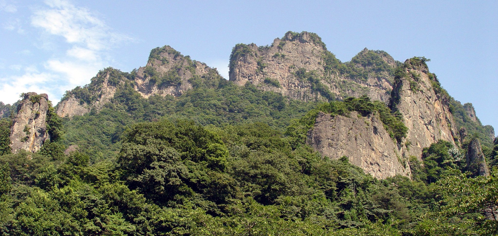
The rocks have names. Candle Rock. Cannon Rock. Shaky Rock. Nihilist Monk Rock. They rise from the flanks of Mount Myogi like the ruins of some impossible cathedral, columns and spires of volcanic stone worn into shapes that have inspired reverence, terror, and -- more recently -- a famous anime street racing series. At 1,104 meters, Myogi is not a particularly tall mountain. But what it lacks in height it makes up for in sheer drama. Designated as one of Japan's Three Great Rare Scenic Beauties and selected among the 100 Landscapes of Japan, this jagged massif in Gunma Prefecture looks less like a mountain than a sculpture garden carved by three million years of erosion.
A Mountain of Many Peaks
Mount Myogi is not a single summit but a constellation of them. Hakuun-zan, the White Cloud Mountain. Kondo-san, the Golden Cave. Kinkei-san, the Golden Rooster. The highest, Soma-dake, reaches 1,104 meters. The mountain is generally divided into its front side, facing south toward the towns, and its back side, facing north into wilder terrain. The most visually striking section is Nakano-take, a wall of fantastically shaped rock formations along the southern slope that earns Mount Myogi its reputation. The geology tells the story: three million years ago, a volcanic caldera produced layers of dacite, tuff, and conglomerate. Over the millennia, softer sedimentary layers eroded away, leaving behind the harder volcanic rock in its current jagged, tooth-like formations. The result is a mountain that looks perpetually unfinished, as though the earth started building something and then changed its mind.
Sacred Stone, Ancient Protector
Myogi Shrine sits on Hakuun-zan, the east slope of the mountain, its vermillion torii gate framing the rock spires above. The shrine has stood here for centuries, and during the Edo period, the people of the surrounding villages believed that the god of Mount Myogi protected them from fire and lightning -- no small thing in a land of wooden houses and summer storms. On the opposite side of the mountain, Nakano-dake Shrine marks the beginning of the hiking trail that threads through the most dramatic rock formations. Mount Myogi is one of the Three Mountains of Jomo -- alongside Mount Akagi and Mount Haruna -- a trinity so central to Gunma's identity that the mountains appear on the Jomo Karuta, a traditional card game that teaches children about the prefecture's landmarks. The name 'Myogi' carries such weight locally that the dormitories of the UNESCO World Heritage Tomioka Silk Mill, registered in 2014, are named after these three mountains.
Chains, Cliffs, and Consequences
Myogi's beauty comes with a body count. The same jagged formations that draw photographers and pilgrims have produced severe hiking accidents and deaths over the years. The trails range from gentle forest walks to exposed cliff traverses that require climbing chains bolted into bare rock, with drops of hundreds of meters on either side. In January 2010, the situation prompted an emergency summit: Gunma prefecture officials, police, firefighters, and local hiking clubs gathered for what was formally titled the 'Meeting for the establishment of preventive measures to avoid accidents in Mount Myogi and surrounding mountains.' The officials proposed banning hiking altogether. The locals refused. In the end, a compromise was reached: more chains would be installed, routes would be better marked, and courses would be formally classified for beginners, intermediates, and experienced climbers. The mountain would remain open, but it would no longer pretend to be safe.
Night Kids Territory
For a generation raised on manga and anime, Mount Myogi means one thing: the home turf of the Myogi Night Kids. In the street racing series Initial D, the mountain's serpentine roads serve as the battleground for four pivotal races, its hairpin turns and steep grades perfectly suited to the drifting culture that the series celebrates. The real Keiichi Tsuchiya, the legendary drift racer who inspired the series, actually honed his skills on the mountain roads of this region. It is a fitting tribute to a mountain that has always been about drama -- whether geological, spiritual, or at high speed through the autumn fog. Mount Fuji may be visible to the south on clear days, serene and symmetrical, but Myogi offers the opposite: a landscape of chaos and character, where every angle reveals a new silhouette against the sky.
From the Air
Located at 36.30N, 138.75E in Gunma Prefecture. The jagged rock formations are unmistakable from the air, rising sharply from forested slopes. Mount Myogi straddles the border of Annaka, Shimonita, and Tomioka municipalities. On clear days, Mount Fuji is visible to the south and Mount Asama to the northwest. The Joshin-etsu Expressway runs along the base of the mountain. Nearest airports: Matsumoto Airport (RJAF) approximately 90nm west, Tokyo Haneda (RJTT) approximately 65nm southeast. Recommended viewing altitude: 5,000-7,000 feet AGL to appreciate the rock formations. Be aware of turbulence and updrafts near the ridgeline, especially in afternoon thermal conditions.