Mount Nasu: Five Peaks and Infinite Hell
The sulfur hits you before the summit does. Rising from the Nasu Highlands in the northeastern corner of Nikko National Park, a cluster of volcanic peaks collectively known as Nasu-dake has been venting heat and toxic gas for 600,000 years. Only one summit remains active today -- Chausu Peak, whose crown of fumaroles still pushes sulfurous gases at temperatures reaching 90 degrees Celsius through cracks in the andesite. The Japanese call this field of hissing vents Mugen Jigoku: Infinite Hell. It is an apt name for a place where the poet Matsuo Basho once noted that dead butterflies and bees lay so thick on the ground you could not see the sand beneath. Yet the same volcanic violence that produces Infinite Hell also feeds more than 150 hot springs across the Nasu Highlands below, making this landscape one of Japan's great contradictions -- a place that kills and heals in equal measure.
The Five Peaks of Nasu
The Nasu volcanic group -- known collectively as Nasu Go-dake, the Five Peaks of Nasu -- forms a line of summits running roughly north to south. Sanbonyari Peak stands tallest at 1,917 meters, edging out Chausu at 1,915 meters by the slimmest of margins. Asahi Peak follows at 1,896 meters, with Minamigatsusan at 1,776 meters and Kuro-oya Peak at 1,589 meters rounding out the group. Together they create the volcanic backbone of the northern Nikko National Park, listed among the 100 Famous Japanese Mountains. The peaks sit at the boundary of Tochigi and Fukushima Prefectures, their ridgelines marking the transition from the Kanto plains to the rugged Tohoku interior. From the summits on clear days, the view stretches across forested highlands and river valleys in every direction.
A Volcano Still Breathing
Chausu Peak began erupting roughly 16,000 years ago, building itself through successive layers of lava and ash. Its most violent episode came between 1408 and 1410, when sustained eruptions formed the hardened andesite dome that shapes the summit today and reportedly killed more than 180 people. The mountain's most recent eruption occurred in 1881, but the volcano has never truly gone quiet. Sulfurous steam rises daily from the summit fumaroles, and the Japan Meteorological Agency maintains continuous monitoring stations on the peak. The volcanic activity that makes Chausu dangerous also created the landscape around it -- the mineral-rich soils support dense forests of Japanese beech and Mongolian oak on the lower slopes, while the upper elevations are carpeted with alpine shrubs and dwarf bamboo that turn brilliant shades of crimson and gold each October.
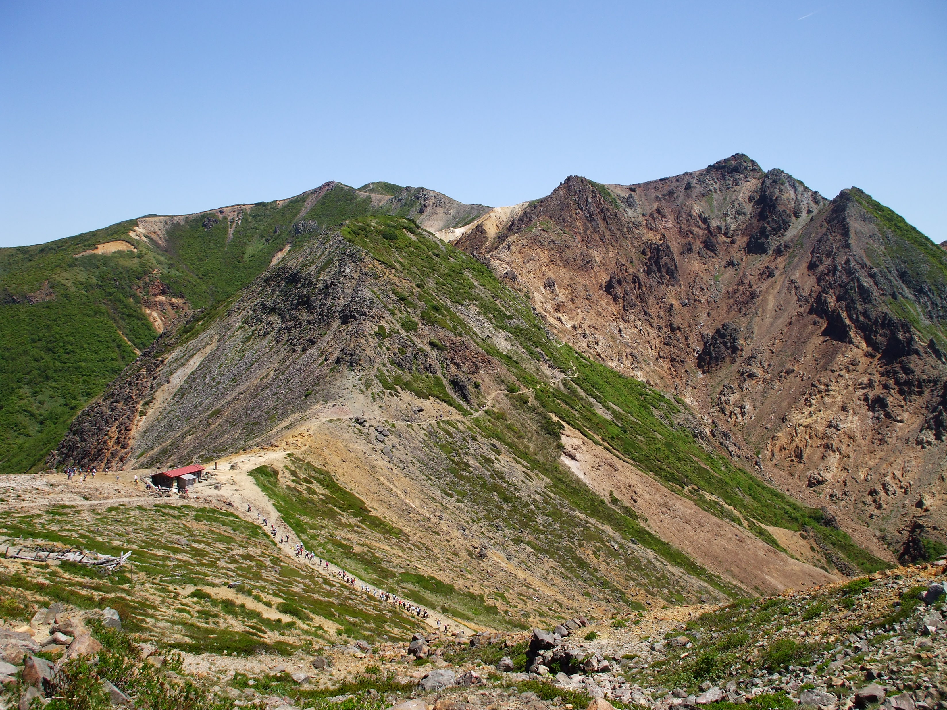
Riding the Ropeway to the Clouds
The Nasu Ropeway carries visitors from a parking area near the mountain's base up to the Ninth Station on Chausu's flank, a ride that covers roughly 800 meters of elevation through some of the most spectacular scenery in the Kanto-Tohoku borderlands. From the upper station, the summit is a 50-minute hike along a well-marked trail that winds through volcanic rock and patches of alpine vegetation. The ropeway operates from late March through mid-December, and early to mid-October brings what many consider the finest spectacle: the autumn color change rolling down the mountainside in waves of red, orange, and gold. From the gondola windows, the view extends across the entire Nasu-Shiobara valley. The trail to the summit passes close to the fumarole field, where the smell of sulfur sharpens and the ground itself feels warm underfoot -- a vivid reminder that this mountain is still very much alive.
Waters That Remember Fire
The same geological forces that built the Nasu peaks also created one of Japan's most celebrated hot spring regions. More than 150 onsen have been discovered across the Nasu Highlands, their waters heated by the volcanic plumbing beneath the surface. Nasu Onsen and Shiobara Onsen are the two most prominent complexes, both offering arrays of ryokan inns and public bathhouses where mineral-rich waters flow at temperatures set by the earth itself. The hot spring tradition here stretches back centuries -- samurai and pilgrims soaked in these same waters long before the ropeway existed. Today the Nasu Highlands blend volcanic drama with pastoral calm: dairy farms and lavender fields occupy the lower slopes, while the peaks above steam and rumble. The Imperial Villa of Nasu, a retreat used by Japan's imperial family, occupies the highlands as well, drawn by the same combination of clean air, mountain scenery, and therapeutic waters that has attracted visitors for generations.
From the Air
Located at 37.15°N, 139.95°E in the northeastern corner of Nikko National Park, on the border of Tochigi and Fukushima Prefectures. The volcanic cluster is visible as a line of peaks running north-south, with steam plumes often visible from Chausu Peak's summit fumaroles. Best viewed at 5,000-8,000 feet AGL from the east or south, where all five peaks of the Nasu Go-dake are visible in profile. The Nasu Highlands spread to the southeast at lower elevation. Fukushima Airport (RJSF) lies approximately 40 nautical miles to the northeast. Caution: volcanic gas emissions from Chausu Peak, mountain weather with rapid visibility changes, and strong ridge-line winds are common. Active volcanic monitoring by the Japan Meteorological Agency.