Mount Ngauruhoe
In 1974, champion skier Jean-Claude Killy helicoptered to the summit of a New Zealand volcano that had erupted the day before. Sponsored by Moet & Chandon, he pointed his skis down the unskied eastern face - 35 degrees of loose volcanic scree and ash - and was clocked by radar at over 100 miles per hour. He fell on the first run and did it again. By the time he finished, the mountain had begun erupting behind him. The mountain was Ngauruhoe, and its sense of dramatic timing is entirely characteristic.
The Youngest Fire
Ngauruhoe is geologically young, a 2,500-year-old vent in the Tongariro volcanic complex rather than a separate mountain, though everyone who looks at it treats it as one. Its symmetrical cone rises to 2,291 meters between Mount Tongariro to the north and Mount Ruapehu to the south, on the Central Plateau of the North Island. In Maori tradition, the volcano was named by the ancestor Ngatoro-i-rangi, who called volcanic fire from his homeland Hawaiki. The fire arrived, but his slave had already died from the cold. The name Ngauruhoe commemorates that loss. Before European mapmakers introduced confusion, the local Maori name for the cone was actually Tongariro, and the summit crater was Ngauruhoe. The naming stuck in reverse, and the mountain has carried a borrowed name ever since.
Forty-Five Eruptions and Counting
Ngauruhoe was New Zealand's most active volcano in the 20th century, erupting 45 times, with the last eruption in 1977. That frequency makes the current silence notable. The volcano has not erupted since, making this the longest dormancy in its relatively short history. GNS Science reduced the alert level to zero in December 2008. A brief seismic increase in March 2015 raised it to Level 1 for three weeks before things settled down again. Some geologists now speculate that volcanic activity may have permanently shifted away from Ngauruhoe, as recent eruptions from the parent Tongariro complex have all occurred further north, at the Te Mari craters. Whether the mountain is resting or retired remains an open question, and the scientists monitoring it would prefer not to guess.
Sacred Ground
The Department of Conservation has asked trampers not to climb Ngauruhoe, out of respect for its tapu - its sacred nature to the local iwi, Ngati Tuwharetoa. Track markings leading to the summit from the Tongariro Alpine Crossing have been removed. The mountain is usually approached from the western side via the Mangatepopo track, where in summer the loose tephra gives way underfoot in an exhausting two-steps-forward, one-step-back rhythm. Winter consolidates the scree under snow, but ice axes and crampons become essential, and between March and October violent wind gusts and snowstorms arrive without warning. At Easter 2013, four climbers were injured in separate incidents on the congested eastern route, including two struck by rocks dislodged by climbers above them. All required helicopter rescue.
Mount Doom's Double
Peter Jackson chose Ngauruhoe to portray Mount Doom in The Lord of the Rings film trilogy, and the resemblance is uncanny. The cone is almost perfectly symmetrical, dark and imposing, perpetually threatening. When the films achieved worldwide success, the mountain became one of New Zealand's most recognized landmarks, though most viewers never learned its real name. The first European to reach its summit was John Bidwill in March 1839, ascending from the northwest. He described the crater as 'the most terrific abyss I ever looked into or imagined,' noting that steam poured from it so thickly he could not see more than ten yards into the depths. Nearly two centuries later, the view from the rim still justifies his breathlessness, though the Department of Conservation would prefer you admired it from the Tongariro Alpine Crossing below.
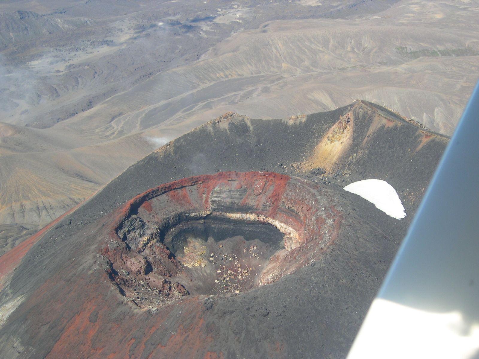
From the Air
Mount Ngauruhoe at 39.16°S, 175.63°E rises to 2,291 m (7,516 ft) with a near-perfect volcanic cone shape instantly recognizable from altitude. Sits between Mount Tongariro to the north and Mount Ruapehu to the south in Tongariro National Park. The Rangipo Desert stretches to the east, and Lake Taupo lies 25 km to the north. Nearest airport is Taupo (NZAP). Active volcanic hazard zone - check NOTAMs. The cone's symmetrical profile makes it an unmistakable landmark from any approach direction.