Mount Rainier National Park
The mountain appears suddenly. One moment you're driving through Douglas fir forest, the next you round a bend and there it is - a wall of ice and rock rising over 14,000 feet into clouds it creates itself. Mount Rainier doesn't just sit on the landscape; it commands it. From a hundred miles away, 'The Mountain' (as locals simply call it) floats above the Puget Sound lowlands like a vision, its glaciers catching alpenglow long after the valleys below have fallen into shadow. This is the most glaciated peak in the contiguous United States, carrying more ice than all other Cascade volcanoes combined, a sleeping giant that reminds Seattle and Tacoma daily that wilderness still looms at their doorstep.
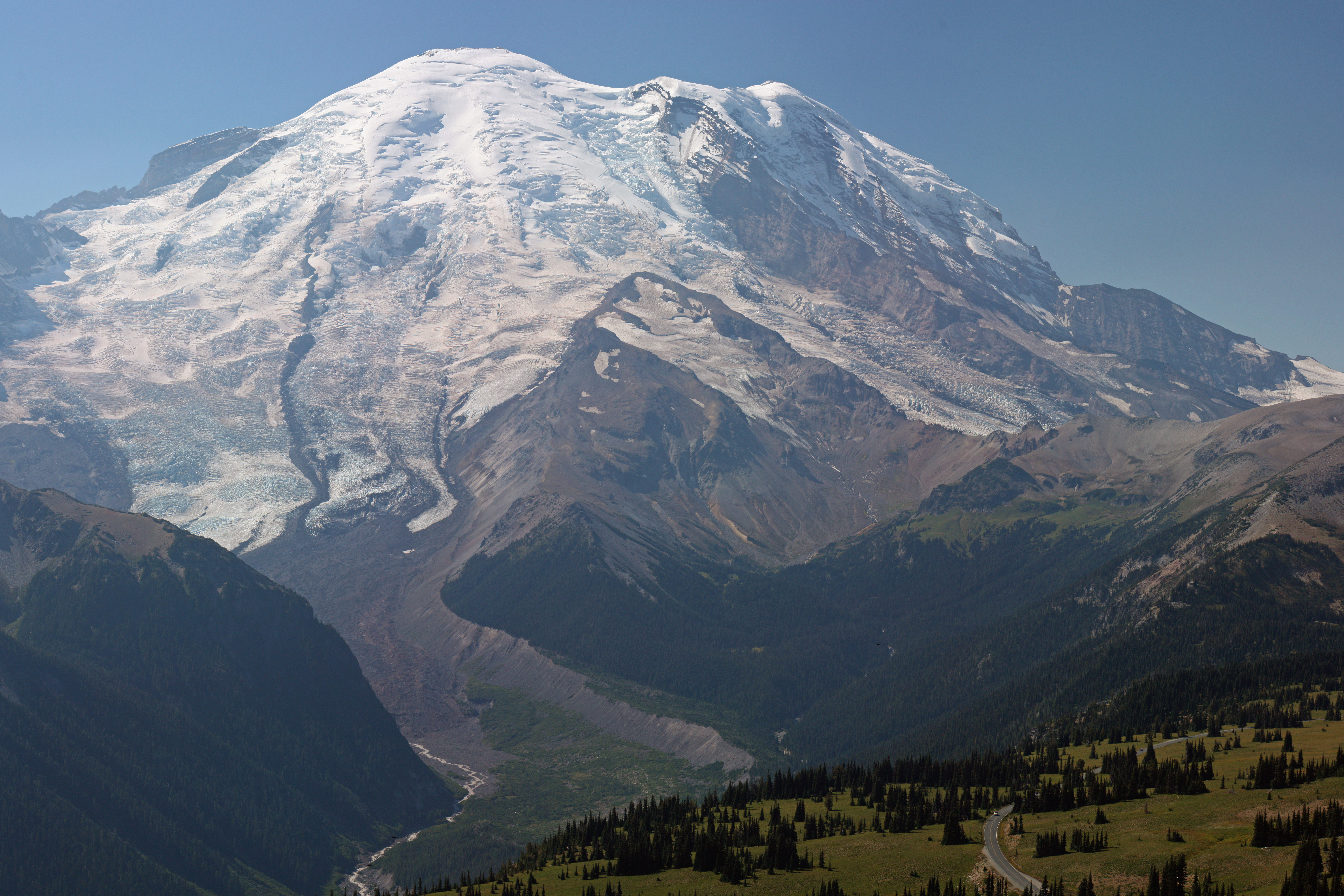
Rivers of Ice
Twenty-six glaciers armor Mount Rainier's flanks, their blue-white tongues descending thousands of feet through frozen waterfalls and crevasse fields. The Emmons Glacier alone covers over four square miles - the largest glacier in the lower 48 states by surface area. Carbon Glacier, on the north side, holds the greatest volume and descends lower than any glacier in the contiguous US outside Alaska.
These rivers of ice are alive with movement. Listen on a warm afternoon and you'll hear groans and cracks as the glaciers shift downslope at rates measured in feet per day. Meltwater pours from ice caves at their snouts, milky with rock flour ground fine by the glacier's passage. The streams run gray-green, carrying the mountain's substance down to valleys where it builds river bars and fertilizes the forests. In a warming world, these glaciers are retreating, but they remain immense - visible from commercial aircraft, unmistakable from the ground, a reminder of ice ages past and perhaps future.
Fire Below
Mount Rainier is a volcano, and not a dormant one. Steam vents melt ice caves near the summit crater, creating the world's largest volcanic cave system - warm labyrinths hidden beneath the ice cap where climbers have sheltered from storms. The last significant eruption occurred about 1,000 years ago, sending mudflows down valleys now occupied by suburbs and shopping malls.
The Osceola Mudflow, 5,600 years ago, was catastrophic - a cubic mile of saturated debris that roared sixty miles to Puget Sound at highway speeds. Today, communities from Puyallup to Auburn sit on its deposits. Lahar warning systems are in place, sirens installed, evacuation routes marked. The mountain's beauty carries risk. But the same volcanic forces that created the hazard also created the grandeur: the steep symmetrical cone, the mineral-rich soils that support wildflower meadows, the hot springs that warm tired hikers after long ascents.
Paradise Found
At 5,400 feet on Rainier's south slope, Paradise earned its name. Henry Longmire's daughter-in-law reportedly exclaimed upon arriving in 1885, 'What a paradise!' The name stuck. In July and August, the subalpine meadows here explode with wildflowers - avalanche lilies, lupine, paintbrush, and pasqueflower creating carpets of color beneath the glacier's edge.
Paradise once held the world record for the most snowfall measured in a single year: 93.5 feet during the winter of 1971-72, before Mount Baker claimed the title with 95 feet in 1998-99. By May, the snowpack can still be thirty feet deep. Yet by August, the meadows are ablaze with color, fed by that same snowmelt. The transition is almost violent - frozen wasteland to alpine garden in weeks. Trails radiate from the historic Paradise Inn, built in 1916, its enormous stone fireplaces still warming hikers who arrive rain-soaked or sunburned depending on the mountain's mood.
The Summit
Reaching Rainier's summit is no casual endeavor. The standard routes require two days, crampons, ice axes, and roped glacier travel. Crevasses hidden by snow bridges have claimed climbers. Altitude sickness strikes above 10,000 feet. Weather can change in minutes from calm to whiteout. Yet roughly 10,000 people attempt the summit each year, with about half reaching the 14,410-foot top.
Those who stand on Columbia Crest look down on everything. The Olympic Mountains rise to the west beyond Puget Sound. Mount Baker floats to the north, Mount Adams and Mount Hood to the south. On exceptional days, you can see the Pacific Ocean. The crater rim holds two small summits and a steaming vent system. Some climbers descend immediately; others linger, knowing they've reached the highest point for a thousand miles in any direction, a place where the ordinary world shrinks to insignificance below.
The Living Mountain
Below the ice, the mountain teems with life. Old-growth forests of Douglas fir, western red cedar, and Sitka spruce cloak the lower slopes, some trees over a thousand years old. Elk herds browse meadow edges at dawn. Black bears gorge on huckleberries in late summer. Mountain goats traverse impossibly steep rock faces, their white coats visible against dark basalt.
The Nisqually River, born at the snout of its namesake glacier, drops through successive life zones: glacier to moraine to subalpine meadow to ancient forest to salmon-bearing waters in the lowlands. That single watershed contains the full spectrum of Cascadian life, from ice worms that live only in glacial ice to salmon that swim up from Puget Sound to spawn. The mountain is an island of wilderness, surrounded by the most densely populated region in the Pacific Northwest, a reminder that wild places can endure even within sight of cities.
From the Air
Located at 46.85°N, 121.76°W. Unmistakable from any approach - the massive glaciated cone rises 14,410 feet, towering over surrounding peaks by thousands of feet. The 26 glaciers are clearly visible, appearing blue-white against dark volcanic rock. The mountain creates its own weather - lenticular clouds often cap the summit. Visible from 100+ miles in clear conditions. The volcanic crater at the summit is distinct. Paradise visitor area visible on south slope at 5,400 ft. Nearby airports: Seattle-Tacoma International (KSEA) 55 nm north, Tacoma Narrows (KTIW) 45 nm northwest. Warning: The mountain generates severe turbulence and icing in poor weather. Clouds can develop rapidly. Best viewing in morning before cumulus builds. Summer offers best conditions; winter storms can obscure the peak for days.