Mount Richard-Molard: The Peak That Changed Its Name for a Dead Geographer
The mountain had a name before the Frenchman arrived. The local communities called it Nouon, and it stood as the highest ground for hundreds of kilometers in any direction, a 1,752-meter peak where the borders of Guinea, Ivory Coast, and Liberia converge. Then Jacques Richard-Molard, a French geographer who had already made his mark by discovering the Richat Structure -- that uncanny geological bullseye in the Mauritanian desert now known as the Eye of Africa -- came to study the Nimba Range. He died in an accident here on July 29, 1951, at the age of 38. The colonial authorities renamed the peak in his honor. Mount Nouon became Mount Richard-Molard, and a mountain that had belonged to the landscape became a monument to a man who briefly passed through it.
The Geographer's Legacy
Jacques Richard-Molard was born in Tunis on April 20, 1913, and spent his career studying the geography and peoples of French West Africa. His most famous discovery came in 1948, when he identified the Richat Structure -- a 40-kilometer-wide series of concentric geological rings in the Saharan desert of Mauritania that he called the "Richat boutonniere." Visible from space, the formation became one of the continent's most recognizable geological features. Richard-Molard's work on the Nimba Range was part of broader research into the Guinea Highlands, a region whose geography remained poorly documented in Western science despite millennia of habitation by local peoples. His death at 38 cut short a career that was reshaping European understanding of West African landscapes. Whether renaming an ancient mountain after a visiting scientist was an appropriate tribute remains a question the name itself cannot answer.
Where Three Countries Meet
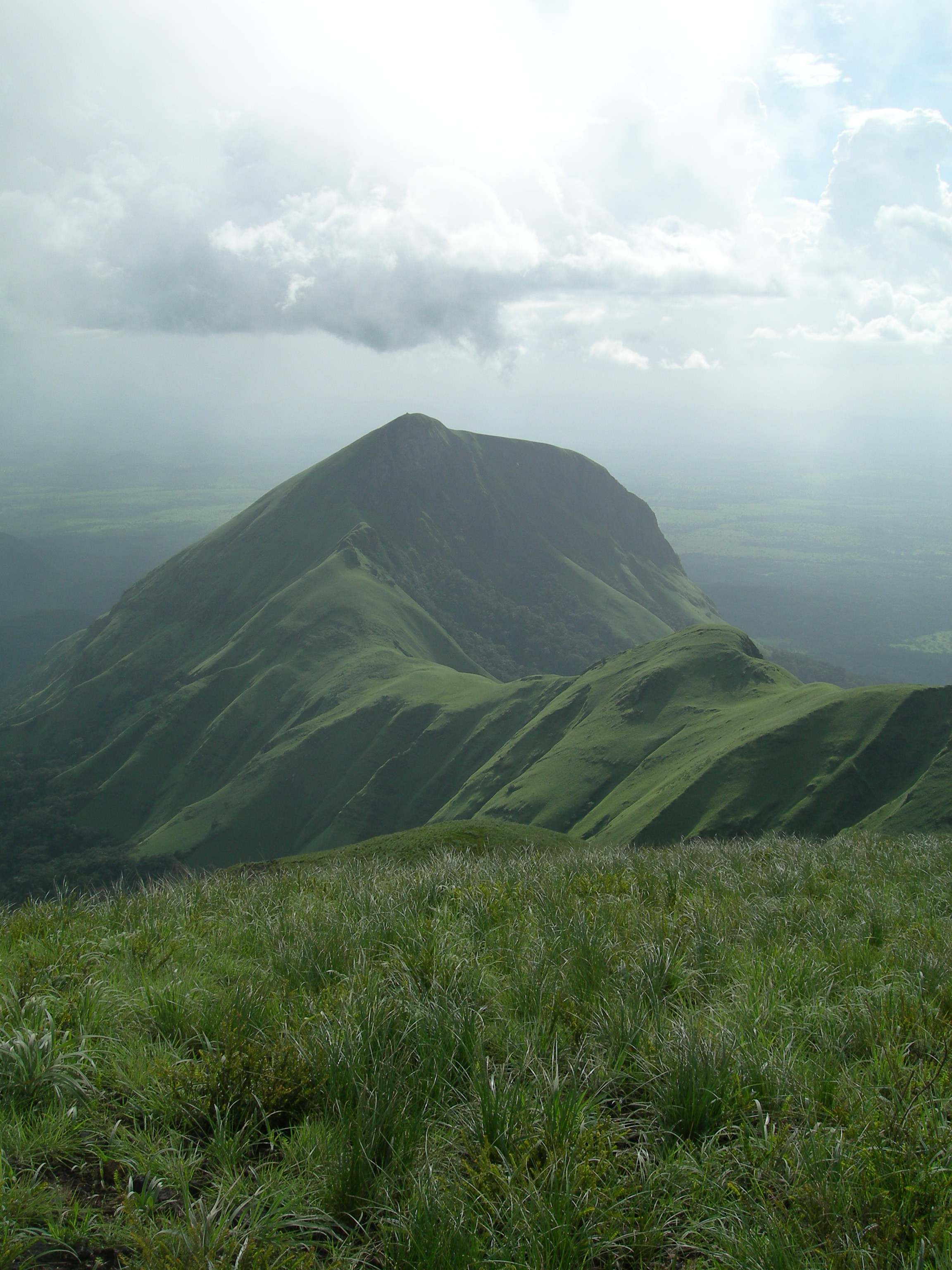
The summit of Mount Richard-Molard sits precisely on the border between Guinea and Ivory Coast, with Liberia's territory beginning just down the southeastern slopes. This tri-national geography is not merely cartographic trivia -- it has shaped the mountain's fate. The Guinean and Ivorian portions fall within the Mount Nimba Strict Nature Reserve, a UNESCO World Heritage Site established in the 1940s that protects the extraordinary biodiversity of the Nimba Range. The Liberian portion received no such protection and was heavily mined for iron ore. At 1,752 meters, the peak is the highest point in both Guinea and Ivory Coast, a distinction that draws the occasional mountaineer willing to reach this remote corner of West Africa. The nearest settlement of any size is Yekepa in Liberia, a mining town at the mountain's base, while the Guinean villages of Bossou and N'Zoo lie to the north.
Iron and Cloud Forest
The Nimba Range is rich in two things that rarely coexist peacefully: iron ore and biodiversity. The mountains' geological foundation includes significant deposits of high-grade iron ore and cobalt, resources that attracted industrial mining on the Liberian side and continue to tempt extraction companies on the Guinean slopes. Meanwhile, the upper elevations support cloud forests and montane grasslands that shelter species found nowhere else on Earth. The tension between mineral wealth and biological wealth defines the mountain's modern history. UNESCO placed the World Heritage Site on its "in Danger" list in 1992, acknowledging that mining pressure -- both active and proposed -- threatens the ecological integrity of the reserve. The mountain that bears a geographer's name has become a case study in the geography of competing interests: what lies beneath the soil versus what lives above it.
A Mountain in the Guinea Highlands
Mount Richard-Molard is the third-highest peak in the Guinea Highlands, behind Mount Bintumani in Sierra Leone at 1,945 meters and Sankan Biriwa also in Sierra Leone at 1,850 meters. The highlands stretch from central Guinea through northern Sierra Leone and Liberia to western Ivory Coast, forming a densely forested plateau that serves as the hydrological backbone of West Africa. Rivers born on these slopes include the Niger, the Senegal, and the Gambia -- waterways that sustained empires and still sustain millions. The Nimba Range, where Richard-Molard stands, is one of the highland's most dramatic features: a narrow ridge rising abruptly from surrounding lowlands, its isolation creating the conditions for extraordinary species endemism. From the summit, on the rare clear day, the forest canopy extends to the horizon in every direction -- an unbroken green that conceals one of the most biologically dense landscapes on the continent.
From the Air
Located at 7.62N, 8.41W on the Guinea-Ivory Coast border with Liberia nearby to the southeast. The peak at 1,752 meters (5,748 feet) is the highest point on the Nimba Range, visible as an elevated ridgeline running northeast-southwest. The mountain is identifiable by the contrast between its green montane slopes and the lower-elevation savanna. The mining scars on the Liberian side are visible from altitude. Nearest airport is Nzerekore (GUNZ), approximately 100 km northwest. The mining town of Yekepa sits at the eastern base. Cloud cover is frequent above 900 meters, especially during the wet season from May to October. Maintain altitude well above the ridgeline and expect turbulence along the range.