Mount St. Helens
The north side is simply gone. Where a symmetrical peak once rose to 9,677 feet, there's now a horseshoe-shaped crater blown open to the north, its interior walls a mile across and two thousand feet deep. On May 18, 1980, Mount St. Helens erupted with the force of 27,000 Hiroshima bombs, leveling 230 square miles of forest in minutes, dropping the summit by over 1,300 feet, and killing 57 people. It remains the deadliest and most economically destructive volcanic event in American history. But what draws visitors today isn't just the destruction - it's the resurrection. Four decades on, the blast zone has become an extraordinary open-air laboratory where nature rebuilds itself, one pioneering plant and returning elk at a time.
The Day the Mountain Fell
The eruption began not at the summit but at the side. Weeks of earthquakes had destabilized the north flank, which bulged outward at an alarming rate. At 8:32 AM, a magnitude 5.1 earthquake triggered the largest landslide ever recorded - the entire north face slid away, releasing the pressurized magma within. The lateral blast exploded northward at 300 miles per hour, temperatures reaching 600 degrees.
Thirty miles of the Toutle River valley vanished under debris. Old-growth forest snapped like matchsticks. Spirit Lake, beloved by generations of campers, was raised 200 feet by avalanche debris and filled with a logjam of floating timber that still chokes its waters. Harry Truman, the 83-year-old lodge owner who refused to evacuate, lies buried somewhere beneath 150 feet of volcanic rubble. The mountain had last erupted in 1857. It waited 123 years to remind everyone what it was capable of.
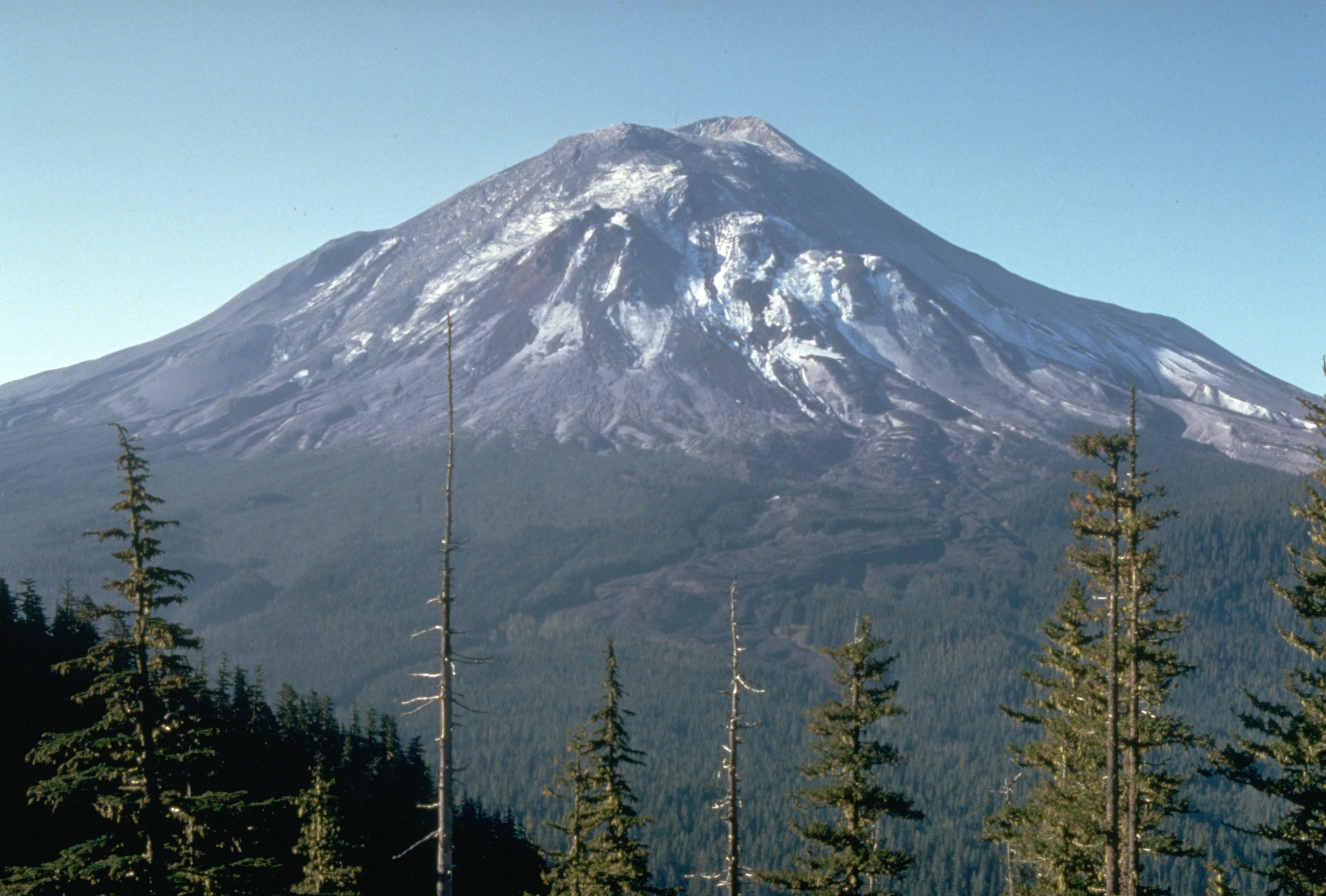
The Gray Zone
In the immediate aftermath, the blast zone looked like the surface of the moon. Pumice and ash covered everything in monochrome gray. Trees lay in perfect alignment, pointing away from the crater like fallen soldiers. Biologists predicted recovery would take centuries, if it happened at all.
They were wrong. Pocket gophers emerged from underground burrows, churning the ash and buried soil together. Elk hooves broke the ash crust, allowing seeds to take root. Fireweed appeared within months - its name earned from colonizing burned areas. Lupine fixed nitrogen in the sterile soil. Within a decade, scattered trees had survived in protected pockets. Today, young forests fill the outer blast zone while the inner sanctum remains raw and recovering. The National Volcanic Monument protects this process, allowing nature to proceed without human interference - a rare opportunity to witness ecological succession from scratch.
Inside the Crater
Since 1980, a new lava dome has grown inside the crater - Crater Glacier now wraps around it, the only glacier in North America advancing rather than retreating, fed by the crater walls' shade and avalanches. The dome rises over 1,100 feet, a plug of cooled lava that continues to grow imperceptibly. Seismographs record the mountain's heartbeat, detecting the magma stirring below.
The volcano erupted again from 2004 to 2008, adding more material to the dome but without explosive violence. Steam vents still puff from the crater. Rock occasionally calves off the dome's unstable flanks. This is not a dead volcano but a sleeping one, catching its breath between outbursts. Scientists monitor it constantly, their instruments detecting tremors too subtle for human perception, watching for signs of the next awakening.
The View from Johnston Ridge
Five miles from the crater, the Johnston Ridge Observatory offers an unobstructed view into the amphitheater. Named for David Johnston, the USGS volcanologist who radioed 'Vancouver! Vancouver! This is it!' moments before the blast killed him at this very location, the observatory stands as both memorial and scientific outpost.
The panorama is humbling. The breach gapes wide, its walls layered with the volcanic history of eruptions past. The lava dome smokes gently. Spirit Lake gleams gray-green behind its timber mat. And everywhere, the land bears witness: standing dead timber in the 'tree blowdown zone,' stumps shorn off at snow level, pumice plains slowly greening. On clear days, you can see Mount Rainier to the north and Mount Hood to the south - the Cascade chain of volcanoes marching toward both horizons, each one capable of its own fury.
Climbing the Mountain
Permits are required to climb Mount St. Helens above 4,800 feet, and they sell out quickly. The standard route ascends the south side - the one untouched by the blast - through alpine meadows and snowfields to the crater rim at 8,365 feet. From there, climbers peer into the amphitheater, across the lava dome, and out through the breach where the north face once stood.
The descent is legendary: thousands of feet of volcanic ash and pumice that climbers glissade in minutes, sinking to their knees, sliding and stumbling in a controlled fall. Sand shoes help. So does a healthy tolerance for grit. By the time you reach the car, volcanic ash will have infiltrated every piece of clothing you own. But you'll have stood on the rim of America's most famous volcano, looked into the crater that changed our understanding of volcanic hazards, and descended a mountain that reminds us, more than any other, that the Earth is still very much alive.
From the Air
Located at 46.19°N, 122.18°W. Instantly recognizable by the massive horseshoe-shaped crater opening to the north - the 1980 blast zone is still visible as a gray swath of devastated terrain spreading northward. The mountain rises to 8,365 feet (lost 1,314 feet in the eruption). The lava dome inside the crater is visible from above. Spirit Lake appears gray-green to the north with its distinctive log mat. The contrast between the forested south slopes and barren north crater is stark. Johnston Ridge Observatory visible on a ridge 5 miles north of crater. Nearby airports: Kelso-Longview (KKLS) 35nm west, Portland International (KPDX) 50nm south. Caution: Volcanic terrain generates turbulence. The crater can produce strong downdrafts. Restricted airspace may apply during volcanic activity.