Mount Vottovaara
The name gives it away, if you know where to listen. In the Sami language, votto derives from a word meaning to conquer, to overcome, to win. Vaara means mountain. Vottovaara is the Mountain of Victory, and no other region in northern Russia or Scandinavia clusters so many features bearing that same root: the Votto River, Lake Vottoozero, Lake Vottomuks, Lake Keivotto. Something happened here that the Sami considered worth naming five times over. Standing at 417.3 meters above sea level in the central Republic of Karelia, Vottovaara is the highest point of the West Karelian Upland, and its plateau holds a collection of boulders that have inspired decades of debate about where nature ends and human intention begins.
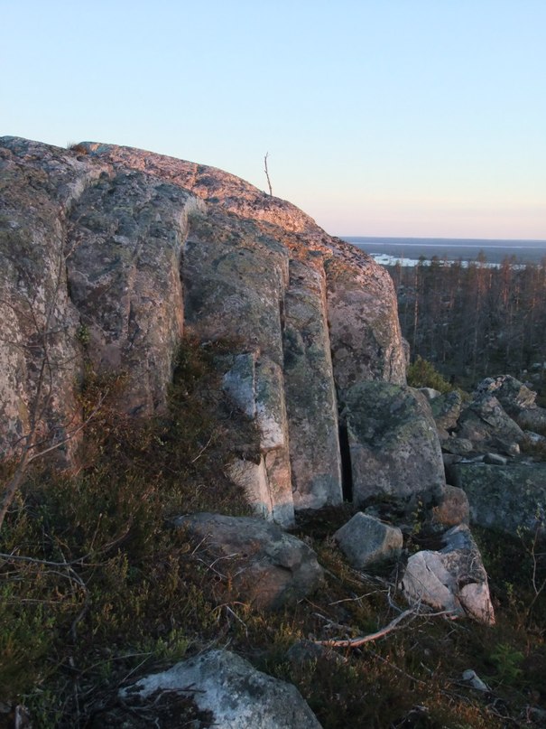
Stones That Ask Questions
The plateau is scattered with rounded boulders, some enormous, some balanced on smaller stones in arrangements that look deliberate. In the late 1970s, Sergei Simonyan, a local historian from the nearby Sukkozero settlement, was the first to report these formations as man-made structures. Archaeologists M.M. Shakhnovich and I.S. Manyukhin studied the mountain in the early 1990s and concluded that the stones had a cultic purpose connected to Sami culture. Their publications drew attention far beyond the archaeological community, attracting followers of mystical and pseudoscientific movements who projected their own theories onto the mountain's strange landscape. The debate over the stones continues. Some scientists at the Karelian Scientific Center of the Russian Academy of Sciences believe many are naturally formed clusters, with others being modern constructions left by visitors.
Deep Time on the Karelian Craton
Vottovaara's geology tells a story measured in billions, not thousands, of years. The mountain sits in the western wing of the Yangozero synclinorium, the second largest geological structure on the Karelian Craton, one of the oldest stable segments of Earth's continental crust. The ridge stretches approximately seven kilometers in a north-south direction, composed of Jotnian quartzites and quartzite-sandstones fractured by numerous geological faults. Some of these fractures may have been rejuvenated during the post-glacial period, when the retreat of ice sheets released pressures that had been building for millennia. The mountain covers six square kilometers, and its plateau bears the scars of ice ages that ground and shaped the rock into the forms that now puzzle visitors.
Where Hunters Climbed to Pray
Archaeological landmarks in central Karelia date back five to six thousand years, and the Sami presence in this landscape is intimately tied to the seasons. Vottovaara is surrounded by lakes stocked with fish and lies at the intersection of seasonal migration routes for reindeer. These routes are remarkably stable across centuries; reindeer follow the same paths their ancestors walked, and the humans who depended on them learned to predict those movements with precision. Before the hunting and fishing seasons began, Sami hunters and fishermen would climb the mountain to offer gifts to the sieidi -- sacred stones believed to channel spiritual power. Whether the balanced boulders on the plateau are those same sieidi or merely natural formations that inspired the practice is a question the mountain does not answer directly.
Protection and Pilgrimage
In August 2011, the Government of the Republic of Karelia declared the Vottovaara mountain complex a natural monument, placing more than 1,500 hectares under protection. The designation covers the mountain itself and its surrounding territory, acknowledging both its geological significance and its cultural resonance. The protection was overdue. As Vottovaara's reputation grew through publications in the 1990s and 2000s, increasing numbers of visitors arrived, some drawn by archaeology, others by the mountain's reputation as a place of spiritual power. The modern constructions that some scientists note among the stones -- cairns and arrangements left by visitors as memorials of their pilgrimage -- add a new layer to a landscape already thick with meaning.
A Name Spoken Five Times
Researchers Vladimir Charnoluski and Georgy Kert, specialists in Sami customs and toponymic vocabulary, noted something remarkable about the clustering of the Votto name around this mountain. Five geographic features in close proximity share the root, a concentration unmatched anywhere else in northern Russia or Scandinavia. The name may relate to ancient cultic sites, or it may have epic origins lost to time. What survives is the landscape itself: the quartzite ridge rising above the taiga, the lakes that sustained generations of hunters and fishermen, and the boulders that sit on the plateau in their ambiguous arrangements, neither clearly natural nor convincingly artificial. Vottovaara remains a mountain that invites interpretation but resists certainty, which may be the most honest thing a sacred place can do.
From the Air
Located at 63.07N, 32.62E in the Muezersky District of the Republic of Karelia, Russia. The mountain rises to 417 meters above sea level, the highest point of the West Karelian Upland. Visible as a distinctive ridge surrounded by lakes and boreal forest. Recommended viewing at 2,000-4,000 feet. The nearest settlement is Sukkozero, approximately 20 km to the northwest. No nearby airports; Petrozavodsk (ULPB) is the nearest significant airfield, roughly 200 km to the southeast. The plateau and its boulder fields are identifiable from lower altitudes.