Mount Waialeale
Its name means "rippling water" in Hawaiian, and the understatement is almost comic. Mount Waialeale, the 5,148-foot shield volcano near the center of Kauai, has averaged more than 373 inches of rain per year since 1912. In 1982, it recorded 683 inches -- nearly 57 feet of rainfall in a single year. Rain falls here on somewhere between 335 and 360 days annually, depending on which source you consult, and the distinction hardly matters. The summit is perpetually drenched, wrapped in clouds, and streaked with waterfalls that cascade down sheer green walls the locals call the "Wall of Tears."
The Rain Machine
Waialeale is not merely wet by coincidence. Its extraordinary rainfall results from a precise collision of geography and atmosphere. The mountain's northern position among the Hawaiian Islands exposes it to more frontal weather systems during winter than its southern neighbors. Its summit sits just below 6,000 feet, the trade wind inversion layer above which clouds cannot rise, meaning moisture-laden air is trapped and compressed against the peak. On three sides, valleys more than 3,000 feet deep funnel available moisture directly toward the summit like a catchment basin. The steep cliffs generate intense orographic lift, forcing air to rise over 4,000 feet in less than half a mile and wringing nearly all the water from incoming clouds. The result is rainfall distributed remarkably evenly throughout the year, with no true dry season. Various sources have measured the annual total differently -- 11,455 millimeters, 11,680 millimeters, even claims of 13,000 millimeters -- but all agree on the essential point: this is one of the most reliably soaked places on the planet.
The Alakai Wilderness
All that water has to go somewhere, and on Waialeale it creates the Alakai Wilderness Preserve, a vast boggy expanse unlike anything else in Hawaii. The ground is so saturated that hiking trails exist more in theory than in practice. Access by foot to the Waialeale area is extremely difficult; the terrain is less a forest floor than a sponge. Yet this hostile, waterlogged landscape harbors some of the rarest plants in the world. Several species bear the mountain's name: Astelia waialealae, Melicope waialealae, and the endemic Dubautia waialealae, plants that evolved here and exist nowhere else. In 2010, the U.S. Fish and Wildlife Service designated critical habitat on Kauai for 48 endangered species, many of them dependent on the unique conditions Waialeale creates. The mountain functions as a biological ark, its very inhospitability serving as protection against the invasive species that have devastated lowland Hawaiian ecosystems.
Contested Crown
Kauai's tourist industry has long promoted Waialeale as the wettest spot on Earth, and for decades the claim held. But recent measurements have complicated the picture. Big Bog on the island of Maui, over the period from 1978 to 2007, averaged 404 inches of rain per year, surpassing Waialeale's long-term average. Cherrapunji and Mawsynram in northeastern India have also been cited as contenders. The competition, such as it is, reflects how difficult it is to measure rainfall consistently in remote mountain environments where gauges overflow, access is limited, and measurement periods vary. What remains beyond dispute is that Waialeale's summit occupies rare atmospheric territory. The combination of trade winds, topography, and latitude that produces its rainfall is specific enough that moving just a few miles in any direction dramatically reduces the totals. The leeward coast of Kauai, barely 15 miles away, receives only about 20 inches of rain per year.
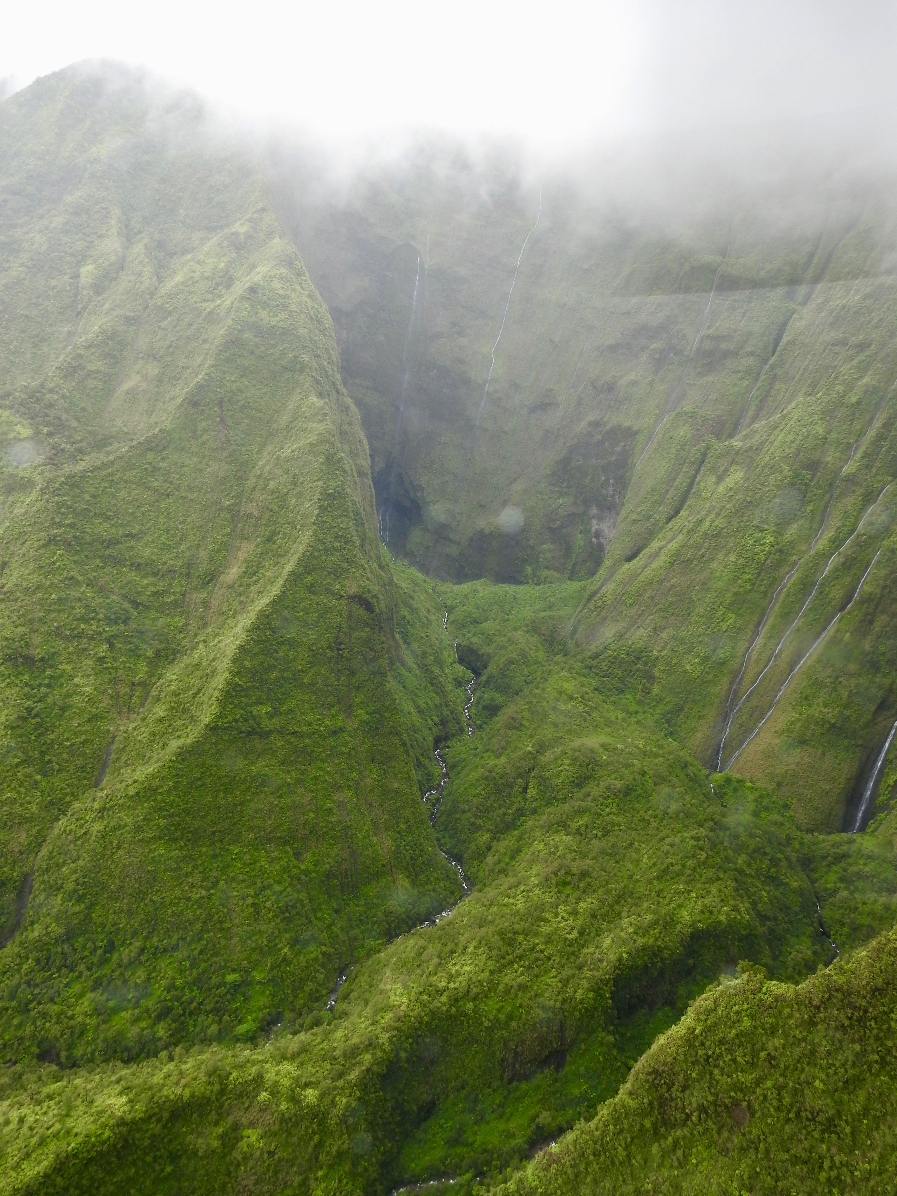
A View Rarely Seen
Most visitors to Kauai never see Waialeale clearly. The summit is cloud-covered so often that catching a glimpse of the caldera and its cascading waterfalls is considered a lucky break. From the Pihea Trail in Kokee State Park, a sign proclaims the view ahead as one of the wettest spots on Earth, though the view itself is frequently obscured by the very weather that earned the distinction. Helicopter tours offer the most reliable perspective, circling close enough to the Wall of Tears to see dozens of waterfalls streaming down the near-vertical green walls of the ancient caldera. The sight is dramatic and fleeting. Clouds can close in within minutes, and pilots must navigate rapidly changing conditions. For those who see it, the mountain delivers on its name. Water does not merely fall here. It ripples across every surface, streams down every cliff face, and saturates the air itself until the boundary between rain and atmosphere dissolves entirely.
From the Air
Located at 22.07°N, 159.50°W near the center of Kauai, summit at 5,148 feet MSL. Exercise extreme caution: the summit is cloud-covered most of the time with very limited visibility. Mountain obscuration and turbulence are frequent. Maintain safe terrain clearance -- minimum 6,500 feet MSL recommended for overflight. Nearby airport: Lihue Airport (PHLI), approximately 12 nm southeast. The Wall of Tears waterfalls on the east face are the primary visual feature when visible. Expect rain at any time of year.