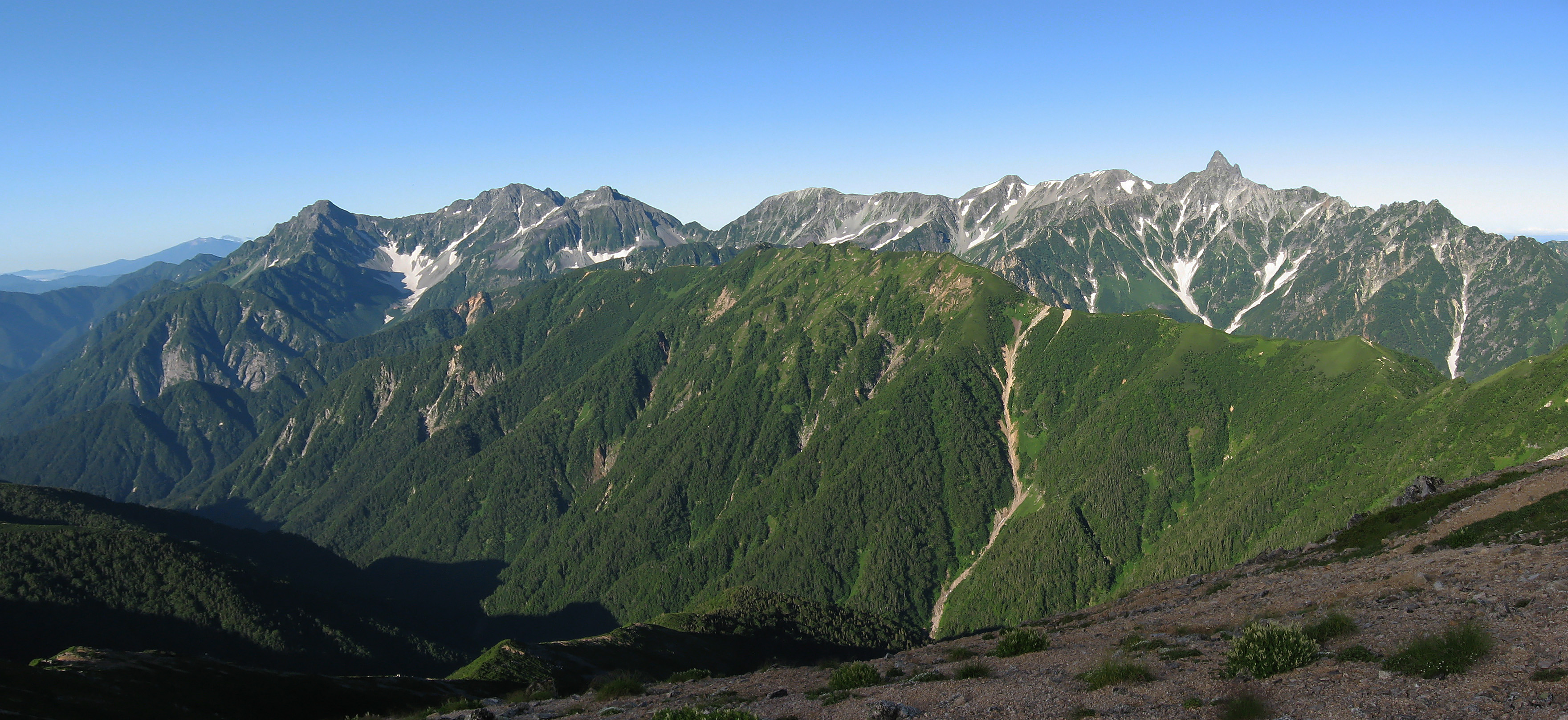
Mount Yari
The Japanese call it Yari-ga-take, the Spear Peak, and from a distance the name needs no explanation. A single granite pyramid punches through the ridgeline of the Hida Mountains at 3,180 meters, so sharply pointed that early European visitors compared it to the Matterhorn. Four ridges radiate from the summit like the arms of a compass -- Higashikama to the east, Yarihotaka to the south, Nishikama to the west, Kitakama to the north -- each one a knife-edge walk between deep valleys. It is the fifth-highest mountain in Japan, and among serious climbers, it may be the most coveted.
The Priest Who Opened the Way
The first recorded ascent belongs to Banryu, a Buddhist priest who reached the summit on July 28, 1828. For half a century after Banryu's climb, the peak remained the province of religious pilgrims and local hunters. Then came the foreigners. In 1878, English geologist William Gowland became the first non-Japanese person to stand on the summit -- the same Gowland who would coin the phrase "Japanese Alps" to describe the Hida Mountains. Thirteen years later, in August 1891, Reverend Walter Weston made his own ascent, adding Mount Yari to the growing list of peaks he was introducing to a global mountaineering audience. In 1922, Maki Yuko completed the first winter ascent, a feat that pushed the mountain into a different category of difficulty entirely.
Four Ridges, Four Dangers
Each of Mount Yari's ridges offers a distinct character and a distinct level of peril. The Higashikama ridge, part of the Omoteginza route, is the classic approach from the east, beginning at Nakabusa Onsen and traversing Tsubakuro-dake and Otensho-dake before the final push to the summit. The Nishikama ridge follows the Uraginza route from the west, linking a chain of peaks including Washiba-dake and Sugoroku-dake. But it is the Kitakama ridge to the north that commands the most fearsome reputation. On December 20, 1959, a climbing party from Senshu University was ascending the Kitakama when an avalanche struck, killing nine. The ridge became the subject of Jiro Nitta's novel and its subsequent manga adaptation, cementing its place in Japanese mountaineering lore as a route where ambition and danger walk side by side.
The Spear in Summer
During climbing season, Mount Yari transforms from a remote alpine fortress into one of Japan's busiest high-altitude destinations. Climbers queue for popular routes, particularly the Yarisawa approach from Kamikochi, which follows the Azusa River through forest and alpine meadow before the steep final ascent. The Yarihotaka traverse -- linking Mount Yari to the Hotaka peaks via the notorious Daikiretto gap -- is considered one of the great ridge walks in the Japanese Alps, a multi-day expedition that demands scrambling skill and a head for exposure. A network of mountain huts makes these ambitious routes surprisingly feasible: Yari-ga-take Sanso perches just below the summit, while Sessho Hut, Hut Oyari, and Yarisawa Lodge provide shelter at lower elevations. In 2005, a new trail was constructed from Hidarimata Valley to Mount Okumaru, opening yet another approach from Shinhodaka Onsen.
A Summit of Contradictions
Two triangulation points sit at the top of Mount Yari, along with a milepost stone fixed into the rock. Yet for all its fame, the Geographical Survey Institute of Japan considers the summit unremarkable as a reference point -- on official topographic maps, it appears as nothing more than an elevation marker. The Azusa River begins here, flowing south through Kamikochi to eventually join the Shinano River, Japan's longest waterway. A temple founded by Banryu once stood in this vicinity, connecting the peak to its spiritual origins. Today the summit is crowned by a small metal shrine and the ladders that help climbers negotiate the final exposed scramble to the very top. On clear days, the view extends across the entire Hida range: Sugoroku-dake, Nishi-dake, Minami-dake, and beyond them, the distant cone of Mount Fuji.
From the Air
Mount Yari (Yari-ga-take) is at 36.342N, 137.647E, elevation 3,180 meters (10,433 ft), the fifth-highest peak in Japan. Its distinctive spear-shaped summit is unmistakable from the air -- a sharp pyramid with four pronounced ridges radiating in each cardinal direction, separated by deep valleys. Located within Chubu-Sangaku National Park in the Hida Mountains. The nearest airport is Matsumoto Airport (RJAF), approximately 55 km east. Surrounding terrain is extremely rugged with multiple peaks exceeding 3,000 m. Mountain weather is highly variable with rapid cloud formation. The Kamikochi valley is visible to the south-southwest as a distinctive flat corridor at 1,500 m elevation.