Mukurob
The Nama people had a saying about the rock. As long as it stands, they told each other, the power of the white man endures. On the night of 7 December 1988, the Mukurob -- a 12-meter-tall, 450-ton sandstone pillar that had balanced on a base just 3 meters long and 1.5 meters wide -- collapsed in the darkness near Asab, in what was then South West Africa. A farmer and his three sons discovered the fallen rock the next morning. A few weeks later, South Africa, Angola, and Cuba signed the Tripartite Agreement at United Nations headquarters in New York, setting in motion the process that would lead to Namibian independence on 21 March 1990.
Fifty Thousand Years of Erosion
Mukurob was once part of the Weissrand Plateau, a sandstone escarpment in the southern Namib Desert. Over roughly 50,000 years, wind and water eroded the surrounding rock until the formation stood alone -- a top-heavy column whose widest point measured 4.5 meters across, perched on a pedestal far narrower than the mass it supported. The physics of it seemed improbable. Geologists studied the structure repeatedly, trying to understand how sandstone could sustain such an imbalance for so long. The formation drew visitors from around the world, becoming one of Namibia's most famous natural landmarks. The Afrikaans name for it was Vingerklip -- Finger Rock. English speakers called it the Finger of God.
The Nama and the Herero
The rock had been known to the Nama people for generations and carried stories older than any colonial presence. One legend, told in many versions, explained both the name and the significance. The Herero people, the story went, once traveled south from their grazing lands in central Namibia to taunt the Nama. "Look how rich we are, with our nice fat cattle," they boasted. "What have you got? Nothing but rocks!" The Nama replied that they had one very special rock, and that they were lords of the country as long as it stood. The Herero, annoyed, tied thongs into a long rope, wound it around the pillar, and hitched their cattle to pull it down. They failed. "There you see!" the Nama shouted -- in their language, the words that gave the rock its name.
National Monument, National Symbol
Before its collapse, Mukurob was one of Namibia's greatest tourist attractions. The South African administration granted it National Monument status on 1 June 1955, classified under geology. Visitors arrived from across the world to stand beneath the improbable column and photograph the desert light catching its sandstone surfaces. Several geological studies examined the formation's structure and stability. For the Nama, the rock carried a deeper weight than tourism or geology could account for. Their oral tradition held that the fall of Mukurob would signal the end of colonial power in their land -- a prophecy that lived alongside the scientific measurements and the tourist brochures, patient and unfalsifiable until the night it came true.
The Night It Fell
What caused the collapse remains uncertain. A rainstorm had passed through the area the week before, and some researchers believe that water seeping into the sandstone weakened the already stressed base. Another study pointed to a more distant cause: the 1988 Spitak earthquake in Armenia, a magnitude 6.8 event that killed roughly 25,000 people, registered seismic activity in Namibia on the same night that Mukurob fell. Whether it was rain, seismic waves traveling thousands of kilometers through the Earth's crust, or simply the final moment in 50,000 years of accumulated erosion, the pillar gave way sometime during the night of 7 December 1988. No one witnessed it. The farmer who found the rubble the next morning saw only the aftermath -- a heap of sandstone blocks where a landmark had stood for longer than human memory.
After the Fall
The timing was extraordinary. Within weeks of the collapse, the geopolitical architecture of southern Africa shifted. On 22 December 1988, South Africa, Angola, and Cuba signed agreements at the United Nations that finalized terms reached earlier in Geneva. Angola and Cuba signed a separate bilateral agreement on Cuban troop withdrawal, clearing the path for Security Council Resolution 435 to take effect on 1 April 1989. Namibia became independent on 21 March 1990. The Mukurob's National Monument status was never revoked. The site near Asab still holds the broken remnants of the formation, scattered across the desert floor where the pillar once stood. Whether one reads the coincidence as prophecy fulfilled or geological timing, the story of Mukurob remains inseparable from the story of Namibian independence -- a 450-ton sandstone column that held out for 50,000 years and fell at precisely the right moment.
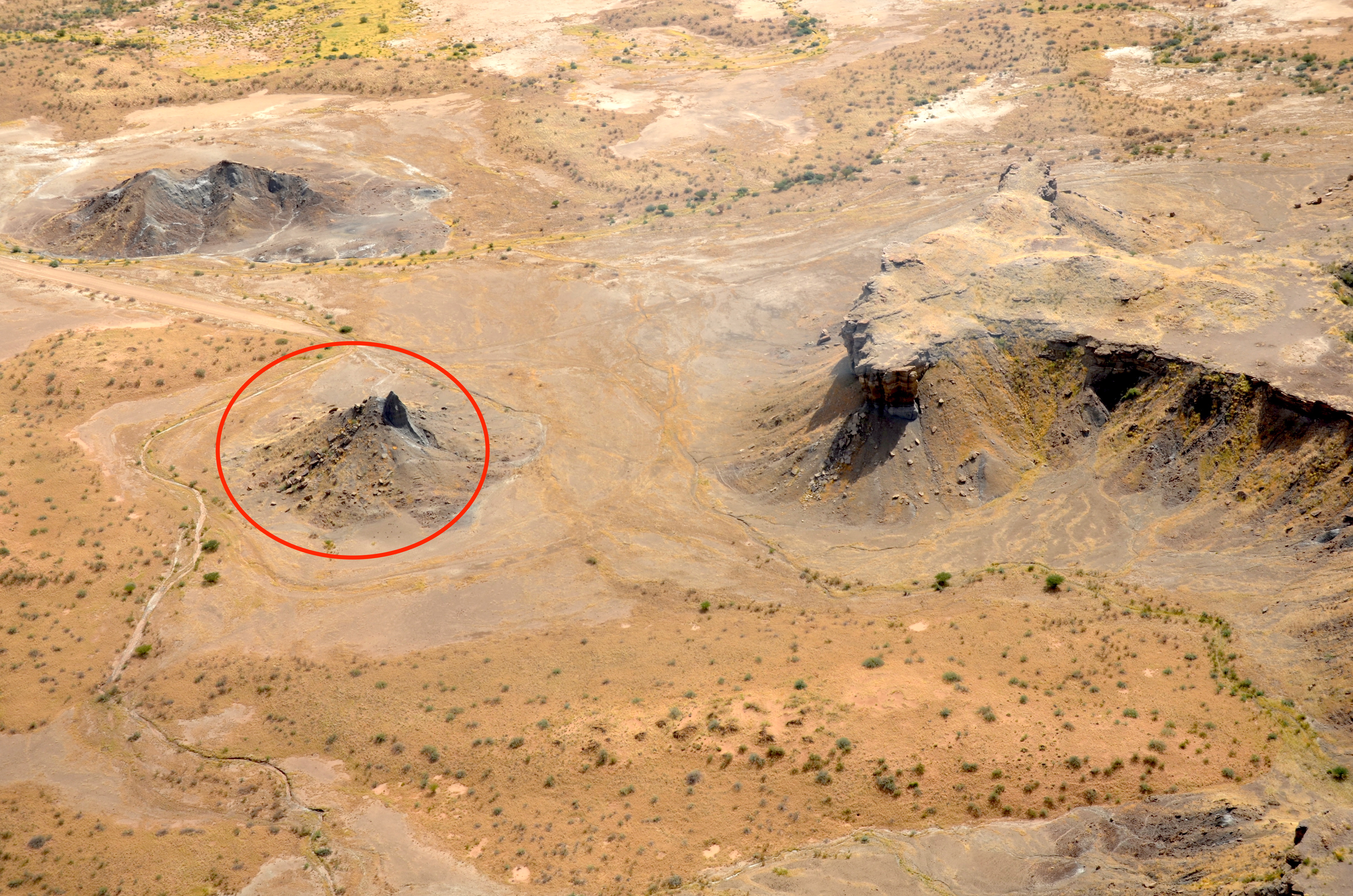
From the Air
The Mukurob site is located at 25.50S, 18.17E near Asab in the Karas Region of southern Namibia. The Weissrand Plateau is visible as a distinct escarpment from altitude. At 3,000-6,000 feet AGL, the flat desert terrain and plateau edge are clearly distinguishable. The nearest airport is Keetmanshoop Airport (FYKT), approximately 80 km to the south. The area is arid with generally excellent visibility. The collapsed rock formation itself is not visible from high altitude, but the plateau geography that created it is a recognizable feature.