Muttrah
The souq earned its name from the darkness. In the maze of stalls and alleyways between Al Lawatiya Mosque and Khour Bimba, the lanes are so narrow and the shops so crowded that sunlight cannot reach the ground. Shoppers once needed lamps to find their way at midday. Muttrah -- Oman's most densely populated district and the commercial heart of the capital before oil changed everything -- still operates by this principle: pack the goods tight, stack the alleys deep, and let the smells of frankincense, jasmine, and perfume oil guide you through.
The Dark Market
Souq Muttrah stretches along the harbor in two sections locals call the small market and the large market. The main thoroughfare carries household goods, shoes, and ready-made garments. Turn off this central corridor, though, and the souq reveals its older character. Side streets offer Omani silver jewelry, white dishdashas with embroidered kumahs, brightly colored cloth, and multicolored head scarves. Framed khanjars -- the curved daggers that are Oman's national symbol -- hang in tiny shops alongside hookah pipes, incense holders, and, for those who know where to look, old Arabian muskets. During Eid seasons, Omanis travel from across the country to buy garments and jewelry here, and the already dense market becomes almost impassable.
The Walled Neighborhood
Within Muttrah lies Sour Al-Lawatiah, a small community enclosed by an old wall that speaks to one of Oman's least-known demographic stories. The al-Lawatiyah tribe settled here in waves of immigration from Sindh, in present-day Pakistan, between 1780 and 1880. They brought with them the Luwati language, an Indo-Aryan tongue first documented by the Omani historian Ibn Ruzayq. The tribe insularized themselves inside the walled neighborhood, preserving their language and customs in the midst of Arab Muscat. Sour Al-Lawatiah remains a distinctive enclave today, its very existence a reminder that Oman's position on the Indian Ocean trade routes made it a place where South Asian, Persian, East African, and Arab cultures have mingled for centuries.
Port of Every Empire
Before Muscat had oil, it had Muttrah's harbor. The port sits in a natural anchorage 250 kilometers south of the Strait of Hormuz, positioned to serve the Persian Gulf, the Indian subcontinent, and East African markets simultaneously. When diplomat Edmund Roberts visited in the early 1830s, the district held about 8,000 people. During the 18th-century reign of Sayyid Sultan bin Ahmed, Muttrah was designated the commercial port while Muscat proper handled naval operations. After Sayyid Said's death in 1856, maritime commerce declined and ships had to anchor offshore while cargo was unloaded manually into small boats. Sultan Qaboos transformed the harbor in 1974, establishing Mina Qaboos -- now Port Sultan Qaboos -- and modernizing facilities that made containerized shipping possible by the mid-1980s.
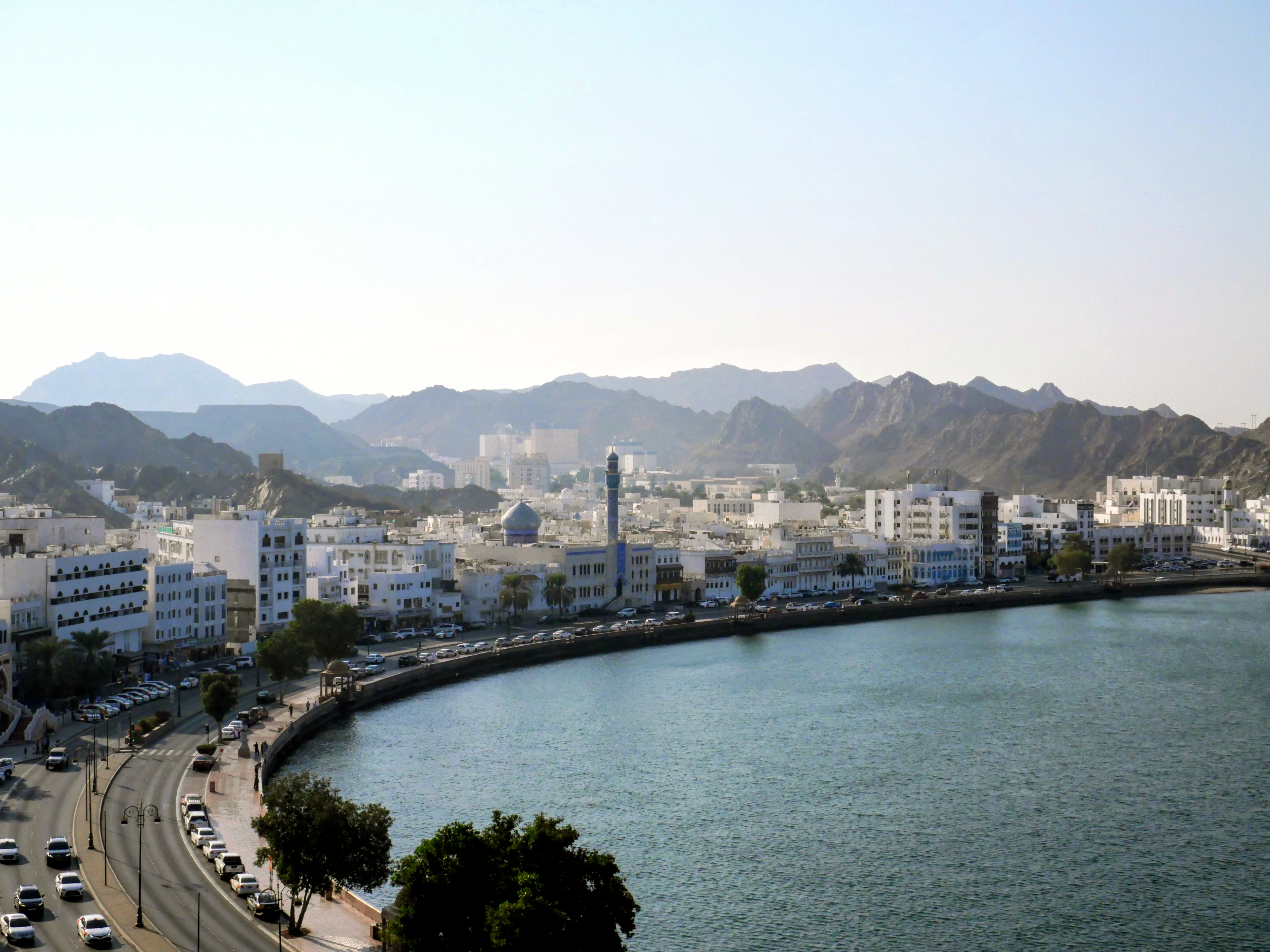
Blood at the Corniche
Muttrah's history is not only commercial. In January 1871, the district witnessed the death of Imam Azzan bin Qais, who had ruled Oman since deposing his cousin Salim bin Thuwaini in 1868 and declaring a short-lived Ibadi imamate. Azzan lost to Sayyid Turki bin Said at the Battle of Dhank in October 1870, then was killed fighting at Muttrah. The transition ended one of Oman's periodic experiments with theocratic governance and restored the sultanate model that continues today. Today, Muttrah's corniche -- a waterfront promenade flanked by watchtowers and traditional architecture -- gives no sign of the battle. The district population has grown to over 234,000, making it the most densely packed province in the nation.
From the Air
Muttrah is at approximately 23.62N, 58.57E, directly west of Old Muscat along the coast. Port Sultan Qaboos is clearly visible from altitude as a major harbor facility. The Muttrah Corniche waterfront road and surrounding traditional architecture are visible at lower altitudes. The souq is inland from the harbor, within the dense urban fabric. Nearest airport: Muscat International (OOMS).