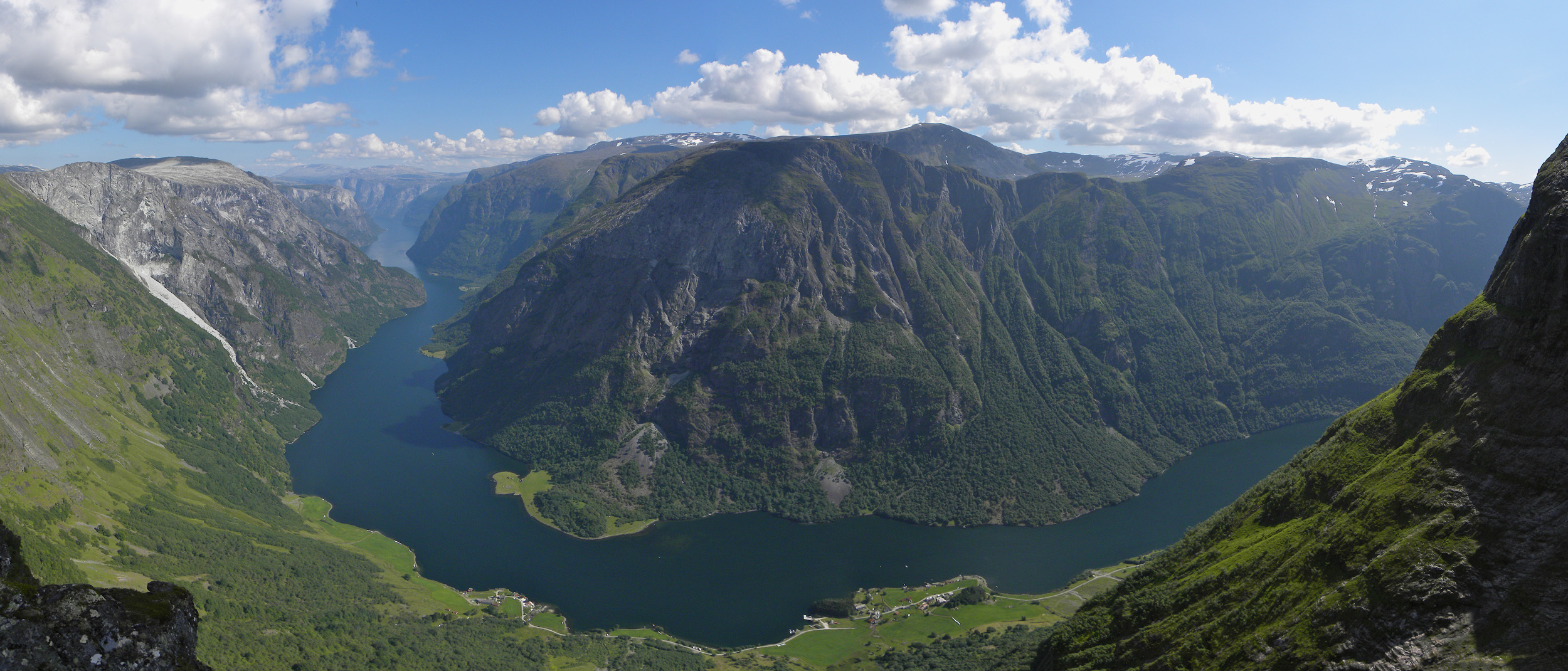
Naeroyfjord
At its narrowest point, the Naeroyfjord squeezes to just 250 meters across. The rock walls on either side rise nearly vertically, climbing to 1,400 meters above the waterline while the fjord floor plunges to depths of 500 meters below it. That means the total vertical scale of the landscape, from submerged bedrock to the summit ridges, approaches two kilometers. Stand on the deck of a ferry passing through this corridor and the dimensions feel impossible, as if someone had taken a mountain range and sliced it open with a knife. The Naeroyfjord is an 18-kilometer branch of the Sognefjord, Norway's longest and deepest fjord, and since 2005 it has held UNESCO World Heritage status alongside the Geirangerfjord. The National Geographic Society has rated the pair the world's top natural heritage site.
How Glaciers Built a Masterpiece
The Naeroyfjord's shape is a textbook of glacial geology. During the last Ice Age, rivers of ice carved their way toward the sea, transforming V-shaped river valleys into the U-shaped troughs that define Norway's western coast. The glaciers scoured the crystalline rock walls into near-vertical cliffs, polishing surfaces that still gleam where waterfalls have not yet stained them green with moss. The fjord's narrowness is not accidental; it reflects a zone where the bedrock was harder, resisting the glacier's widening but not its deepening. The result is a channel that feels more like a canyon than a body of water, with depths reaching 500 meters in places and shallowing to just 12 meters at its shallowest. The river Naeroydalsevi flows down through the Naerodalen valley and enters the fjord at Gudvangen, a village at the fjord's innermost end where the cliffs crowd so close that direct sunlight reaches the valley floor for only part of the year.
Villages at the Water's Edge
Human settlement along the Naeroyfjord has always been constrained by the terrain. There is simply nowhere flat to build. The village of Bakka clings to the western shore, its white-painted Bakka Church one of the few structures visible from the water. Gudvangen sits at the fjord's head, accessible by the European route E16 highway, which arrives through a tunnel after threading its way through the surrounding mountains. The farms along the fjord's steep sides were historically reached only by boat, and some of the old farmsteads perched on narrow shelves of land above the waterline have been abandoned for generations. In June 2006, Queen Sonja of Norway unveiled a plaque at Bakka commemorating the World Heritage designation, a moment that formalized what centuries of isolation had preserved. The fjord's remoteness was its protection; there was never enough flat ground to support the kind of development that might have diminished its landscape.
The Sognefjord's Innermost Secret
To understand the Naeroyfjord, you need to understand its parent. The Sognefjord stretches 205 kilometers inland from the coast and plunges 1,308 meters below sea level, making it Norway's longest and deepest fjord and the second-longest in the world after Scoresby Sund in Greenland. The Naeroyfjord branches off its southern shore, one of at least a dozen major arms that reach into the surrounding mountains like the fingers of a hand. Where the Sognefjord is wide enough to feel oceanic in places, the Naeroyfjord is intimate and claustrophobic, a place where echoes carry from wall to wall and waterfalls cascade directly into the water from hanging valleys hundreds of meters above. Sightseeing boats navigate the fjord daily during summer, threading between the cliffs at slow speed while passengers crane their necks upward. The experience is less sightseeing than immersion, a passage through geology made visceral.
Living Heritage in a Changing Climate
The UNESCO designation recognizes the Naeroyfjord not just for its beauty but for what it represents: an outstanding example of how glaciation shaped the earth's surface. The inscription covers both the Naeroyfjord and Geirangerfjord as examples of fjord landscapes that are among the most scenically outstanding anywhere on the planet. But the glaciers that created these landscapes are themselves in retreat. The Jostedalsbreen ice cap, whose meltwater feeds many of the streams cascading into the Sognefjord system, has been shrinking measurably in recent decades. The fjord itself is unchanging on a human timescale, its rock walls indifferent to the centuries, but the frozen forces that carved it are diminishing. For now, the Naeroyfjord remains exactly what the glaciers left behind: a narrow corridor of water and stone that compresses the scale of a continent into a space you can almost reach across.
From the Air
Located at 60.94N, 6.93E in Aurland Municipality, Vestland county. The fjord is a narrow branch off the southern shore of the Sognefjord, identifiable from the air as a thin dark line cutting between steep mountain walls. Gudvangen village sits at the inner end. The E16 highway and tunnels are visible nearby. Nearest airports: Bergen/Flesland (ENBR) approximately 150 km southwest, Sogndal/Haukasen (ENSG) approximately 45 km northeast. Best viewed at 1,500-3,000 meters to appreciate the fjord's narrowness relative to the surrounding peaks. Cloud cover frequently fills the valleys.