Na Pali Coast State Park
The name says it plainly: na pali means "many cliffs." But no translation prepares you for what the northwest coast of Kauai actually looks like. Vertical walls of green velvet, pleated by millennia of rainfall, drop four thousand feet into surf so blue it seems artificially saturated. Waterfalls appear and vanish with the clouds, threading down ridgelines that have no roads, no power lines, no cellphone towers. The 6,175-acre state park that protects this stretch of coast exists precisely because humans never figured out how to tame it.
Carved by Catastrophe
Five million years ago, a massive deluge spilled across the northwest flank of Kauai and began carving the valleys that define this coast today. The island is the second-oldest in the inhabited Hawaiian chain, and time has done extraordinary work here. Erosion has sculpted the basalt into cathedral-like spires and knife-edged ridges that catch the trade winds and wring moisture from the clouds. The result is one of the wettest places on Earth, where rainfall feeds hanging valleys and sends waterfalls cascading into narrow gorges that open, suddenly, onto hidden beaches of gold and red sand. The Kalalau Valley, the largest of these amphitheater valleys, was considered significant enough to warrant the park's creation in the first place.
The People of the Valleys
Polynesian navigators reached the Na Pali Coast around 1200 AD, and Tahitian migrants followed soon after, shaping the culture that would define Kauai for centuries. The coast became a center of trade linking Hanalei, Waimea, and the neighboring island of Niihau. Terraced taro fields climbed the valley walls, and stone-walled house platforms lined the streambeds. It was a self-sufficient world, connected to the rest of Hawaii but protected by the very cliffs that made arrival so difficult. After Captain Cook visited Kauai in 1778, Western contact brought diseases that devastated the coastal communities. The Hawaiian population along the Na Pali Coast dwindled steadily, and the last known native residents were recorded in the early twentieth century. The valleys they cultivated have been slowly reclaimed by jungle, though remnants of their agricultural terraces remain visible to hikers who know where to look.
Eleven Miles on the Edge
The Kalalau Trail is the only land route into this coast, and it earns every superlative thrown at it. Starting from the end of Hawaii Route 560, the trail traverses eleven miles and crosses five major valleys before arriving at Kalalau Beach. Side trails branch upward toward waterfalls hidden in the valleys above. The path narrows to a ledge in places, with nothing between your boots and the ocean but several hundred feet of crumbling red earth. Beyond Kalalau Beach, the coast all the way to Polihale Beach is unreachable on foot, accessible only by kayak, boat, or helicopter. Camping requires a permit, and stays are limited to five nights on the Kalalau Trail, with a single night maximum at the Hanakoa camp. A third campsite at Milolii can only be reached from the water. These restrictions exist for good reason: the terrain is unforgiving, and the coast has claimed unprepared hikers who underestimated its difficulty.
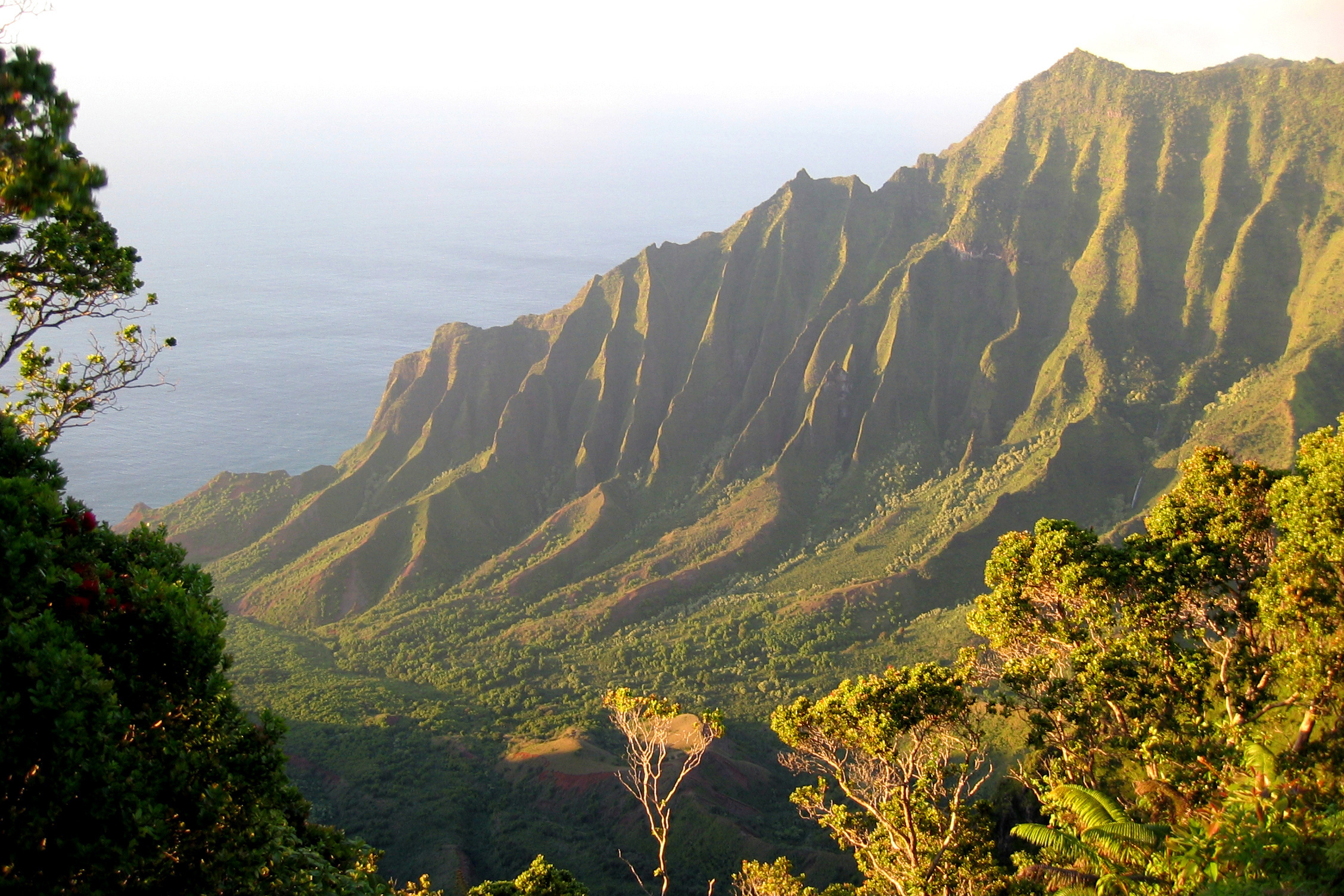
A Wilderness Viewed from Every Angle
What makes the Na Pali Coast unusual among wilderness areas is how many ways it can be experienced without setting foot on it. Charter boats depart from Port Allen and Hanalei Bay, running along the base of the cliffs where sea caves open into turquoise grottos. Kayakers paddle the same route in summer, threading through arches worn into the rock by centuries of wave action. Helicopter tours offer the aerial perspective that has made this coastline one of the most photographed landscapes in Hawaii. From above, the corrugated ridgelines look like the folds of a green curtain draped across the island's edge, and the scale becomes apparent in a way that ground-level views cannot convey. The adjacent Hono O Na Pali State Natural Reserve, established in 1983 and expanded to over 3,578 acres in 2009, extends the protected area into the sharp ridges accessible from Kokee Road in Waimea Canyon.
From the Air
Located at 22.18N, 159.64W on the northwest coast of Kauai. The dramatic fluted cliffs are best viewed from 1,500-3,000 feet AGL approaching from the ocean side. Lihue Airport (PHLI) is the nearest major field, approximately 15 nautical miles southeast. The coast runs roughly 16 miles from Kee Beach to Polihale. Expect orographic clouds along the ridgeline, especially in afternoon hours. The green pleated cliffs are unmistakable from any altitude.