Naarden
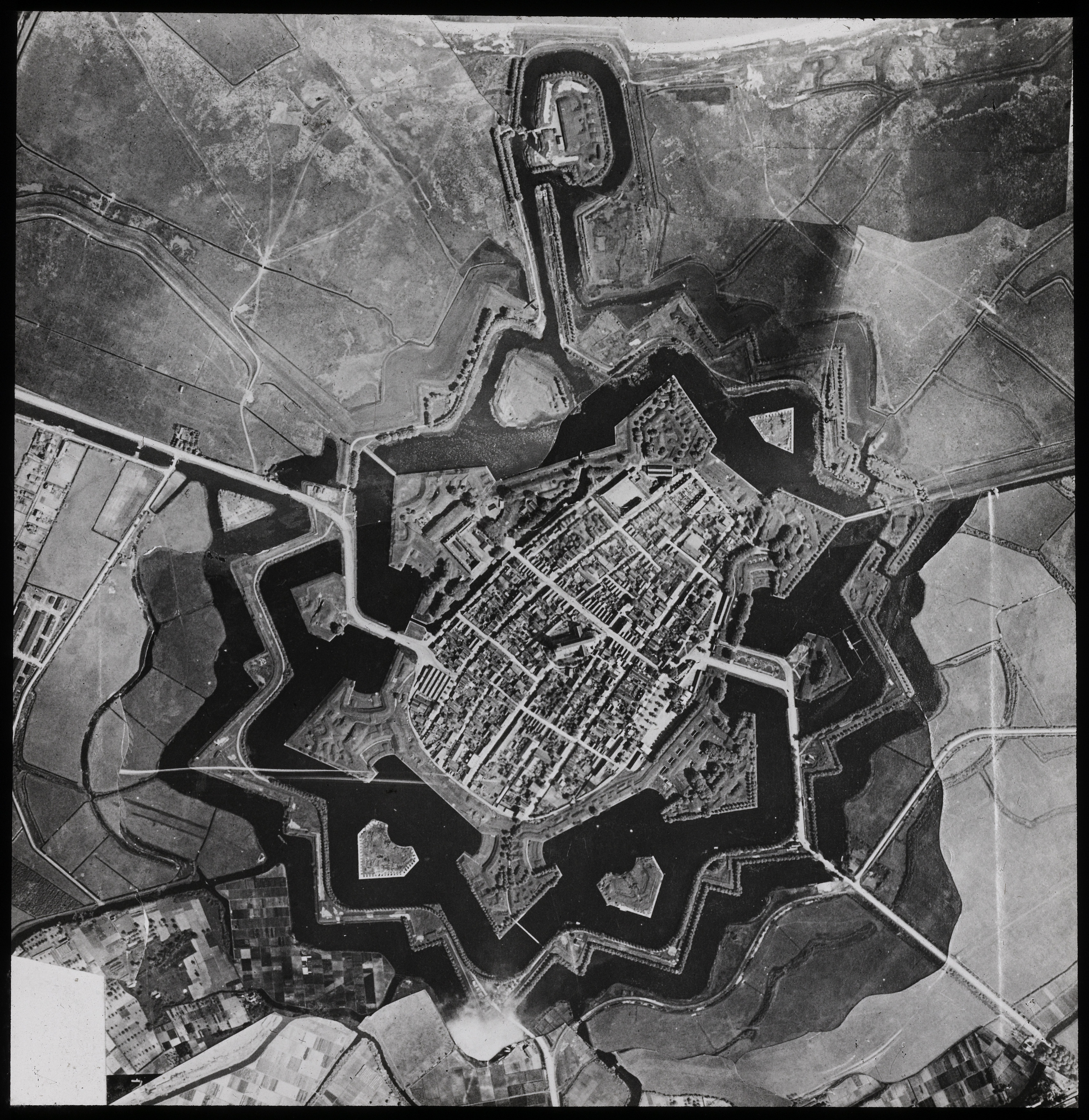
From the air, Naarden is a geometry problem. Twelve sharp points, two concentric moats, ramparts shaped like the corners of an enormous green snowflake - a town drawn with a compass and a straightedge by engineers who had decided, after one terrible afternoon in November 1572, that this would never happen again. The town is roughly the same size now as it was then. Roughly five thousand people live inside the star. And every Good Friday they pack the Great Church to hear Bach's *St. Matthew Passion*, an annual rite older than most of the houses.
The Day in November
Naarden had been granted city rights in 1300 - the only town in the Gooi region to hold them. It was prosperous, fortified, textile-rich, and in the autumn of 1572 it was caught between Catholic Spain and the rebellious Protestant provinces of what would become the Dutch Republic. On 1 December that year, Spanish soldiers under Don Frederic of Toledo entered the town. They told the residents to gather in the Spaanse Huis - a converted church on what is now Turfpoortstraat - to hear a peace proposal. When the citizens had assembled, the soldiers opened fire. Roughly 700 townspeople died in what historians call the Massacre of Naarden, part of the wider Spanish Fury campaign. Only about 60 inhabitants survived. The soldiers then set the town on fire. A plaque above the lintel of the Spaanse Huis still names what happened there. The Dutch rebels, by all contemporary accounts, did not forget. The destruction of Naarden hardened their war, and they kept fighting Spain for another seventy-six years.
The Star Takes Shape
What rose from the ashes was a different kind of town. Over the next two centuries Dutch military engineers reshaped Naarden into one of the purest surviving examples of the bastioned star fort - six (later twelve) pointed bastions arranged around the city core, two moats nested one inside the other, and earthen ramparts wide enough to mount cannon. The geometry was not decoration. The angles were calculated to eliminate dead ground - any approaching attacker would be raked by overlapping fields of fire. The walls were rebuilt again during the French era between 1795 and 1814, when Napoleon's engineers found them useful for their own purposes. After the Battle of Leipzig in 1813, an allied force of Dutch, Prussian, and Russian troops liberated the Netherlands - but Naarden's French commander refused to believe Napoleon had really fallen, and held out under siege for months. In May 1814 the French finally marched out, granted the honors of war. The walls held.
Comenius
John Amos Comenius, born in Moravia in 1592, spent his last years as a Czech exile in Amsterdam. He is one of those figures whose ideas are so thoroughly absorbed into everyday life that nobody thinks of them as ideas anymore. He argued that children should be taught in graded levels by age. He argued that girls should be educated as well as boys. He argued that schools should use pictures, not just words. The system of grades and classes that nearly every modern school still runs on traces back, more or less directly, to his writing. When he died in 1670, the small Walloon community in Amsterdam buried him in Naarden. His mausoleum is on Kloosterstraat, and Czechs still come from Prague to leave flowers. The Comenius Museum, which moved from the old Spaanse Huis to its current location after 1992, tells the rest of the story.
Bach on Good Friday
The Great Church - Grote Kerk, formerly St. Vitus - dates from the fifteenth century, which means it predates the 1572 massacre and somehow survived it. The painted wooden vaults inside, with scenes from the Old and New Testaments, were plastered over during the Reformation and rediscovered centuries later under the whitewash. Every Good Friday since 1922, the Nederlandse Bachvereniging has performed Bach's *St. Matthew Passion* in this church - a tradition now older than a century. Tickets sell out months in advance. The acoustics of a medieval Dutch hall church and an audience of Dutch listeners who have heard this music every spring of their lives make it one of the strangest, most moving concerts in Europe.
Beacon for Bombers
The same geometry that made Naarden hard to attack in the seventeenth century made it impossible to mistake from the air in the twentieth. During the Second World War, Allied bomber crews returning from raids deep in Germany used the unmistakable star shape as a navigation fix. There is something difficult to summarize in that: a fortress designed to keep one war out had become a landmark guiding the planes home from another. The town was a separate municipality until 2015. On 1 January 2016 it merged with Muiden and Bussum into the new municipality of Gooise Meren. Hilversum surpassed it in size in the eighteenth century and never gave the lead back, but Naarden has the thing Hilversum does not: a shape you can recognize from twenty thousand feet.
From the Air
Located at 52.30 N, 5.16 E, about 20 km southeast of Amsterdam. From altitude Naarden is unmistakable - a twelve-pointed star outlined in dark moats and green ramparts, with the medieval town core packed inside. The distinctive shape made it a wartime navigation aid; pilots today still spot it easily. Nearest airports: Schiphol (EHAM) 35 km west, Lelystad (EHLE) 25 km northeast. Best viewed from low cruising altitudes (3,000-5,000 ft) in oblique morning or evening light, which throws the rampart geometry into relief.