Nairobi
Nairobi began as a railway depot. In 1899, the engineers building the Uganda Railway from Mombasa to Lake Victoria needed a supply station before tackling the Rift Valley escarpment. They chose a swampy plain that the Maasai called Enkare Nairobi - 'place of cool waters' - for its springs and relatively healthy altitude. The depot became a town, the town became the capital of British East Africa in 1907, and the capital became one of Africa's largest cities. The railway that created Nairobi still runs through the city center, now paralleled by a Chinese-built standard gauge line. The swamp has become a national park where lions hunt zebras within view of office towers - the only capital city in the world with such wildness within its limits. Nairobi holds 4.4 million people in a metropolitan area approaching ten million, the commercial hub of East Africa, headquarters of the United Nations Environment Programme, a city that went from nothing to everything in little more than a century.
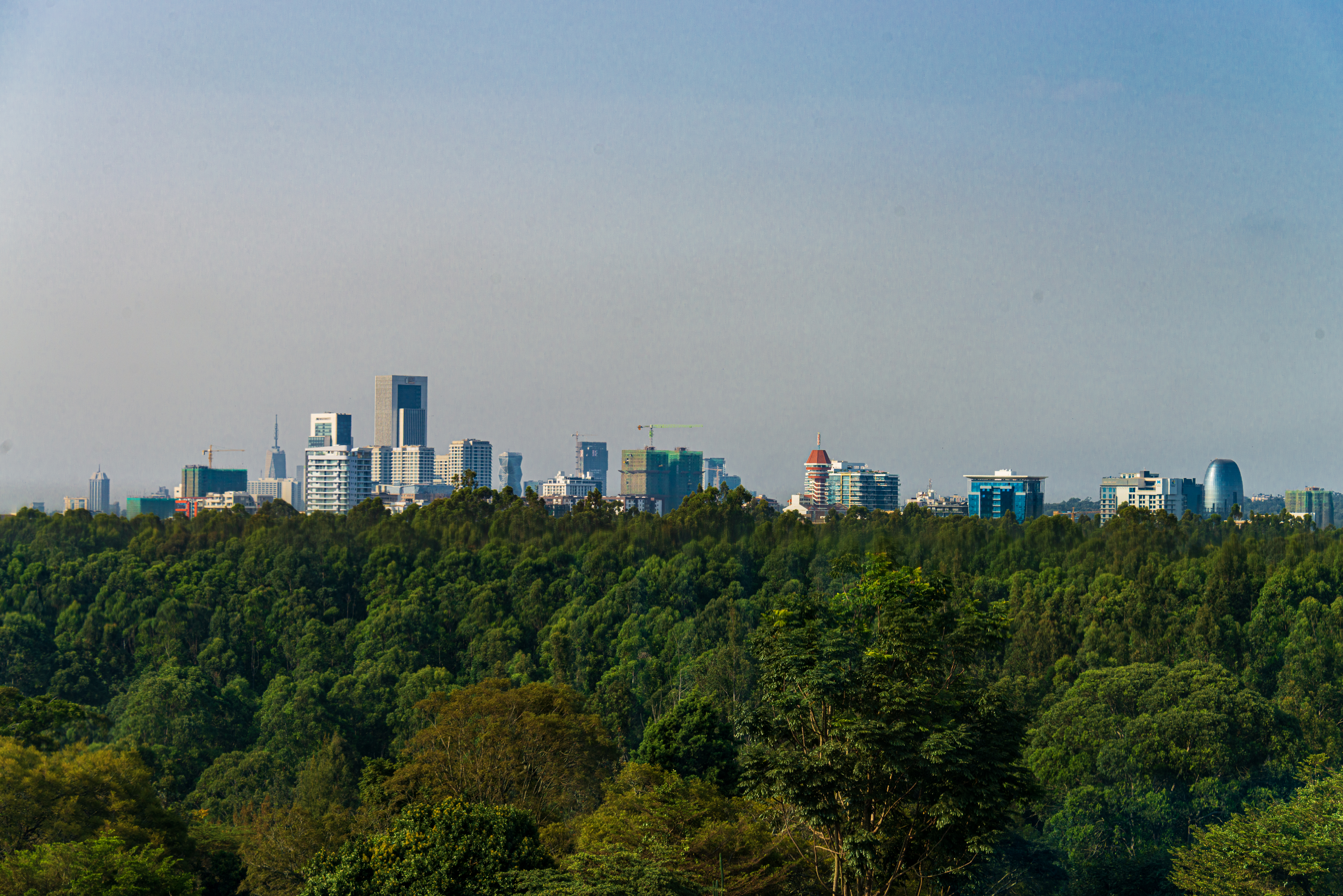
The Railway City
The Uganda Railway was called the 'Lunatic Express' by critics who questioned why Britain would spend £5 million to build a line through territory it barely controlled to a lake that led nowhere profitable. The construction killed hundreds of workers - malaria in the lowlands, accidents in the highlands, lions at Tsavo that dragged men from their tents. The railway was completed in 1901, and the supply depot at mile 326 became a town.
The railway station, completed in 1899 and rebuilt in 1929, still stands in the city center - a colonial building surrounded by matatus (minibuses) and hawkers and the chaos of African urbanization. The Chinese-built Mombasa-Nairobi Standard Gauge Railway, opened in 2017, runs parallel but terminates outside the center, its modern station as different from the colonial original as the China that built it is from the Britain that preceded it. The old line still carries freight; the new line carries passengers at three times the speed. Nairobi sits between them, the city the railways created now served by railways from different centuries and different empires.
The National Park
Nairobi National Park covers 117 square kilometers at the city's southern edge - savanna and riverine forest where buffalo, giraffes, leopards, and lions roam within sight of skyscrapers. The park was established in 1946, one of Kenya's first, when Nairobi was small enough that wilderness seemed distant. Now the city has surrounded three sides of the park; only the southern boundary remains open, a wildlife corridor connecting to the greater Athi-Kapiti plains.
The corridor is controversial. Developers want to build on land that animals need to migrate; conservationists argue that closing the corridor would doom the park's ecosystem. Fences have been proposed, rejected, partially built, debated endlessly. Meanwhile, lions continue to hunt zebras while office workers look down from towers a few kilometers away. The juxtaposition is unique - nowhere else can you photograph rhinos with a city skyline behind them. The question is whether the juxtaposition can survive. Nairobi National Park exists because the colonial government drew lines on a map; keeping those lines meaningful requires decisions the independent government has not yet made.
The Slums and the Skyscrapers
Kibera is one of Africa's largest informal settlements - estimates of its population range from 250,000 to over a million, depending on where boundaries are drawn and how residents are counted. The settlement began in 1912 as a camp for Nubian soldiers who had served the British; it grew as rural Kenyans migrated to the city faster than formal housing could accommodate them. The tin-roofed shacks spread across a valley two kilometers from the central business district, visible from the high-rises that represent Nairobi's other face.
The contrast defines Nairobi more than any architectural landmark. The city that hosts multinational corporations and UN agencies also holds neighborhoods where families share pit latrines and electricity is pirated from overhead lines. The inequality is not hidden - you can see Kibera from the main road to the airport - but neither is it addressed. Successive governments have promised upgrading; some improvements have been made; the fundamental conditions persist. Nairobi works because millions of people have adapted to conditions that formal planning has failed to provide for, building economies and communities in spaces that maps label as informal.
The Hub of East Africa
Nairobi's Jomo Kenyatta International Airport is the busiest in East Africa, connecting the region to the world. The port at Mombasa handles goods destined for Uganda, Rwanda, Burundi, South Sudan - landlocked countries that depend on Kenya's infrastructure. The Nairobi Stock Exchange lists companies from across the region. The city has become what its colonial founders never intended: the commercial center of a bloc of nations that barely existed when the railway depot was built.
The transformation reflects geography and accident. Nairobi's altitude - 1,795 meters - gives it a climate more comfortable than the coast. Its central location made it a natural hub when the East African Community formed, dissolved, and reformed. The presence of international organizations - the UN, NGOs, aid agencies - created an ecosystem of hotels, services, and educated workers that attracted further investment. The cycle has been self-reinforcing: Nairobi grew because it was already big enough to matter. The growth brought problems - traffic, pollution, crime - but the momentum continues. East Africa needs a hub, and Nairobi has claimed the role.
The Matatu City
The matatus - privately owned minibuses - are Nairobi's de facto public transport. The vehicles, typically decorated with elaborate paint schemes, graffiti, and sound systems, fill the gap that formal planning left open. There is no municipal bus network, no metro, no tram; there are only matatus, numbered by route, crammed with passengers, competing for space on roads designed for far fewer vehicles.
The system is chaotic and functional. Matatus leave when full, stop where passengers want, charge what the market will bear during rush hour. The drivers are notorious for recklessness; the touts who hang from the doors shouting destinations are Nairobi's street-level soundtrack. Efforts to regulate the industry have produced mixed results - route designations, painted stripes, banned graffiti - but the matatus persist because nothing else does. The traffic jams that choke Nairobi's roads are matatu jams, the chaos of a city that grew faster than infrastructure, where private enterprise fills the gaps that public planning leaves open.
From the Air
Nairobi (1.29°S, 36.82°E) lies on a plateau at 1,795m elevation in Kenya's Central Highlands. Jomo Kenyatta International Airport (HKJK/NBO) is located 18km southeast of the city center with two runways: 06/24 (4,117m) and 14/32 (4,117m). Wilson Airport (HKNW) within the city handles general aviation and safari flights. The high elevation affects aircraft performance significantly, especially on hot days. Nairobi National Park is visible immediately south of the airport - wildlife is occasionally reported on or near runways. The city center with its high-rises is visible to the northwest. The Ngong Hills (2,460m) rise to the west. The Great Rift Valley escarpment lies 50km west. Weather is tropical highland with two rainy seasons (March-May, October-December). Temperatures are moderate year-round due to altitude. Afternoon thunderstorms are common in rainy seasons. Morning haze and fog can affect operations.