Nakatajima Sand Dunes
Every New Year's morning, crowds gather on this windswept Pacific shore south of Hamamatsu to watch the first sunrise of the year climb above the horizon. The ritual feels ancient, yet the ground beneath their feet is anything but permanent. The Nakatajima Sand Dunes, stretching four kilometers along the Shizuoka coastline and reaching 600 meters inland, rank among Japan's three largest dune systems alongside the famous Tottori Sand Dunes and Kujukuri Beach in Chiba Prefecture. But unlike those better-known siblings, Nakatajima is engaged in a slow-motion disappearing act, its sands retreating at a pace that alarms scientists and locals alike.
Born from Mountains, Shaped by Wind
The story of Nakatajima begins far from the ocean, high in the Akaishi Mountains -- the Southern Japanese Alps. For thousands of years, the Tenryu River carried sediment from those peaks southward through steep valleys, depositing vast quantities of sand where it meets the Pacific near Hamamatsu. Ocean currents then pushed that sand along the coast, while persistent onshore winds sculpted it into the rolling dune formations visible today. The system is a collaboration between mountains, river, sea, and wind -- each element playing its part in a geological relay that has operated for millennia. The dunes shift constantly, their shapes rearranged by gusts that sweep in off the Philippine Sea, creating a landscape that never looks quite the same from one week to the next.
A Coastline in Retreat
The collaboration is breaking down. Beginning in the mid-twentieth century, a series of dams built along the Tenryu River for hydroelectric power and irrigation began trapping the sediment that once flowed freely to the coast. The first dam on the main stream, Yasuoka Dam, was completed in 1935, and construction continued through the decades until the Funagira Dam closed the chapter in 1976. Each dam intercepted more of the river's sandy payload. Meanwhile, concrete seawalls and barriers erected to protect Hamamatsu from tsunamis and typhoon storm surges disrupted the very currents that once carried sand onto the beach. The result has been dramatic: the shoreline has receded approximately 200 meters over the past forty years. The dunes that once seemed eternal are visibly shrinking.
Fighting the Fade
Shizuoka Prefecture has not watched passively. Commercial sand extraction has been banned, removing one human drain on the system. Since 2003, authorities have experimented with dumping sand offshore near the dunes, hoping ocean currents will carry it back to the beach -- essentially trying to replicate artificially what the dammed Tenryu River no longer provides. Workers also manually clear encroaching grasses that stabilize sand in place, preventing the natural wind-driven movement that keeps the dune ecosystem alive. Whether these interventions can truly halt the decline remains an open question. The dunes exist in a tug-of-war between human infrastructure upstream and restoration efforts at the coast.
Kites and Loggerheads
The dunes remain deeply woven into Hamamatsu's cultural fabric. Every May, during the three-day Hamamatsu Festival running from May 3rd to 5th, the sky above the sand fills with traditional Japanese kites, their brilliant colors snapping against the Pacific blue. The festival draws visitors from across Japan, transforming the normally austere landscape into a celebration of craft and wind. Come summer, the dunes host visitors of a different kind. Loggerhead sea turtles haul themselves ashore under cover of darkness to lay their eggs in the sand. Conservationists carefully collect the clutches and transfer them to secure incubation areas. When the hatchlings emerge weeks later, they scramble across the sand toward the surf, where the warm Kuroshio Current -- one of the great oceanic conveyor systems of the Pacific -- carries them into open water. It is a scene that has played out on this coast for far longer than any human festival.
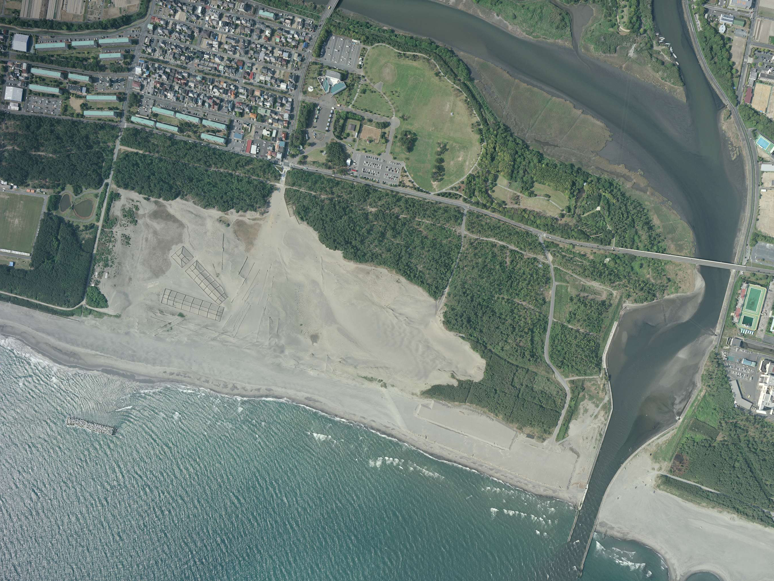
The View from Above
From the air, Nakatajima presents a striking contrast: the pale buff ribbon of sand pressed between Hamamatsu's dense urban grid to the north and the deep blue Pacific to the south. The dunes' east-west orientation along the coast is unmistakable, and on clear days the sediment plumes near the Tenryu River mouth hint at the geological process that built this place. The scale of what has been lost is also visible -- the gap between the city's edge and the waterline is narrower than historical photographs suggest it should be. It is a landscape caught between forces: the mountains that created it, the dams that starve it, and the people who are trying, one truckload of sand at a time, to keep it from vanishing entirely.
From the Air
Located at 34.665N, 137.742E on the Pacific coast south of Hamamatsu. The dunes are a distinctive pale strip between the urban area and the ocean, best viewed at low altitude on a north-south pass. Hamamatsu Air Base (RJNH) is approximately 3 nm to the north. Shizuoka Airport (RJNS) lies about 25 nm to the east. The Tenryu River mouth is visible just to the east. Expect sea breezes and potential haze along the coast.