Nakore Mosque
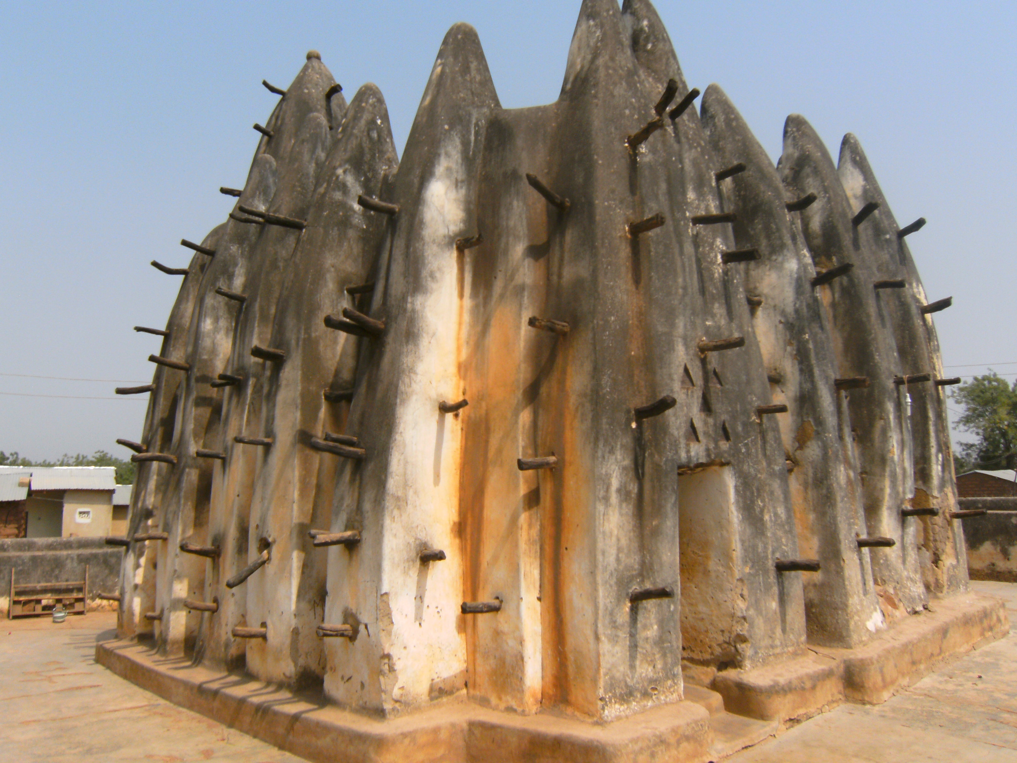
The timbers poke outward like the quills of a porcupine. They are not decorative -- or rather, they are decorative now, but they began as scaffolding. When the builders of the Nakore Mosque plastered its mud walls in the early 17th century, they left the wooden supports protruding so they could climb back up and replaster when the rains eroded the surface. Four centuries later, those timbers still jut from the parapet, a construction technique frozen in place, as practical and elegant as the day the mud dried.
Following the Songhai Roads
The mosque exists because trade routes existed first. In the early 17th century, Mande warriors followed the old Songhai trading paths south from Bobo-Dioulasso, in present-day Burkina Faso, through Wa and onward to Kumasi. Islam traveled with them, taking root in the settlements along these north-south corridors. The village of Nakore, southwest of Wa in Ghana's Upper West Region, was one such settlement. The mosque the Mande community built there was not a grand statement of imperial power but a local house of prayer, scaled to the village, built from the earth beneath it. It belongs to the Sudano-Sahelian architectural tradition -- a building style that stretches across the Sahel from Djenne in Mali to Agadez in Niger, adapted here to the conditions of the Guinea savannah.
Mud, Timber, and Geometry
The Nakore Mosque is compact and irregular, shaped more by intuition than blueprint. A timber-frame structure supports the flat roof, which is packed mud over a framework of bush poles. The external walls are a series of irregularly shaped buttresses topped with pinnacles that rise above the parapet, giving the building a bristling, organic silhouette against the sky. Two towers stand taller than the buttresses. One faces east and contains a small prayer room called a haluwa -- a private meditation space within the communal structure. Above the entrances, triangular recesses are carved into the mud, adding geometric detail to the otherwise rough-hewn surfaces. The protruding timbers that serve as permanent scaffolding are the mosque's most recognizable feature, a reminder that this is a building designed to be maintained by the same community that prays inside it.
Six That Survive
The Nakore Mosque is one of only six remaining Sudano-Sahelian style mosques in Ghana that are still in use. These mud-brick structures require constant upkeep -- replastering after each rainy season, replacing timbers weakened by termites, reinforcing walls that sag under their own weight. The skill to maintain them is itself endangered; fewer artisans know the techniques of traditional mud construction, and communities often lack the resources to undertake annual repairs. What makes Nakore remarkable is its persistence. The mosque remains an active place of worship, not a museum piece. Worshippers gather beneath the same flat roof that sheltered their ancestors, praying in a building that embodies the cultural and religious blending of the Sahel -- where Islam, Mande trading culture, and local Wala traditions converge.
Above the Upper West
Nakore sits in the Upper West Region, a sparsely populated area of rolling savannah and scattered farming communities between Wa and the Burkina Faso border. From the air, the village is a small cluster of compound walls and thatch roofs amid red-brown earth and dry-season stubble. The mosque itself is difficult to spot from high altitude -- it is modest in scale, built from the same material as the ground it stands on. But at lower altitudes, its distinctive silhouette of buttresses and projecting timbers distinguishes it from the surrounding structures. Wa Airport (DGLW) is the nearest airstrip, roughly 25 kilometers to the northeast. The landscape is flat and open, and in the dry season the harmattan haze can soften the horizon into a pale, milky band.
From the Air
Coordinates: 10.0603N, 2.5101W. Located in the village of Nakore, southwest of Wa in Ghana's Upper West Region. Wa Airport (ICAO: DGLW) is the nearest airfield, approximately 25 km northeast. Flat savannah terrain at roughly 300m elevation. The mosque is small and built from local mud, making it difficult to distinguish from surrounding structures at high altitude. Best viewed at lower altitudes. Dry season (Nov-Mar) offers clearest conditions, though harmattan dust may reduce visibility.