Nansi Lake
Nansi Lake is not really one lake. It is four: Weishan, Zhaoyang, Nanyang, and Dushan, connected into a single body of water stretching 120 kilometers through Shandong Province. Together they form the largest freshwater lake in northern China, covering 1,266 square kilometers. But this vast sheet of water is surprisingly young by geological standards. Most of it did not exist before the 1560s, when engineers rerouted the Grand Canal and the Yellow River's floods reshaped the drainage of an entire region. Nansi Lake is less a natural feature than a monument to the unpredictable relationship between Chinese civilization and the rivers it has spent millennia trying to control.
Born from the Canal
The oldest of the four lakes, Zhaoyang, appears in records from the Yuan dynasty, when it was known as Shanyang Lake. The early Ming dynasty dredged it as a reservoir, and by then it stretched 80 li long between Teng County and Pei County, sitting on higher ground east of the Grand Canal, an ideal natural cistern. Sluices were built at the lake mouths in 1410 and rebuilt in 1494. But the Yellow River, never cooperative, sent a major flood into Zhaoyang Lake in 1528, filling it with sediment and shrinking it to a fraction of its former size. A second catastrophic flood in 1565 likely split it in two. Then, in May 1567, construction finished on a new section of the Grand Canal, diverting the waterway 15 kilometers east of its former course. This single act of engineering transformed the regional hydrology, leaving Zhaoyang Lake stranded on the canal's west side and creating the conditions for Dushan and Weishan Lakes to form.
Four Lakes Become One
The creation of the other lakes is a tangled story of engineering and accident. Dushan Lake was dug as an artificial reservoir to control stormwater runoff from the Shandong hills, while Weishan Lake formed alongside two smaller bodies called Chishan and Lumeng. Contemporary sources confused their names constantly. The first definitive mention of all four lakes as they exist today appears in 1746. By the reign of the Jiaqing Emperor in the early 1800s, Weishan, Chishan, and Lumeng had merged into a single body that took the name of Weishan Island, which sat within it. A dam built in 1960 divided the combined system into upper and lower parts, with similar surface areas of roughly 600 square kilometers each, but the drainage is lopsided: nearly 90 percent of the water flowing into Nansi Lake enters the upper portion through 29 of the lake's 53 tributary streams.
A Reservoir Under Pressure
Until the mid-1980s, Nansi Lake's water was clean enough to drink. That changed rapidly as untreated industrial and agricultural sewage poured into the drainage basin during China's economic boom. The lake that had once been compared to Little West Lake for its beauty became a cautionary tale about unregulated development. Historically, flooding was the primary concern; since the 1980s, the greater threat has been drought, driven by water diversion upstream and high consumption. Weishan Lake, the largest of the four at roughly 660 square kilometers, maintains the best water quality, with nearly 90 percent of its surface covered by aquatic plants. Its average depth is only about 2.5 meters, making it vulnerable to both drought and pollution in ways that deeper lakes are not.
Moving Water Across a Continent
Nansi Lake now plays a critical role in one of the most ambitious infrastructure projects in human history: the eastern route of China's South-North Water Diversion Project, which moves water from the Yangtze River basin to the water-scarce north, largely following and paralleling the ancient Grand Canal. The lake serves as a key reservoir along this route, a function that connects it directly to the same engineering tradition that created it in the 1560s. For five centuries, the relationship between Nansi Lake and China's canal system has been one of mutual dependence: the canals created the lake, and the lake now sustains the canals' modern successor. It is also one of Shandong Province's most important freshwater fisheries, though the fish farmers who work its shallow waters have found themselves caught between the competing demands of aquaculture and water transfer.
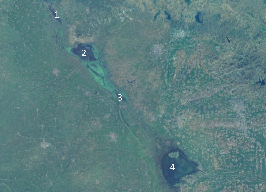
From the Air
Located at 34.6N, 117.2E in Shandong Province, the lake stretches 120 km north-south and is clearly visible from cruising altitude as a large body of water in the otherwise flat North China Plain. Weishan County administers the lake. Nearest airports include Xuzhou Guanyin International Airport (ZSXZ) to the south and Jining Da'an Airport (ZSJG) to the northwest. The Grand Canal runs along and through the lake system.