Naruko Dam: Where Carp Climb a Waterfall
Every May, something impossible appears to happen at Naruko Dam. Snowmelt from the Ou Mountains fills the reservoir past capacity, and water cascades over the dam crest in a broad, even sheet that locals call the "sudare" -- the bamboo blind discharge. On Children's Day, May 5th, colorful carp streamers are strung across the gorge in front of the falling water. From the viewing platforms, the streamers appear to be swimming upward through the curtain of spray, as if climbing the waterfall itself. It is a spectacle perfectly suited to a structure built to prove that Japanese engineers could accomplish what foreign experts said they could not.
Born from Typhoons
The Eaigawa River, the largest tributary of the Kitakami River system in Miyagi Prefecture, had flooded the agricultural plains below for as long as anyone had been farming them. Initial surveys for a dam began in 1941 but were interrupted by World War II. Then came Typhoon Kathleen in 1947 and Typhoon Ion in 1948, each devastating the farmlands of the Osaki agricultural area. In 1949, the Ministry of Construction formulated the Revised Improvement Plan for the Upper Kitakami River, and the Naruko Dam project was launched as part of the Eai River and Naruse River Revised Improvement Plan. The site chosen was a narrow point in a volcanic caldera, where the Eaigawa cuts through ancient geology before entering the famous Naruko Gorge downstream.
A Dam Without Foreign Hands
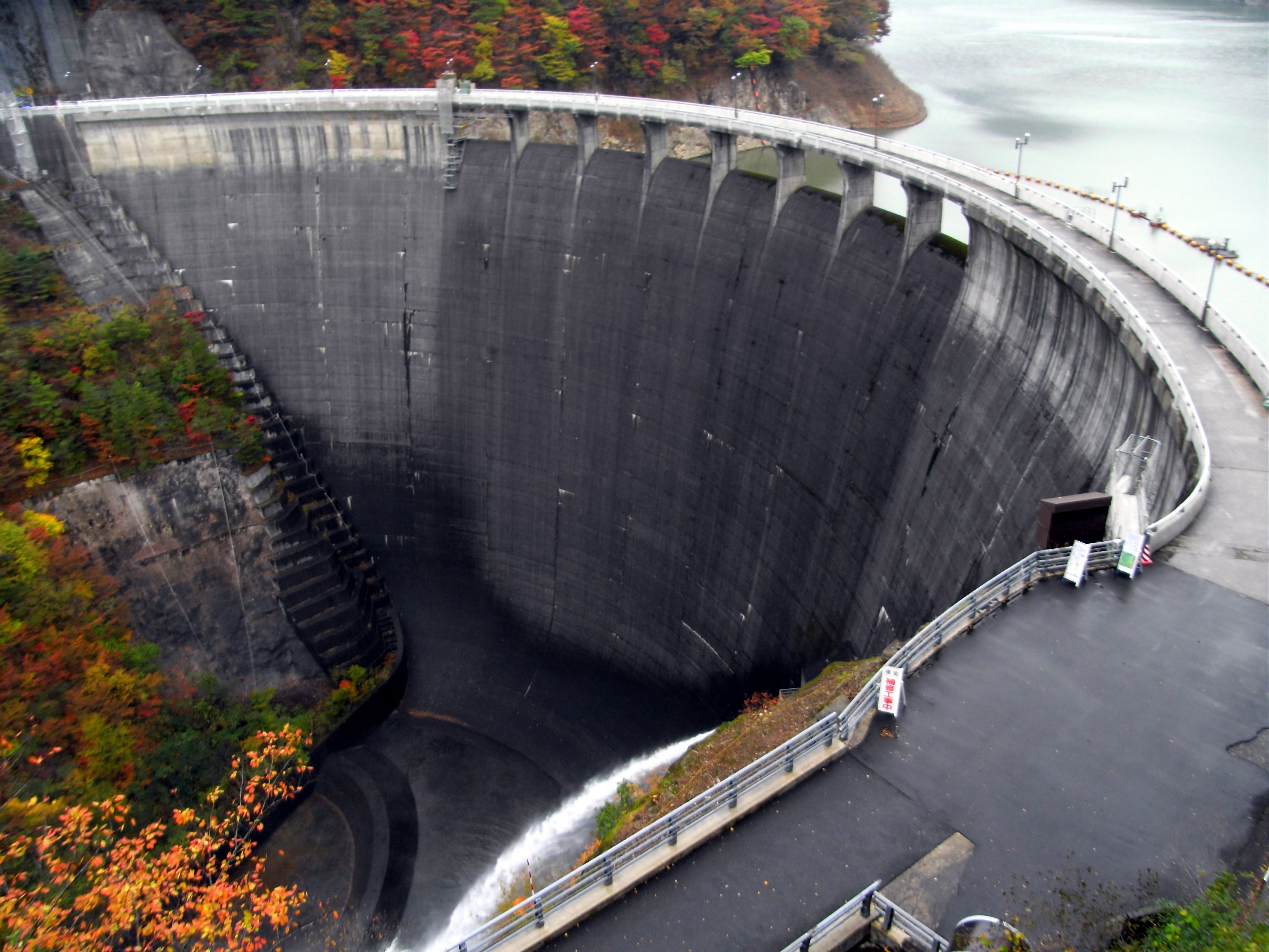
Construction began in 1951, and the dam was completed in 1958 by Kajima Corporation after seven years of work. Naruko was the third concrete gravity-arch dam completed in Japan, following the Mimoro Dam on the Hii River and the Kamishiiba Dam on the Mimi River. But it carries a distinction the others do not: Naruko was the first 100-meter class arch dam designed and built entirely by Japanese engineers, without foreign technical assistance. At 94.5 meters tall, it was an ambitious project for a team working in complex caldera terrain with volcanic geology that demanded creative engineering solutions. In 2016, the Japan Society of Civil Engineers recognized the dam as a Selected Civil Engineering Heritage site -- a formal acknowledgment that Naruko represents a milestone in the country's engineering independence.
The Lake and the Gorge
Behind the dam, the reservoir called Lake Arao fills a basin surrounded by the peaks of the Kurikoma Quasi-National Park. The lake and dam sit at the upper end of Naruko Gorge, a dramatic 100-meter-deep canyon where the Eaigawa has carved through volcanic rock over millennia. In autumn, the gorge walls ignite with some of the most celebrated fall foliage in the Tohoku region -- maple, beech, and oak painting the sheer cliffs in red, orange, and gold. Downstream from the gorge, the town of Naruko Onsen offers one of Tohoku's most renowned hot spring areas, with seven different spring types out of the ten recognized in Japan and a history stretching back over a thousand years. The dam serves triple duty: flood control for the lowland farms, irrigation water for the Osaki agricultural area, and hydroelectric generation through Tohoku Electric Power Company.
Concrete and Carp Streamers
Naruko Dam is managed by the Tohoku Regional Development Bureau of the Ministry of Land, Infrastructure, Transport and Tourism, and it remains a working piece of infrastructure -- flood gates, power turbines, irrigation intakes all operational. But it has also become a destination. The sudare discharge in spring draws crowds who come to watch the dam crest transform into a wall of falling water. The carp streamers strung for Children's Day add a surreal beauty, the fabric fish appearing to leap upstream through the mist. In autumn, the viewing platforms along the gorge fill with photographers chasing the perfect frame of crimson leaves against gray concrete and blue reservoir water. The dam is easily reached from JR Naruko-Onsen Station and sits near National Route 108, also known as the Sen-Shu Sun Line. What Naruko's engineers built to tame a river has become, unexpectedly, one of northern Miyagi's most photogenic landmarks.
From the Air
Located at 38.754°N, 140.705°E in a volcanic caldera valley in northwestern Miyagi Prefecture. The dam, Lake Arao reservoir, and Naruko Gorge are all visible from altitude as a striking sequence of water features cutting through mountainous terrain. Best viewed at 3,000-5,000 feet AGL from the south or east to see the dam face, the reservoir behind it, and the gorge downstream. Sendai Airport (RJSS) lies approximately 50 nautical miles to the south-southeast. The terrain is mountainous, part of the Kurikoma Quasi-National Park. Naruko Onsen hot spring town is visible just downstream of the gorge. National Route 108 (Sen-Shu Sun Line) follows the valley.