Naruko Volcano
In 837 AD, the ground around a mountain in northern Miyagi Prefecture began to shake. The trembling lasted days. Then the mountain exploded, sending boiling water cascading downhill like a river. The terrified villagers reported the event to the imperial court in Kyoto, which responded by enshrining a hot spring god at the site. The eruption, recorded in the Shoku Nihon Koki chronicle, gave the volcano the name it still carries: Naruko, derived from 'narugou' -- the place with a trembling sound. Nearly twelve centuries later, that trembling has produced one of Japan's most celebrated hot spring districts, a lake so acidic that nothing can live in it, and a caldera landscape that hides in plain sight.
The Caldera That Hides in Plain Sight
Naruko is a stratovolcano, but it does not look like one. Unlike Mount Fuji's iconic cone, Naruko's defining feature is a broad caldera roughly seven kilometers wide, formed by two massive pyroclastic flows 73,000 and 45,000 years ago. Four dacite lava domes rise from the caldera's center, the tallest being Mount Kurumigatake at 470 meters. But the overall profile is so subdued that a casual observer would never recognize it as a volcanic landscape. The Japan Meteorological Agency, however, classifies Naruko as an active volcano, and the geothermal energy simmering beneath the surface makes itself known through fumaroles, steaming vents, and the hundreds of hot springs that feed the villages below.
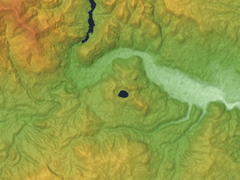
A Lake Where Nothing Lives
Katanuma sits in the center of the caldera, an emerald pool enclosed by the four lava domes. It formed roughly 18,000 years ago when an explosive eruption blasted apart one of the domes, leaving a crater that filled with volcanically heated, mineral-laden water. The lake has a pH hovering around 1.6 to 2.4, making it one of the most acidic bodies of water in Japan. No fish swim in Katanuma. No aquatic plants root along its shores. Gas still erupts where bare earth is exposed, and steam rises from the lake bottom. The water changes color with the seasons, shifting between shades of green and turquoise depending on temperature, sunlight, and volcanic gas output. It is an elliptical pool, roughly 460 meters east to west and 326 meters north to south, with neither inflowing nor outflowing streams -- a self-contained cauldron fed entirely by volcanic chemistry.
Four Hundred Springs and a Squeaking Doll
The same volcanic system that created Katanuma also produced the Naruko Onsen hot spring district, one of the largest in Japan. More than four hundred individual springs feed five distinct onsen villages -- Naruko, Higashi Naruko, Kawatabi, Nakayamadaira, and Onikobe -- offering eight of the ten recognized types of hot spring water found in Japan. The springs have drawn visitors for over a thousand years, including the haiku poet Matsuo Basho, who passed through during his famous journey to the northern provinces. The volcanic heat also sustained a community of woodworkers in the surrounding mountains, who two centuries ago began carving kokeshi dolls as toys for their children. Naruko kokeshi, designated a national traditional craft, are recognizable by their distinctive squeaking sound when you turn the head -- a phenomenon called 'gatako,' caused by frictional heat during the head-insertion technique. About fifty craftsmen still produce them by hand today.
Still Trembling
The 837 eruption remains the only historically recorded eruption at Naruko, and geologists classify it as a relatively modest phreatic event -- a steam explosion that collapsed a lava dome rather than producing fresh magma. But the volcano has not gone quiet. Volcanic gas continues to seep from the caldera floor. The extreme acidity of Katanuma testifies to ongoing geothermal activity deep beneath the surface. Naruko sits along the volcanic front of the Tohoku region, part of a chain of volcanoes generated by the subduction of the Pacific Plate beneath the North American Plate. The surrounding region experiences frequent seismic activity, a reminder that the geologic forces that built this caldera over tens of thousands of years have not finished their work. The ground still trembles, just as the chronicle recorded twelve centuries ago.
From the Air
Located at 38.733N, 140.732E in northern Miyagi Prefecture, Japan. The caldera is roughly 7 km wide but subtle from the air -- look for the emerald-green Katanuma lake as the primary visual landmark at the caldera's center. Mount Kurumigatake (470 m) is the highest of four central lava domes. Best viewed at 3,000-5,000 feet AGL to appreciate the caldera's full extent. The Naruko Onsen hot spring district sits along the southern caldera rim. Nearest major airport is Sendai Airport (RJSS), approximately 50 nm to the south-southeast. Mountain weather in the Tohoku region can produce rapid cloud buildup, especially in autumn and winter.