Naval Station Puget Sound
On September 28, 1924, two Douglas World Cruiser biplanes touched down on a grass airfield jutting into Lake Washington, completing the first aerial circumnavigation of the globe. The flight had begun 175 days earlier in the same spot, and the crowds that greeted the returning pilots helped convince Congress that this muddy peninsula on Seattle's northeast shore deserved serious investment. Sand Point would spend the next seven decades as one of the Navy's key Pacific Northwest installations, training aviators, launching patrols, and quietly leaving its mark at the bottom of Lake Washington in the form of sunken aircraft that divers still visit today.
A Park Condemned, a Base Born
The land had a civic life before the Navy arrived. In 1918, Morgan J. Carkeek donated the 23-acre peninsula around Sand Point and Pontiac Bay to Seattle for a city park. It bore his name for less than a decade. In 1926, the federal government condemned Carkeek Park for military use, paying $25,000 that the city used to establish a replacement park on Puget Sound north of Ballard. The Navy had begun construction in 1922 on a site it was leasing from King County, and by 1926 it owned the 413-acre field outright, a gift from the county valued at $500,000. The Seattle Chamber of Commerce had brokered a similar deal for the Army twenty-eight years earlier with Fort Lawton, most of which eventually became Discovery Park. Seattle, it seemed, had a habit of giving away its most scenic peninsulas to the military.
Grass, Concrete, and War
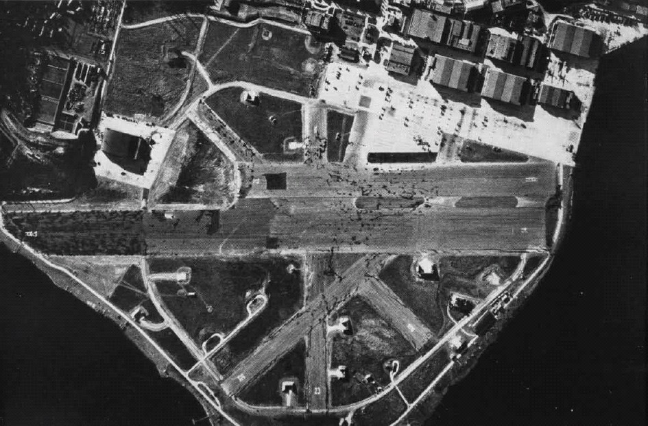
Through the 1930s, Sand Point remained a modest grass-strip facility. That changed abruptly in 1940 and 1941, when the runways were paved in anticipation of war. The primary runway, aligned 14/32, stretched just under a mile at 5,050 feet. With the United States' entry into World War II, Naval Air Station Seattle became a critical training ground for naval aviators headed to the Pacific theater. The base hummed with flight operations, maintenance crews, and the constant coming and going of trainer aircraft over the lake. Not every flight ended on the runway. Training accidents and mechanical failures sent several planes into Lake Washington, where they settled into the cold, dark water and remain to this day. A PV-2 Harpoon that crashed on approach in 1947 sits under 140 feet of water off Sand Point. A PB4Y Privateer, brought down in 1956 after its pilot missed setting the flaps, rests under 155 feet near what is now the Magnuson Park boat ramp. Local divers treat these wrecks as underwater museums.
Slow Decommission
NAS Seattle was deactivated in 1970, and the airfield went silent. The base shrank to Naval Support Activity Seattle, and negotiations began over who would inherit the surplus land. In 1975, much of the property was divided between the City of Seattle and the National Oceanic and Atmospheric Administration. The city named its portion Sand Point Park, then renamed it Magnuson Park in 1977 in honor of Warren Magnuson, the longtime U.S. senator and former naval officer from Seattle. The runways were torn up in the late 1970s. NOAA built its Pacific Marine Center on the north end, completed in 1982. The remaining installation was renamed Naval Station Puget Sound in 1986, recommended for closure in 1991, and formally shut down in September 1995. What had begun as a donated park, been taken for a naval airfield, and served through three-quarters of a century of American military history was being given back, piece by piece, to civilian life.
From Hangars to Art Studios
The former naval station was added to the National Register of Historic Places on July 2, 2010, and designated as the Sand Point Naval Air Station Historic District by the city on March 16, 2011. Rather than demolishing the old military buildings, the community found new purposes for them. Former barracks and administrative buildings have been converted into affordable housing. Old hangars host sports facilities and athletic clubs. Artist studios fill spaces that once stored equipment. A brewery operates where naval personnel once worked. The transformation is one of the more successful base-conversion stories in the Pacific Northwest, turning a decommissioned military installation into a neighborhood where people live, create, and play. The grass that now covers the old runways gives no hint of the concrete that once lay beneath, or of the biplanes that landed here after flying around the world.
From the Air
Naval Station Puget Sound (now Magnuson Park) occupies the Sand Point peninsula at 47.682N, 122.255W, projecting into Lake Washington from Seattle's northeast shore. The peninsula is clearly visible from altitude as a large green park along the western shore of Lake Washington. NOAA's Pacific Marine Center occupies the north end with distinctive white buildings. The former runway alignment 14/32 is traceable in the park's layout. Nearest airports: Boeing Field (KBFI) 8nm south, Kenmore Air Harbor (S60) 4nm north, Renton Municipal (KRNT) 9nm southeast. Best viewed at 2,000-3,000 feet approaching from the east over Lake Washington, where the full shape of the peninsula is visible against the urban grid of the Sand Point and Laurelhurst neighborhoods.