Nazca Culture
They drew pictures that only gods could see. Across hundreds of square miles of sun-baked desert along Peru's southern coast, the Nazca people scraped away red pebbles to reveal the lighter earth beneath, creating enormous figures -- a hummingbird, a spider, a monkey -- visible only from high above. The lines have survived for more than a thousand years in one of the driest places on Earth, yet the civilization that made them did not. The Nazca flourished from roughly 100 BC to 800 AD in the river valleys of the Rio Grande de Nazca drainage and the Ica Valley, leaving behind art, engineering, and mystery in almost equal measure.
Water from Stone
Farming a desert requires either audacity or desperation, and the Nazca had both. Their most remarkable engineering achievement was the puquio system: underground channels dug into mountainsides until they reached buried aquifers. The channels were lined with unmortered river rocks, deliberately left loose so groundwater could seep in. From there, water flowed through irrigation canals called acequias to feed crops, or into small reservoirs called kochas for household use. These subterranean aqueducts represent a sophistication of hydraulic engineering that allowed the Nazca to grow maize, squash, beans, peanuts, and cotton in a landscape that offered almost no surface water. Some of these puquios still function today, more than a millennium after their construction.
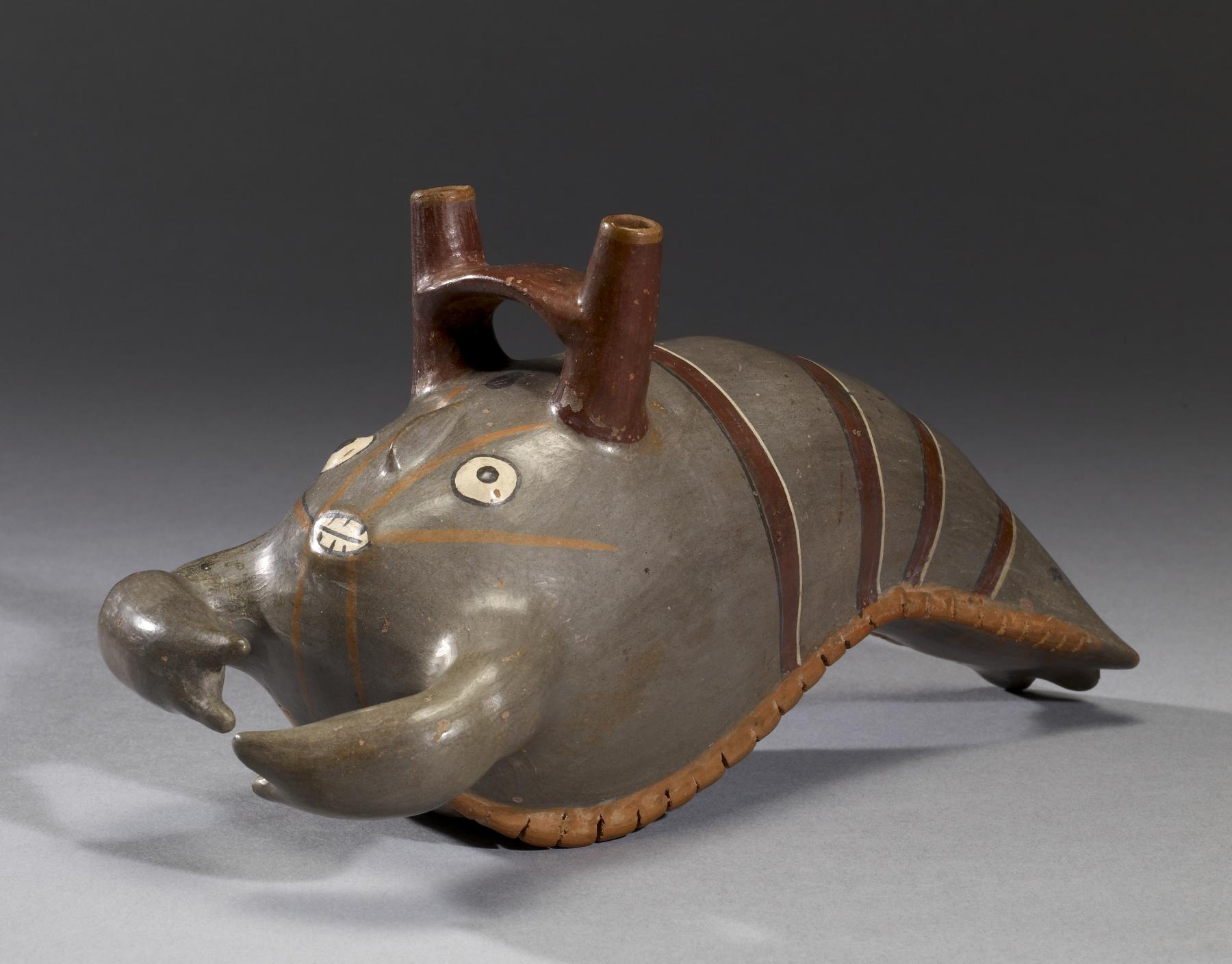
Art That Breathes
Where the preceding Paracas culture favored elaborate textiles, the Nazca turned to pottery with an intensity that produced one of the most distinctive ceramic traditions in the ancient Americas. Scholars have identified nine phases of Nazca pottery, beginning with realistic depictions of fruits, plants, animals, and people, and evolving over centuries into increasingly abstract geometric forms. Their slip-painted vessels burst with color -- depicting hummingbirds with speckled bodies, double-headed serpentine creatures, and anthropomorphic figures that blur the line between human and divine. Textiles, too, carried meaning. One mantle studied extensively by researcher Lois Martin appears to have functioned as a calendar for tracking ritual timing, its three-dimensional edging suggesting it was laid flat on the ground rather than worn or hung.
The Ceremonial Heart
Cahuachi was not a city in any conventional sense. This sprawling complex of earthwork mounds and plazas served as the Nazca world's ceremonial center -- a place for rituals and feasting related to agriculture, water, and fertility. Archaeological evidence suggests pilgrims traveled there rather than residents living there permanently; the proportion of utilitarian ceramics found at the site is too low for a settled population. Early Nazca society organized itself around local chiefdoms that radiated outward from Cahuachi's ritual authority. But by the end of Nazca phase 3 -- around 450 AD -- construction ceased and the site was abandoned. Most scholars connect this collapse to a devastating pan-Andean drought that disrupted the ceremonial cycles Cahuachi had sustained.
Lines in the Sand
The Nazca Lines remain one of archaeology's great puzzles. Spanning the desert floor, these geoglyphs include geometric shapes, straight lines stretching for miles, and animal figures some as large as a football field. Their construction was deceptively simple: workers stretched ropes between posts and cleared the dark red surface pebbles to expose the pale earth below. The contrast made the designs visible from altitude. Because the Nazca desert receives almost no rainfall, these shallow markings have endured for centuries where a single rainstorm would have erased them. Theories about their purpose range from astronomical calendars that guided planting seasons to ceremonial pathways for processions, to images created for deities gazing down from above. No single explanation has won consensus, and perhaps that is fitting for a people whose art so often merged the earthly and the divine.
The Unraveling
Around 500 AD the Nazca civilization began to decline, and by 750 AD it had collapsed entirely. The likely trigger was El Nino -- cycles of catastrophic flooding that the Nazca themselves may have made worse. To clear land for maize and cotton agriculture, they had gradually felled the Prosopis pallida trees that anchored the desert ecosystem. These trees served as ecological keystones, preventing both river and wind erosion. Without them, the landscape lay exposed to climate shocks. When El Nino floods came, irrigation systems that had sustained generations were left high and dry. By about 650 AD the Wari culture from the highlands was already asserting influence, and the final phases of Nazca pottery show Wari-influenced motifs replacing the old iconography. The desert reclaimed what water had once made possible.
From the Air
Located at 14.72S, 75.13W in the arid coastal desert of southern Peru. The Nazca Lines are best viewed from 1,500-2,000 feet AGL over the Pampa de Nazca, roughly 25 nm southeast of the town of Nazca. Nearest airport is Maria Reiche Neuman Airport (SPZA) at Nazca. The desert terrain offers excellent visibility in dry conditions. Cahuachi ceremonial site lies about 17 miles west of Nazca town along the Nazca River valley.