Neebish Island
On September 5, 1899, the steamer Douglass Houghton was heading downriver through the narrow Munuscong Channel when it collided with a barge in tow and sank. The wreck plugged the only navigable passage between Lake Superior and Lake Huron for days, stranding freighters in both directions. That single accident, remembered as the Houghton Blockade, would transform Neebish Island from an obscure river island into a pivot point of Great Lakes shipping, splitting the St. Marys River traffic into two channels that freighters still follow today.
The Leaf in the River
Neebish Island sits in the St. Marys River at the easternmost reach of Michigan's Upper Peninsula, where the waters of Lake Superior funnel southward toward Lake Huron. The Ojibwe, Odawa, and Potawatomi peoples had known this stretch of river for centuries before European contact, their Algonquian ancestors having migrated from the Atlantic coast to the Great Lakes around 1200. The island takes its name from the Ojibwe word aniibiish, meaning 'leaf,' a fitting description for this wooded landmass floating between two nations. After the War of 1812, British and American commissioners surveyed the contested border and in 1821 assigned Neebish to the United States. For a time the British boundary commissioner, Anthony Barclay, had renamed it St. Tammany Island as a diplomatic compliment, but the Ojibwe name proved more durable than any gesture of politics.
Two Channels, Two Directions
The completion of the Soo Locks in 1855 opened Lake Superior to large commercial vessels, and the St. Marys River became one of the busiest shipping corridors on the continent. All of that traffic funneled through the twisting Munuscong Channel on Neebish's east side, where the American government had blasted limestone in 1856 and again in 1905 to widen the passage. But the Houghton Blockade of 1899 exposed a critical vulnerability: one channel meant one point of failure. Work began in 1903 to deepen and widen the passage on the island's west side, and by 1908 the West Neebish Channel was open to downbound ships. The solution was elegant in its simplicity. Upbound freighters heading toward Lake Superior now take the east channel; downbound traffic moves through the west. This arrangement turned Neebish Island into a natural traffic divider, its shorelines echoing with the low rumble of passing thousand-footers to this day.
Island Life at the Edge
Neebish is really two islands: Big Neebish and Little Neebish, separated by a narrow creek locals call 'the dark hole.' Among the earliest European settlers was Major William Rains, a British national who arrived on Little Neebish in 1853 after a failed colonial venture on neighboring St. Joseph Island. For a time, Little Neebish bore his name. A saw mill operated near the creek between the two islands from 1877 to 1893, employing 150 men at its peak. Islanders established their own telephone service, the Neebish Mutual Telephone Company, in 1924, though electrical power did not arrive until the mid-1950s. A privately run car ferry began service in 1933, connecting the island's west side to the Michigan mainland. The Eastern Upper Peninsula Transportation Authority took over ferry operations in 1980, and the seasonal service remains the only way to reach the island, running every two hours during the height of summer.
A Painter's View from the Lighthouse
Pat Norton was born Pat Cook on Neebish Island in 1931, one of twelve children of the United States lighthouse keeper and his wife. Growing up with lake freighters sliding past her windows, she developed an artist's eye for the interplay of water, steel, and light on the St. Marys River. Norton became a watercolor painter whose work captured the freighters, churches, and quiet island scenes that defined her childhood. She died in 2001, but her paintings remain a visual record of a vanishing way of life. For nearly thirty years, from the late 1960s until 1993, Pine River Camp drew young canoeists from across the country to Neebish. The rustic camp featured basic cabins and a dining pavilion with log poles and a dirt floor, where meals were cooked over a campfire. Today, Neebish Island's permanent population hovers around 90 people, and the island remains mostly undeveloped, a quiet leaf adrift between two great lakes.
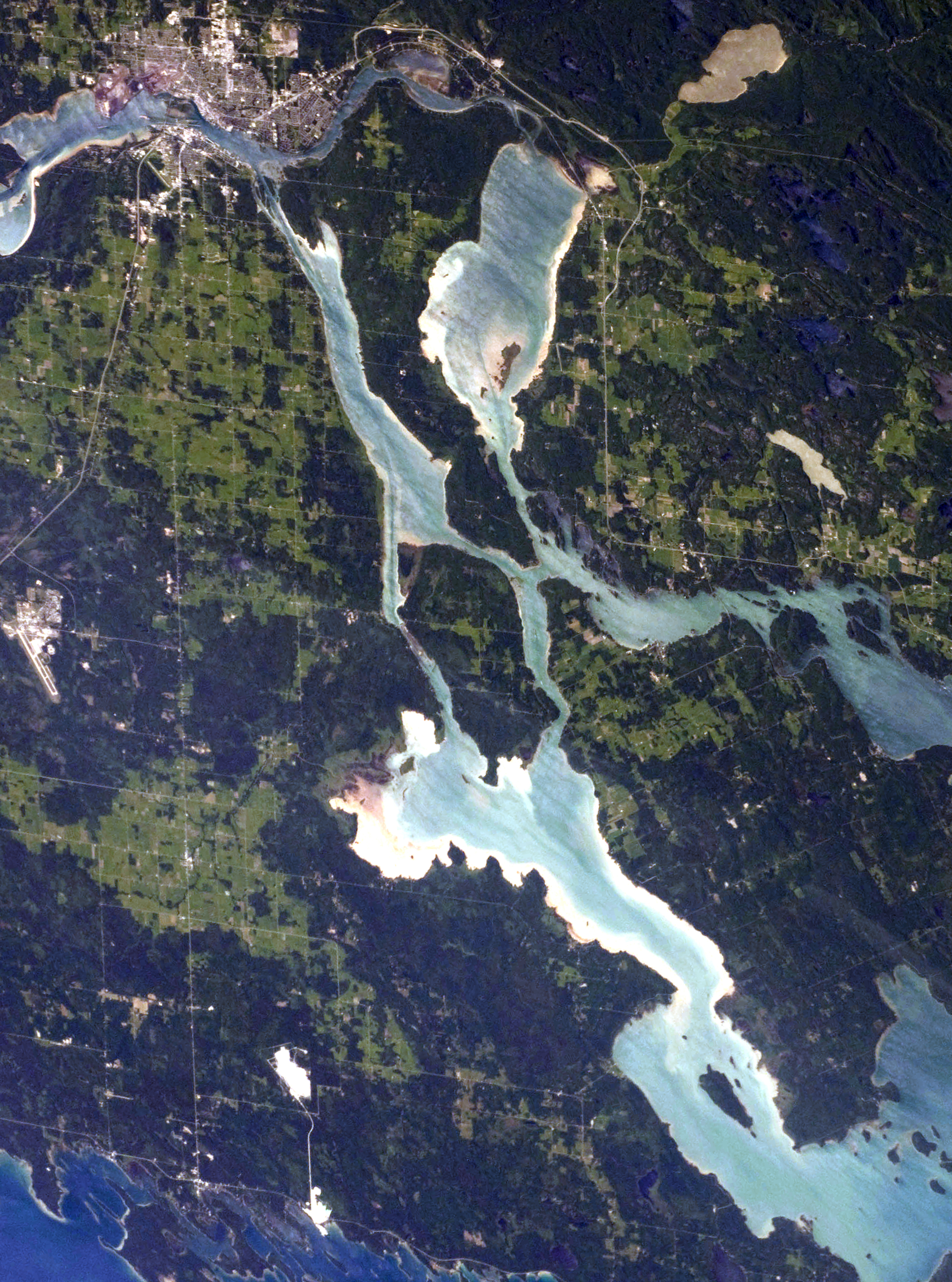
From the Air
Neebish Island (46.27N, -84.15W) is clearly visible in the St. Marys River between Michigan's Upper Peninsula and Ontario. From the air, the two shipping channels flanking the island are distinctive features. The Soo Locks and Sault Ste. Marie are approximately 15 nm to the north. Nearest airport: Sanderson Field (KANJ) in Sault Ste. Marie, MI. Sugar Island is immediately to the north, and St. Joseph Island (Ontario) lies to the east. Best viewed at 2,000-4,000 ft AGL to appreciate the ship traffic pattern.