Negril
The road from the village ran north to Green Island, straight and flat enough to double as a runway for small airplanes. Lengths of railroad track stood on end along the shoulders to discourage drug smugglers from landing to pick up cargoes of marijuana. That was Negril in the early 1970s -- a two-lane road, two white coral sand beaches, and a small village at the southern end. Half a century later, the railroad tracks are gone, but the impulse that drew people to this far western tip of Jamaica remains: the feeling of arriving at the edge of something, where the island runs out and the Caribbean takes over.
The Name and the Eels
When the Spaniards arrived in 1494, they found black eels swarming along the coast. They called the area Anguila Negra -- Black Eel -- which contracted over the centuries to Negrillo, then to Negril. The name stuck long after the eels ceased to be anyone's primary concern. Negril sits at the junction of Westmoreland and Hanover parishes, Jamaica's two westernmost districts, roughly 80 kilometers southwest of Sangster International Airport in Montego Bay. For most of its history, that distance was an obstacle. The town occupied the kind of geographic dead end -- the very tip of a westward-pointing peninsula -- that kept development at bay for centuries. What eventually arrived was not industry or agriculture but visitors, drawn precisely by the remoteness that had kept everyone else away.
Flower Children and Ferries
Negril's transformation began in the late 1950s, and it was not glamorous. Ferries dropped passengers in Negril Bay, where they waded to shore through the shallows. Most visitors rented rooms in the homes of Jamaican families or pitched tents in their yards. Daniel Connell set up the first guest house, Palm Grove, to offer something slightly more conventional for the "flower children" who had discovered the place. The first actual hotel, the Yacht Club, opened by Mary's Bay on the West End. When the road from Montego Bay was paved in the early 1970s, Negril's secret started to spread. A small airport, the Negril Aerodrome, was built near Rutland Point in 1976. European visitors began arriving alongside the North American winter tourists. The guesthouses multiplied into resorts, but the town's reputation for hospitality -- something earned in those early days of tent-pitching and room-sharing -- carried forward.
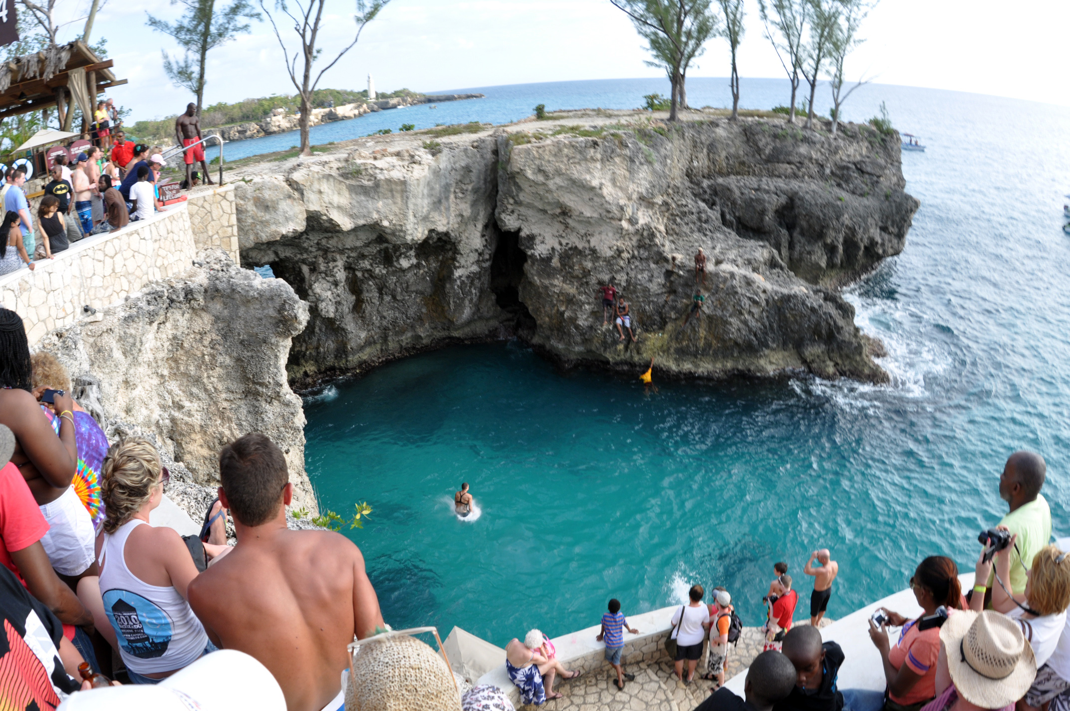
Seven Miles of Sand and Cliff
The beach is the headline. Bloody Bay to the north and Long Bay to the south together form what is called Seven Mile Beach, though the actual distance is closer to seven miles than the four miles some measurements suggest -- Bloody Bay runs about two miles, Long Bay just under five. Bloody Bay hosts the large all-inclusive resorts: Sandals, Beaches, Couples. Long Bay mixes all-inclusives with smaller, family-run hotels where the pace is different and the fences are lower. South of downtown, West End Road follows the cliffs past boutique resorts that trade beach access for privacy, snorkeling in clear water, and cliff-jumping points that reach more than 40 feet above the sea. At the western tip stands a Belgian-engineered lighthouse, still guiding ships past the rocks, with panoramic views of the point where Jamaica's coastline turns back on itself.
What Lies Behind the Beach
On the inland side of Negril's main road, hidden from the tourists watching sunsets, lies the Great Morass -- a swamp through which the Negril River winds its way to the sea. Within this wetland sits the Royal Palm Reserve, a pocket of protected forest and marshland that is Negril's ecological conscience. The coral reefs offshore have their own protector: the Negril Coral Reef Preservation Society, formed in 1990 to address degradation that tourism and development had accelerated. In 1998, the Negril Marine Park was officially declared, covering approximately 160 square kilometers from Davis Cove River in Hanover to St. John's Point in Westmoreland. The diving and snorkeling in these protected areas remain among the best in Jamaica, a reminder that the reefs existed long before the resorts and will need to outlast them.
A Place That Writes Itself Into Stories
Negril has a habit of appearing in other people's narratives. Ian Fleming set part of his 1965 James Bond novel The Man with the Golden Gun here, with the villain Scaramanga scheming to open a hotel called the Thunderbird on a Negril beach. Bob Seger name-checked it in "Sunspot Baby" in 1976. Jimmy Buffett wove it into "Jamaica Mistaica" in 1996. Even Mad Men sent characters here in a 2008 episode. The Reggae Marathon has been run annually since 2001, threading through the beach roads. Meanwhile, the government has announced plans for an international airport, a public beach park, and a craft village -- the next chapter in a town that keeps reinventing itself without ever quite losing the quality that drew those first ferry passengers to wade ashore through the shallows.
From the Air
Negril sits at 18.27N, 78.35W on Jamaica's westernmost point. The Negril Aerodrome (MKNG) is a small airstrip near Rutland Point at the north end of Seven Mile Beach. Sangster International Airport (MKJS) in Montego Bay is about 80 km to the northeast. From the air, Seven Mile Beach is unmistakable -- a long white arc separating turquoise shallows from the green interior. The Great Morass swampland is visible inland. The West End cliffs and lighthouse mark the southwestern tip. Norman Manley International Airport (MKJP) in Kingston is on the island's southeast coast.