Nelson Bay Cave
The people who sheltered here 125,000 years ago were not so different from us. They chose their tools deliberately, buried their dead in fetal positions adorned with shells and ochre, and adapted as the sea advanced and retreated across the coastal plain below. Nelson Bay Cave, cut into the quartzite cliffs of the Robberg Peninsula at Plettenberg Bay, holds one of southern Africa's longest and most revealing archaeological sequences -- a layered record of human ingenuity stretching from the Middle Stone Age through the Holocene, written in stone, bone, and the remains of meals long since consumed.
Layers of Deep Time
The cave is 18 meters wide and 35 meters deep, its opening perched 21 meters above sea level on the south-facing slope of the Robberg Peninsula. The peninsula itself -- 4 kilometers of sandstone and quartzite belonging to the Cape Supergroup -- has been carved by waves into a series of caves and overhangs. Nelson Bay Cave was among the first sites excavated in the southern Cape with the aim of tracking how terrestrial fauna responded to shifts in climate and sea level. Early excavators, working through the 1960s and 1970s, dated the stone tool industries found here to between 70,000 and 10,000 years ago using radiocarbon dating from charcoal and cross-referencing with sites like Boomplaas Cave. More recent studies using Bayesian radiocarbon models have refined these dates, filling chronological gaps that once obscured the transition from Middle Stone Age to Later Stone Age technologies.
The Robberg Industry
Nelson Bay Cave is the type-site for the Robberg Industry -- the place where this particular Later Stone Age stone-tool tradition was first studied in detail. Three distinct technological traditions are represented in the cave's deposits: the Middle Stone Age, the Howiesons Poort industry, and the Robberg Later Stone Age. The Robberg industry, dating between roughly 12,000 and 8,000 years ago, was followed by the Wilton industry around 8,000 years ago. What makes the sequence remarkable is not just its length but its completeness. Each layer tells a story of adaptation: different raw materials chosen, different flaking techniques applied, different prey pursued. The fossils embedded alongside the tools read like a census of vanished landscapes -- Cape pangolin, brown hyena, quagga, giant buffalo, and hartebeest in the older layers, giving way to bushpig, Cape buffalo, and rock hyrax as the environment shifted.
When the Sea Retreated
During the Last Glacial Maximum, the coastline moved 100 kilometers seaward and the sea level dropped 130 meters, exposing the Paleo-Agulhas Plain -- a vast grassland that stretched from the foot of the cliffs to a distant shore. From roughly 22,000 to 14,000 years ago, extensive grasslands covered the coastal plateau around Plettenberg Bay, supporting herds of grazing animals whose presence is recorded in bovid teeth found in the cave. As the ice retreated and the sea rose, the plain flooded, pushing the shoreline back toward the cave and transforming the local ecology. The changing distance from cave to coast can be read in the archaeological record itself: the abundance of fish bones and marine mollusks in certain layers tells researchers exactly when the ocean was close enough to make seafood a regular part of the diet.
The Burials at the Threshold
Among the most poignant discoveries at Nelson Bay Cave were the burials uncovered near the entrance during the earliest excavations. The remains were positioned in a fetal pose, decorated with shells and red ochre -- evidence of intentional, ritual treatment of the dead by people who inhabited the cave thousands of years ago. These burials offer a window into the inner lives of the people who called this place home: they suggest beliefs about death, care for the deceased, and social practices that went well beyond mere survival. Alongside the human remains, the cave has yielded fossils of Cape gannets, albatross, African penguins, and Cape cormorants, painting a picture of a coastline rich in seabird life, where the living and the dead shared the same windswept promontory.
Guarding the Record
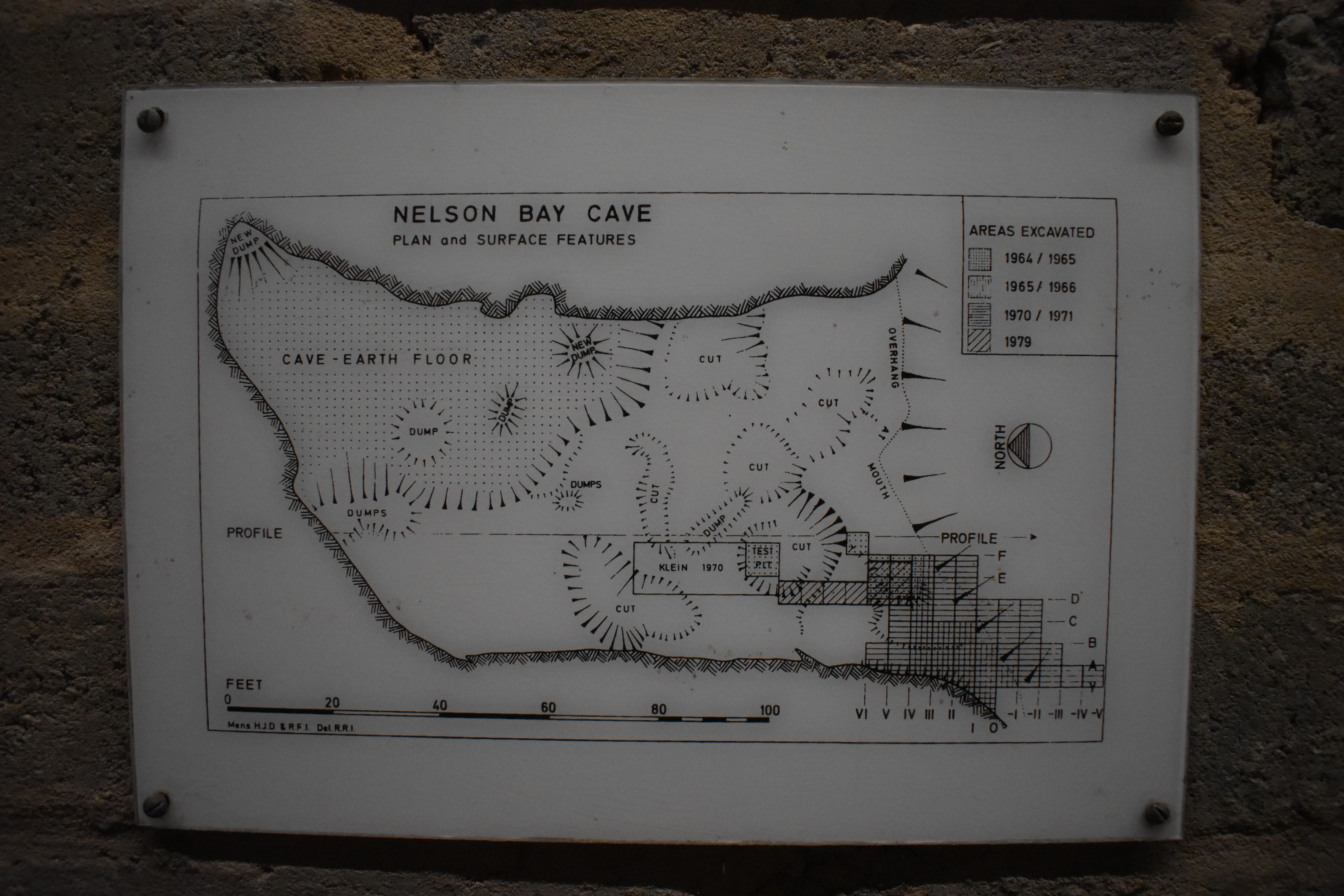
Nelson Bay Cave and the Robberg Peninsula sit within the Robberg Nature Reserve, a provincial heritage site monitored by CapeNature. In 2000, the surrounding waters were designated a marine protected area. The cave itself presented a conservation challenge: how to display an archaeological site without accelerating its erosion. In 1993, archaeologists Janette Deacon and Michael Brett proposed a protective display that included a brick wall to stabilize the excavation walls and a drainage system to divert water. Today, a walkway leads visitors to an exposed section profile from the original excavations, with illustrations explaining the story locked inside the sediments. The cave stands as both a monument to the people who lived here and a reminder that preserving the deep past requires as much care as uncovering it.
From the Air
Coordinates: 34.10S, 23.38E. The cave is located on the south-facing slope of the Robberg Peninsula, a dramatic 4-km rocky headland jutting into the Indian Ocean at Plettenberg Bay. The peninsula is clearly visible from the air. Best viewed at 2,000-4,000 ft. Nearest airports: George (FAGE), approximately 100 km west; Port Elizabeth (FAPE), approximately 200 km east. The town of Plettenberg Bay and its beaches provide orientation landmarks.