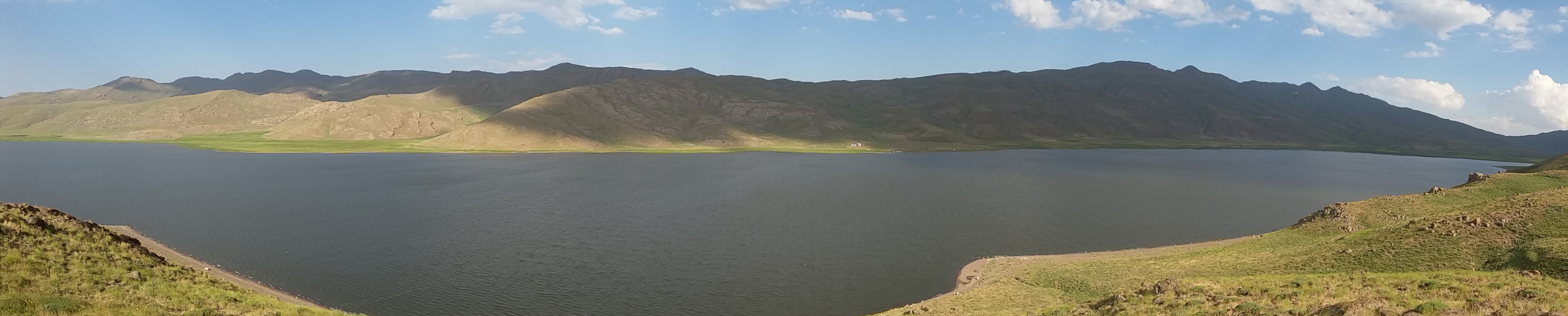
Neor Lake
Pull a core of peat from the bed of Neor Lake and you hold 6,500 years of Iranian highland history in your hands. Ancient pollen, fossilized beetles, and traces of long-vanished pastures are locked in the sediment of this shallow lake, perched in the Baghru mountain range 48 kilometers southeast of Ardabil in northwest Iran. The lake itself is unremarkable to a casual visitor -- a flat sheet of water covering 220 hectares, ringed by treeless steppe. But to paleoclimatologists and archaeologists, Neor is an open book written in mud.
Born from Fractures
Neor Lake owes its existence to geology, not rainfall. Two fault zones, active since the Eocene period tens of millions of years ago, created the tectonic depression that holds the water. The Neor fault runs along the lake's length, and a second fault defines its western shore. Together they formed a natural basin on the leeward side of the Talesh Mountains, part of the greater Alborz range. The basin receives roughly 400 millimeters of annual rainfall under a cold, mountainous climate. Heavy siltation from the surrounding slopes -- driven by erosion on gradients under 35 percent -- has gradually filled the lake, pushing it toward a eutrophic state. The water is seasonally recharged, expanding and contracting with the rhythm of snowmelt and summer drought.
Pink Trout and Orange Ducks
Despite its shallow, silty character, Neor Lake supports a surprising fishery. Rainbow trout fingerlings are introduced each year, and they thrive by feeding on Gammarus amphipods, small freshwater crustaceans that carpet the lake bed. The trout grow into robust, pink-fleshed fish prized by both commercial and sport anglers. Above the waterline, ruddy shelducks -- large, orange-brown waterfowl -- patrol the shallows alongside migrant swallows that arrive seasonally. The combination of high-altitude isolation and reliable water makes Neor an ecological oasis in a landscape dominated by dry steppe.
Reading the Ancient Steppe
The lake's greatest significance lies beneath its surface. Researchers extracted a 30-centimeter diameter core of peat from the northeastern corner of the lake bed and subjected it to pollen analysis and dating. The results revealed a 6,500-year-old sequence of pollen and beetle remains. Coprophagous beetle species -- insects that feed on animal dung -- provided direct evidence of ancient pastoral activity, confirming that herders grazed livestock in these highlands thousands of years before recorded history. The pollen spectra painted a picture of an open steppe landscape remarkably similar to the modern Irano-Turanian floristic region, suggesting that the character of this highland has been stable for millennia. The findings align with archaeological evidence from the broader region and with the nearby Hyrcanian forests along the Caspian coast.
A Climate Archive
More recent geochemical and chironomid analyses have extended the climate record further back, tracing hydrological variations since the Late Glacial period. The sediments record alternating wet and dry intervals that shaped human settlement patterns across the Iranian Plateau. When drought gripped the highlands, civilizations contracted. When rains returned, pastoralists pushed higher into the mountains. Neor Lake recorded it all, quietly accumulating layer upon layer of evidence while empires rose and fell in the valleys below. For a lake that barely reaches a person's waist in places, it carries an outsized weight of history.
From the Air
Neor Lake is located at 38.00°N, 48.56°E in the Baghru mountain range of Ardabil Province, northwest Iran. The lake appears as a flat, shallow body of water surrounded by treeless steppe at high elevation. Nearest airport is Ardabil Airport (OITL), approximately 48 km to the northwest. Best viewed at 5,000-10,000 ft. The surrounding terrain is mountainous with limited vegetation, making the lake's water surface a clear visual landmark.