Netarts Bay
Twice a day, Netarts Bay nearly empties. The tide pulls 337 million cubic feet of water out through a narrow inlet, exposing more than 1,500 acres of mudflat where herons stalk and clam diggers bend. Twice a day, it refills. This rhythm -- measured, predictable, ancient -- has shaped everything that lives here and every human community that has tried to make a living from these waters. Five miles southwest of Tillamook on the northern Oregon coast, Netarts Bay is Oregon's seventh largest bay, tucked between the headlands of Cape Meares to the north and Cape Lookout to the south. It looks peaceful. Beneath the surface, it is a place where earthquakes rewrite the shoreline, oyster populations collapse and revive across centuries, and the chemistry of the Pacific Ocean is rewriting the rules of an entire industry.
The Tillamook People and the Shaking Ground
Long before European contact, the Tillamook Indians built villages on the sand spit that separates Netarts Bay from the Pacific. Archaeological excavations at Cape Lookout State Park have uncovered 13 suspected sites, including evidence of up to three major villages. Diggers found semisubterranean cedar plank houses with single-pitched roofs, fire pits ringed with cooking stones, and middens dense with the remains of daily life. Over 67,000 vertebrate specimens from at least 59 species have been recovered -- bones of birds, fish, shellfish, sea lions, sea otters, elk, deer, porpoises, and whales. These people lived well from the bay's abundance. But the sediment record tells a darker story. Sharp sand layers deposited by tsunami waves reveal that at least four major earthquakes struck within the last 3,000 years, each one dropping the marsh by one to two meters in an instant. The Cascadia Subduction Zone, lurking offshore, has periodically swallowed whole villages.
Oyster Bay's Rise and Collapse
Olympia oysters -- the only oyster species native to the West Coast -- thrived in Netarts Bay for millennia. Humans harvested them here for at least 4,000 years. When commercial fisheries arrived in the 1860s, the bay earned the nickname "Oyster Bay," and a shanty town called Oysterville sprouted along its shores. But the commercial appetite was unsustainable. Overharvesting accelerated through the late 1800s, made worse by the export of adult oysters to San Francisco Bay, where demand seemed bottomless. By the early twentieth century, the fishery had collapsed. The last known naturally occurring population of Olympia oysters in Netarts was surveyed in 1954. Field surveys in 1979 and 1992 found none at all. After the 1992 survey, the Oregon Department of Fish and Wildlife launched a restoration effort, setting out nine million oyster spat between 1993 and 1998 -- trying to rebuild what a century of greed had consumed.
Where the Ocean Turns Acid
Netarts Bay became an unlikely frontline in a global crisis. Whiskey Creek Shellfish Hatchery, one of the largest oyster larvae producers on the West Coast, sits on the bay's shore. In the late summer of 2007, the hatchery's larvae began dying en masse -- zero production for months on end. Initial testing found the bacterium Vibrio tubiashii, but the real culprit proved more fundamental. Researchers correlated the die-offs with low aragonite saturation in the incoming tidal water -- a chemical signature of ocean acidification. The Pacific's changing chemistry was dissolving the shells of larval oysters before they could form. Experiments demonstrated that aragonite saturation, more than pH alone, has the greatest impact on early shell development. The discovery at Whiskey Creek helped crack open the scientific understanding of ocean acidification's real-world consequences, turning a small Oregon hatchery into a global reference point.
Reading the Water
The crisis at Whiskey Creek forced adaptation. Scientists at Oregon State University developed monitoring instruments called "burkolators" -- named for their inventor, Dr. Burke Hales -- that measure dissolved carbon dioxide in seawater at high resolution. Originally a research tool, burkolators now operate at five shellfish hatcheries along the U.S. West Coast, giving growers real-time data on incoming water chemistry so they can time their spawning operations to avoid the most corrosive water. A survey of 86 shellfish growers across California, Oregon, and Washington found that 85 percent already considered ocean acidification a problem affecting their businesses, and 95 percent saw it as a threat to future generations. Netarts Bay, quiet and half-empty at low tide, has become one of the places where the shellfish industry is learning to survive in an ocean that is slowly, measurably changing beneath them.
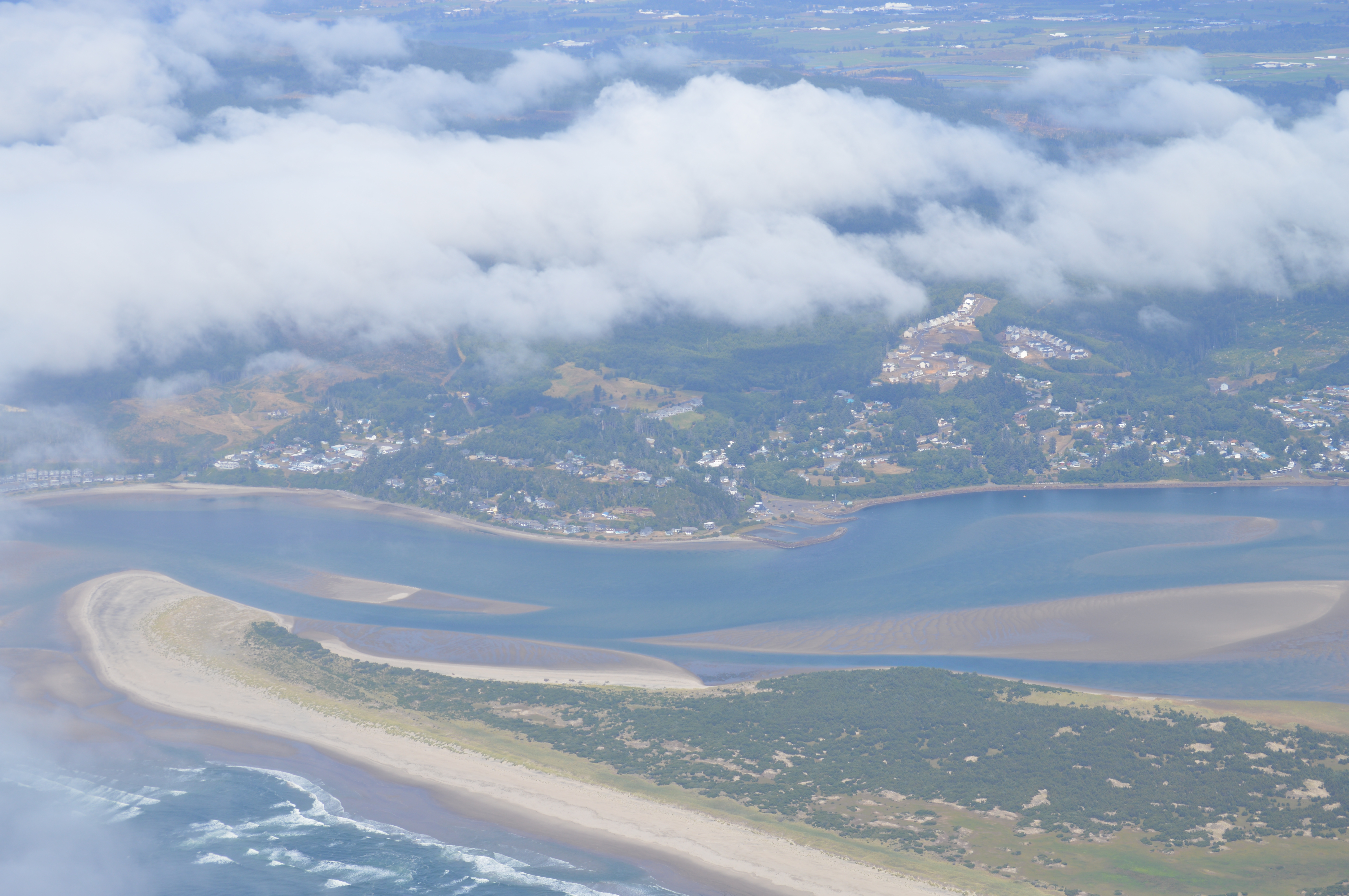
From the Air
Located at 45.40N, 123.94W on the northern Oregon coast, approximately 5 miles southwest of Tillamook. The bay is roughly 5 miles long by 1.5 miles wide, oriented north-south between Cape Meares and Cape Lookout headlands. A narrow sand spit separates the bay from the open Pacific -- look for the tidal inlet at the north end. At low tide, the exposed mudflats are dramatic from the air. Best viewed at 2,000-4,000 feet AGL. Nearest airports: Tillamook Airport (KTMK) approximately 5nm northeast, Portland-Hillsboro (KHIO) about 55nm east. Cape Lookout State Park is visible on the spit's western edge.