The Pirate Who Claimed California for England
The brass plate was supposed to settle everything. Nailed to a post somewhere along the foggy California coast in the summer of 1579, it announced in engraved English that this land -- all of it, stretching vaguely northward from the Spanish colonies -- now belonged to Queen Elizabeth I. Sir Francis Drake had just spent months plundering Spanish treasure ships in the Pacific. His hold was heavy with stolen silver and fine Chinese porcelain. What he needed was a quiet cove to scrape the barnacles off the Golden Hind before attempting something no Englishman had done: circumnavigating the globe. What he left behind was a territorial claim so sweeping it would echo through centuries of colonial history.
A Privateer's Detour
Drake's arrival on the California coast was never part of the plan. He had sailed from England in November 1577 with a commission -- likely secret, likely from the queen herself -- to raid Spanish settlements along the Pacific. The mission succeeded spectacularly, and by spring 1579 the Golden Hind was loaded with plundered treasure. Drake sailed north hoping to find the Strait of Anian, a mythical shortcut to the Atlantic about as plausible as the Fountain of Youth. Foul weather stopped him, possibly as far north as 48 degrees. With no shortcut home and a ship in need of repair, he turned south. On June 17, 1579, he found a protected cove along the Marin County coast, tucked inside Drakes Bay at Point Reyes.
White Cliffs, Foreign Shores
Drake named the place Nova Albion for two reasons. The white cliffs ringing Drakes Bay reminded him of the chalk cliffs of England's southern coast, and Albion was an ancient name for Britain itself. For five weeks, his crew hauled the Golden Hind ashore and careened her -- tipping the ship on her side to scrape and repair the hull. They built a small fort and set up camp. Francis Fletcher, Drake's chaplain and chronicler, described crossing the Inverness Ridge into a flourishing inland valley, writing that the country was "stored with many blessings fit for the use of man." He recorded animals unfamiliar to English eyes: "very large and fat Deere" -- almost certainly Roosevelt elk -- and a "strange kinde of Conies" that were likely gophers. Fletcher noted the persistent fog, the cold winds that bit through summer, and the startling warmth just over the ridge. Anyone who has visited Point Reyes on a July afternoon would recognize the description.
The Coast Miwok Encounter
The people living near Drake's anchorage were the Coast Miwok, and their meeting with the English sailors was the first recorded European contact on the California coast. Initial caution -- the Miwok approached armed with bows and arrows -- gave way quickly to daily visits. Drake's crew watched, puzzled, as the Miwok wailed and lacerated themselves. Drake interpreted this as worship, concluding the Miwok believed the English to be gods. Anthropologists now understand the behavior as a mourning ritual; the Miwok likely regarded the strangers as deceased relatives returned from the dead. In a ceremony that would carry outsized historical weight, a large assembly placed feathered chains around Drake's neck, a scepter in his hand, and a crown upon his head. England later cited this as a voluntary surrender of sovereignty -- a legal justification built on profound cultural misunderstanding. Fletcher became the first European to record any of California's 64 prehistoric language groups, writing down five Coast Miwok words: Hioh, Gnaah, Huchee kecharo, Nacharo mu, and Cheepe.
An Empire Built on a Claim
Drake sailed away on July 23, pausing at the Farallon Islands to hunt seal meat before heading west across the Pacific. He left no colonists, no garrison, no permanent structure -- just the brass plate and the claim it represented. Yet that claim proved remarkably durable. New Albion appeared on maps for centuries, designating the vast territory north of Spanish Mexico as English. The claim rejected papal authority, under which the Pope had divided the New World between Spain and Portugal. Elizabeth asserted a different principle: sovereignty through physical presence. This idea of New Albion as "the back side of Virginia" influenced colonial charters for generations. Along with Martin Frobisher's claims in Greenland and Humphrey Gilbert's 1583 claim of Newfoundland, New Albion formed one corner of England's earliest triangulation of the New World. Its final diplomatic use came as late as 1846, when Britain cited the claim during Oregon Treaty negotiations that set the U.S.-Canada border at the 49th parallel.
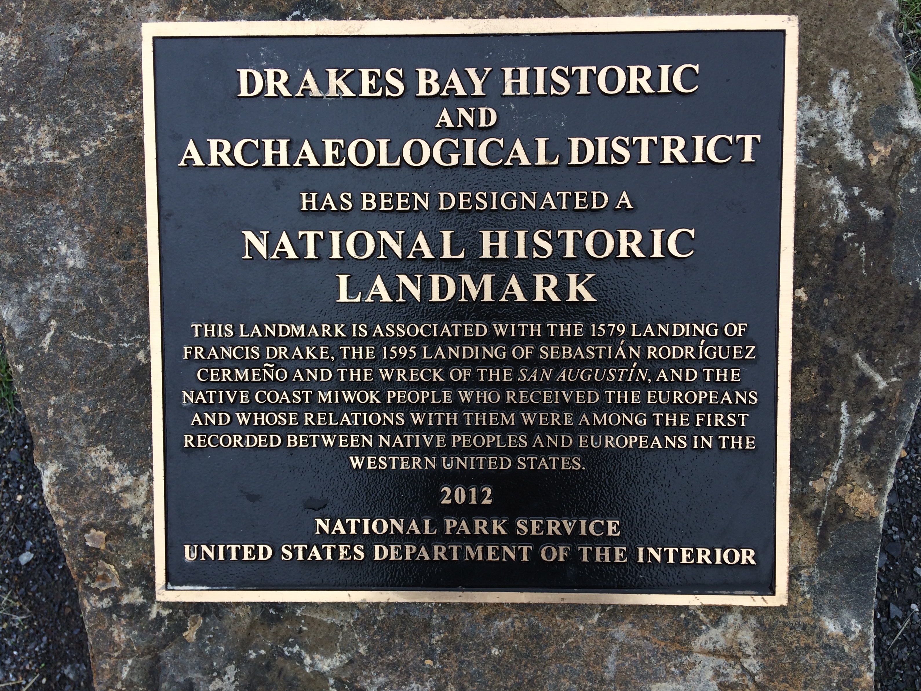
Broken Porcelain, Proven History
For centuries, the exact location of Drake's landing was debated -- more than thirty sites were proposed. The definitive evidence came not from maps or journals but from broken dishes. Nearly one hundred shards of sixteenth-century Chinese porcelain were found in Coast Miwok middens near Drake's Cove, remnants of fine Jingdezhen ware that Drake had stolen from a Spanish treasure ship. During the careening, the crew offloaded cargo to lighten the ship; the heavy porcelain, of unknown value to the English, was abandoned. Researchers distinguished these pieces from fragments of the San Agustin, a Manila galleon that sank in Drakes Bay in 1595. Drake's porcelain showed clean breaks with no surf abrasion, while the San Agustin shards were tumbled smooth by waves. In 2012, the U.S. Department of the Interior designated the site a National Historic Landmark, and in 2021 California named it Historical Landmark number 1061. The 215-acre site lies within Point Reyes National Seashore -- a quiet cove where England once tried to claim a continent.
From the Air
Located at 38.03°N, 122.94°W on the Marin County coast, approximately 30 miles northwest of San Francisco. From altitude, Point Reyes is unmistakable -- a dramatic headland jutting into the Pacific, separated from the mainland by the San Andreas Fault trace visible as Tomales Bay and the Olema Valley. Drakes Bay curves along the southern shore of the headland, with Drake's Cove (the landing site) at the inner end of Drakes Estero. The white cliffs that reminded Drake of England are visible from the air. The Farallon Islands, Drake's last stop before crossing the Pacific, lie 27 miles to the southwest. Nearest airports: San Francisco International (KSFO, 50 miles southeast), Marin County Airport/Gnoss Field (KDVO, 25 miles east). Fog frequently blankets the coastline while inland areas remain clear.