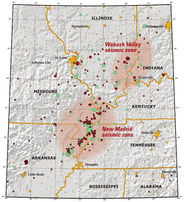
New Madrid Seismic Zone
On December 16, 1811, at approximately 2:15 AM, the ground in the Mississippi River Valley began to shake. The earthquake was so powerful that it rang church bells in Boston, 1,000 miles away. Chimneys fell in Cincinnati. The shaking continued for months - two more massive earthquakes struck in January and February 1812. The Mississippi River ran backward. Sand blows erupted across the landscape. The town of New Madrid, Missouri, was destroyed. Reelfoot Lake, in what is now Tennessee, was created when the river flowed backward into a depression. These were the most powerful earthquakes in recorded North American history, estimated between magnitude 7.5 and 8.0. The New Madrid Seismic Zone remains active. When the next major earthquake comes - and seismologists agree it will - the heavily populated modern Mississippi Valley will face devastation that 1812's sparse frontier population never imagined.
The Great Earthquakes
The first earthquake struck at 2:15 AM on December 16, 1811. Residents of New Madrid awoke to their houses collapsing. The ground rolled in visible waves. Great cracks opened in the earth, swallowing horses and cattle. Sand and water shot into the air from fissures called sand blows. Aftershocks continued for days. Then, on January 23, 1812, another massive earthquake struck. A third followed on February 7 - the most powerful of all, estimated at magnitude 7.8 to 8.0. Eyewitnesses reported the Mississippi River flowing backward as earthquake-created waterfalls temporarily reversed the current. The riverbed itself was deformed, creating rapids where none had existed.
The Devastation
The sparsely populated frontier absorbed the destruction relatively easily. New Madrid was destroyed but had only about 1,000 residents. The entire region had perhaps 30,000 settlers. Deaths were relatively few - maybe several hundred, though records are poor. But the physical transformation of the landscape was extraordinary. Tens of thousands of acres dropped several feet, flooding permanently. Sand blows created circular deposits across the floodplain that remain visible today. Reelfoot Lake, eighteen miles long and five miles wide, was created when the Mississippi temporarily reversed and flooded a forest - dead cypress trees still stand in the lake's shallow waters, their skeletal forms testimony to the earthquake's violence.
The Mystery
Why does the New Madrid Seismic Zone produce earthquakes at all? Most seismic zones occur at plate boundaries, where tectonic plates collide or slide past each other. New Madrid is in the middle of the North American plate, far from any boundary. The leading theory is that the zone marks an ancient rift - a failed attempt at continental splitting 500 million years ago - that left weakness in the continental crust. Alternatively, the stresses may result from glacial rebound, as the continent adjusts to the removal of ice sheet weight after the last Ice Age. Whatever the cause, the zone remains active. Small earthquakes occur regularly. Seismologists estimate a 25-40% probability of a magnitude 6.0 or greater earthquake within 50 years.
The Future
When the next major New Madrid earthquake occurs, the consequences will be catastrophic. The 1811-1812 earthquakes affected a frontier with few buildings and sparse population. Today, Memphis, St. Louis, and dozens of smaller cities lie within the zone. The Mississippi River is crossed by bridges and bordered by refineries, chemical plants, and nuclear facilities. Most buildings are not designed for earthquake resistance. A repeat of 1812's magnitude 7.8 event would cause tens of thousands of deaths and hundreds of billions of dollars in damage. FEMA's earthquake scenarios for the region are among the most alarming in the country. The question is not if, but when - and whether the region will be prepared.
Visiting the Zone
The New Madrid Seismic Zone stretches across southeastern Missouri, northeastern Arkansas, western Tennessee, and western Kentucky. The town of New Madrid, Missouri, has a small museum about the earthquakes and the region's history. Reelfoot Lake State Park in Tennessee preserves the lake created by the 1812 earthquakes, with excellent birdwatching (especially wintering bald eagles) and cypress swamp scenery. Sand blows - the circular sandy deposits created by the earthquakes - are visible in fields throughout the region if you know what to look for. The Big Oak Tree State Park in Missouri preserves bottomland forest in one of the areas most affected by the earthquakes. Memphis International Airport (MEM) is the nearest major airport to most sites. The landscape is flat, agricultural, and unremarkable - until you realize you're standing on one of the most seismically active zones in North America.
From the Air
Located at 36.59°N, 89.53°W in southeastern Missouri, along the Mississippi River where Missouri, Kentucky, Tennessee, and Arkansas meet. From altitude, the New Madrid Seismic Zone is indistinguishable from surrounding agricultural land - flat floodplain planted in soybeans and cotton. Reelfoot Lake is visible as an irregularly shaped body of water in Tennessee. The Mississippi River meanders through the zone.