New Providence
By 1713, the pirates outnumbered the law-abiding residents two to one. Over a thousand of them had settled in Nassau, on an island barely 21 miles long, and one of them - a man named Thomas Barrow - had declared himself Governor of New Providence. There was no one to stop him. The forts had been abandoned, the cannons unmanned, the colonial authorities somewhere between absent and irrelevant. New Providence had become, in practical terms, a pirate republic. Five years later, Woodes Rogers arrived with a royal pardon in one hand and the threat of execution in the other, and the pirates grudgingly chose legitimacy. It was not the first time this small island reinvented itself, and it would not be the last. The Lucayan people had called it Nema - "middle-water" - long before any European arrived. Today, nearly three-quarters of the Bahamas' entire population lives here, packed onto 80 square miles of coral limestone that has somehow managed to be, at various points in its history, a pirate den, a strategic military prize, a blockade-runner's port, a bootlegger's paradise, and the most visited tourist destination in the Caribbean.
Charles-Town Burns
New Providence's European history is a cycle of building and destruction. The first lasting settlement came in 1666, and by 1670 the town of Charles-Town held over 900 residents. Then it burned. The Spanish razed it in 1684, and the colonists scattered. Two years later, English settlers from Jamaica arrived, rebuilt, and were told by Jamaica's governor to come home. They ignored the order. In 1695, Governor Nicholas Trott laid out the town again, renaming it Nassau in honor of William of Orange-Nassau, who had become William III of England. He built a fort by the same name. The Spanish damaged it in 1700. A combined French and Spanish attack in 1703 drove the colonists out entirely. Without soldiers or cannons, the empty fort became an open invitation, and the pirates accepted. For the next fifteen years, Nassau belonged to whoever was bold enough to claim it.
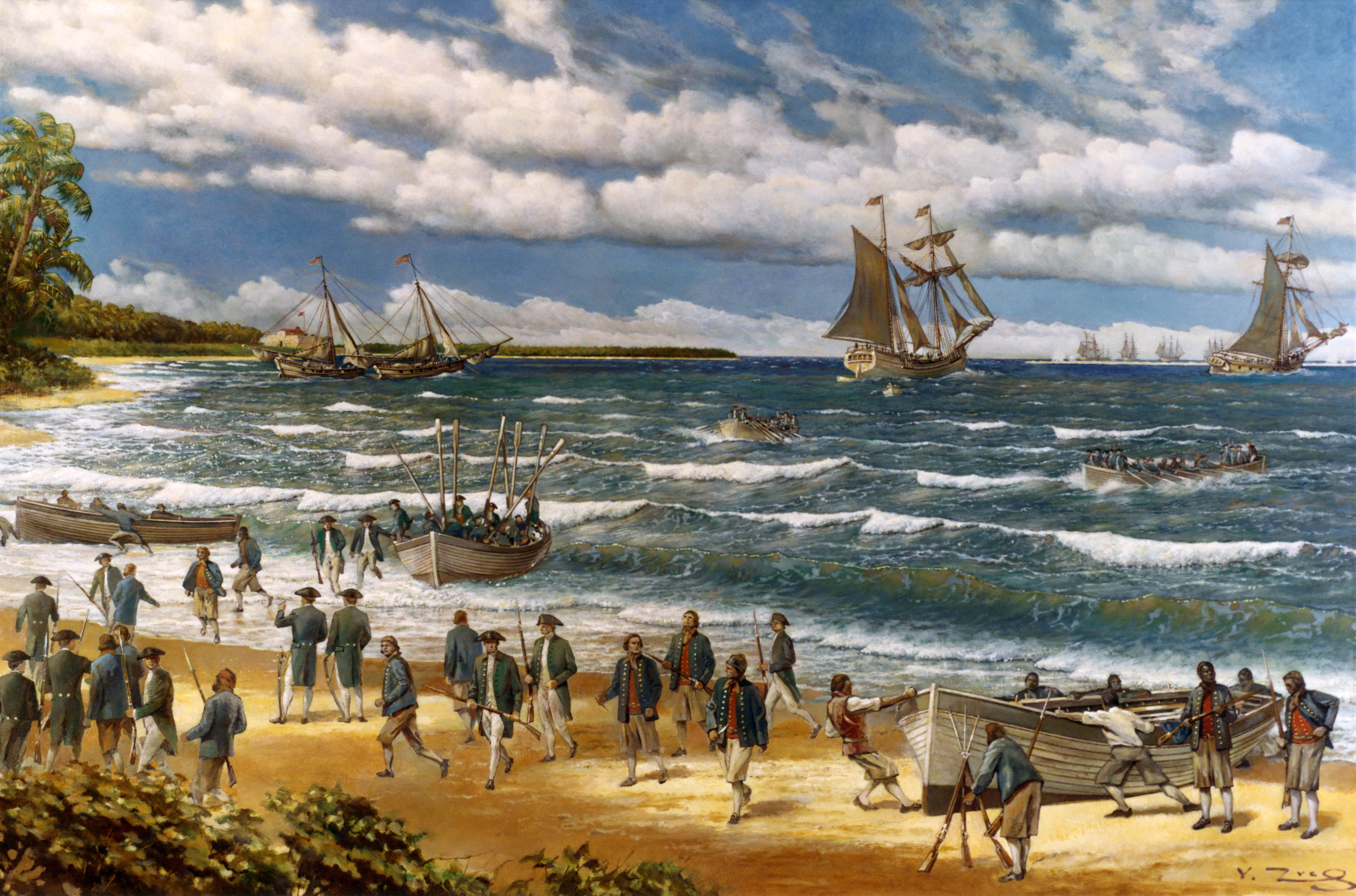
America's First Amphibious Assault
The American Revolution reached New Providence in March 1776, when Commodore Esek Hopkins led a squadron of seven ships to raid the British-held island. What followed was the first amphibious assault in American military history: 250 Continental Marines and sailors landed under covering fire from the Providence and the Wasp, overwhelmed Fort Montague, and forced the British at Fort Nassau to surrender. The Americans secured 88 cannons and 15 mortars, though most of the gunpowder they had come for had been evacuated before capture. Hopkins spent two weeks loading his ships before sailing home.
New Providence changed hands twice more during the war. In 1782, the frigate South Carolina joined a Spanish force of 59 vessels under Bernardo de Galvez, sailing from Havana. By May 8, the British colony had surrendered again - the third foreign capture of the island during the Revolutionary War alone. After the war, thousands of Loyalists and their enslaved people emigrated to New Providence, hoping to establish plantations. The shallow soil and sparse rainfall defeated them. By the early 1800s, the Bahamas had become a nearly vacant archipelago, and New Providence survived only because of its British military garrison.
Smuggler's Fortune
New Providence has a talent for profiting from other nations' troubles. During the American Civil War, Nassau became one of the busiest ports for blockade-runners supplying the Confederacy. Cotton went out, weapons and supplies came in, and Bahamian merchants grew rich on the commissions. When that war ended, prosperity faded - until Prohibition handed the island another opportunity. From 1920 to 1933, New Providence became a smuggling center for distilled spirits bound for the dry United States. Warehouses filled with whiskey and rum. Fast boats ran the short passage to Florida under cover of darkness. The pattern was unmistakable: whenever America made something illegal, Nassau made money.
But the island's most durable reinvention was already underway. By the late 19th century, New Providence had begun marketing itself as the "sanitarium of the western hemisphere," promoting its mild climate, warm winters, and English-speaking population. Steam ships ran regular routes from the American South and Cuba. By the late 1920s, the island had hotels, a deepened harbor for cruise ships, and the beginnings of the tourism industry that would eventually eclipse everything else.
Middle-Water, Modern Capital
The Lucayan word Nema, meaning "middle-water," captured something essential about New Providence that remains true today. The island sits in the middle of everything - between North America and the Caribbean, between the Atlantic and the shallow Bahama Banks, between the 700 other islands of the archipelago that depend on it as their capital and commercial hub. All three branches of Bahamian government are headquartered here. More than 400 banks and trust companies operate from Nassau. The island's hotels and port account for more than two-thirds of the four million-plus tourists who visit the Bahamas annually.
New Providence is the only part of the Bahamas that lacks local government - national authorities handle local affairs directly, dividing the island into 24 supervisory districts. From Lyford Cay's gated wealth on the western tip to the dense neighborhoods of Grants Town and Bain Town, from the resort towers of Cable Beach to the quiet settlement of Adelaide, the island packs an entire nation's contradictions into 80 square miles. Paradise Island, connected by a bridge, adds the casinos and mega-resorts. The population reached 292,522 at the 2022 census. Nema, the middle-water, has become the center of gravity for an entire nation.
From the Air
Located at 25.03°N, 77.41°W, New Providence is a roughly 21-mile-long, 7-mile-wide island clearly visible from cruising altitude. Lynden Pindling International Airport (MYNN/NAS) on the western end is the primary gateway, with runways 14/32 (11,000+ ft) handling international traffic. Paradise Island and its two bridges are unmistakable landmarks east of the harbor. Cable Beach resort strip runs along the north shore west of Nassau. From altitude, the contrast between the deep blue Atlantic to the north and the shallow turquoise Bahama Banks to the south is striking. Expect tropical weather; trade winds typically from the east-southeast. The island sits roughly 185 nautical miles east-southeast of Miami (KMIA). Fort Montague and Fort Charlotte remain visible as historic landmarks along the coastline.