New River Gorge National Park and Preserve
The name is a geological joke. The New River is one of the oldest rivers in North America, possibly the oldest on the continent, and it flows north -- the opposite of what most eastern rivers do. Originating in North Carolina, it cuts through Virginia and into the mountains of southern West Virginia, where it has spent millions of years carving the longest and deepest gorge in the Appalachian Mountains. In December 2020, this stretch of whitewater, sandstone cliffs, and ghost towns became America's 63rd national park, the newest designation protecting one of the continent's most ancient waterways.
Deep Time in Sandstone
The gorge is a cross-section through geological history. Flowing water has exposed layers of sandstone and shale, with house-sized boulders scattered from rim to river, plant and invertebrate fossils embedded in the rock face, and steep channel drop-offs that punctuate the river's descent. Four seams of coal lie exposed in the gorge walls -- bituminous coal once considered among the best in the world. This smokeless New River coal fed the boilers of the nation's trains, factories, and naval fleets, while its coke fueled iron furnaces across the industrial age. The geology of the Appalachian Plateau is written in these walls, readable from any overlook along the rim.
Ghosts of the Coal Boom
The railroad arrived in the New River Gorge in 1873 and transformed the region overnight. Within decades, more than 50 company-owned mining towns lined the gorge, their residents extracting coal from the New River Coalfield to power American industry. Thurmond became a railroad hub, its depot handling more freight revenue than Cincinnati or Richmond. Today, the park holds the remains of that era -- old rail depots, steel and timber trestle bridges, rusting equipment, and the stone coke ovens of the Nuttallburg Coal Mining Complex. At Kaymoor, trails descend past abandoned mine structures clinging to the gorge walls. The ghost town of Hamlet preserves the ruins of the lumbering industry. These are not manicured museum exhibits but raw remnants, half-claimed by forest, telling the story of extraction and abandonment that defines much of Appalachia.
A Living Gorge
Below the industrial ghosts, the gorge harbors extraordinary life. The park sits at the core of a globally significant forest containing the most diverse flora of any river gorge in central and southern Appalachia. Forty different plant communities hold at least 1,342 species and 54 rare plants. The river and its tributaries support distinct populations of native fish found nowhere else, along with mussels, crayfish, and 48 known species of amphibians, including the endangered eastern hellbender. At least 63 mammal species shelter in the gorge, among them the endangered Virginia big-eared bat and Indiana bat. Abandoned mine portals have become refuges for bats, amphibians, and the Allegheny woodrat, a species in decline across the eastern United States. Each fall, thousands of hawks ride the thermals through the gorge along the north-south migratory flyway.
Vertical Playgrounds
Climbers know the gorge simply as "The New." Over 1,400 established rock routes scale the Nuttall sandstone cliffs just below the gorge rim -- hard, featured rock offering crack climbs, face routes, and occasional large roof problems. Most routes are single-pitch, with the majority rated 5.10 to 5.12 on the Yosemite Decimal System, split roughly evenly between traditional and sport climbs. Below the cliffs, the Lower Gorge delivers Class III to V whitewater rapids from April through October, with commercial outfitters running trips through boulder-choked channels demanding precise maneuvering in powerful currents. The upper river offers gentler Class I to III water for canoeists. On the third Saturday in October, Bridge Day shuts down the New River Gorge Bridge -- a steel arch spanning 3,030 feet -- and opens it to rappelling, ascending, and BASE jumping, the only day of the year pedestrians are allowed on the structure.
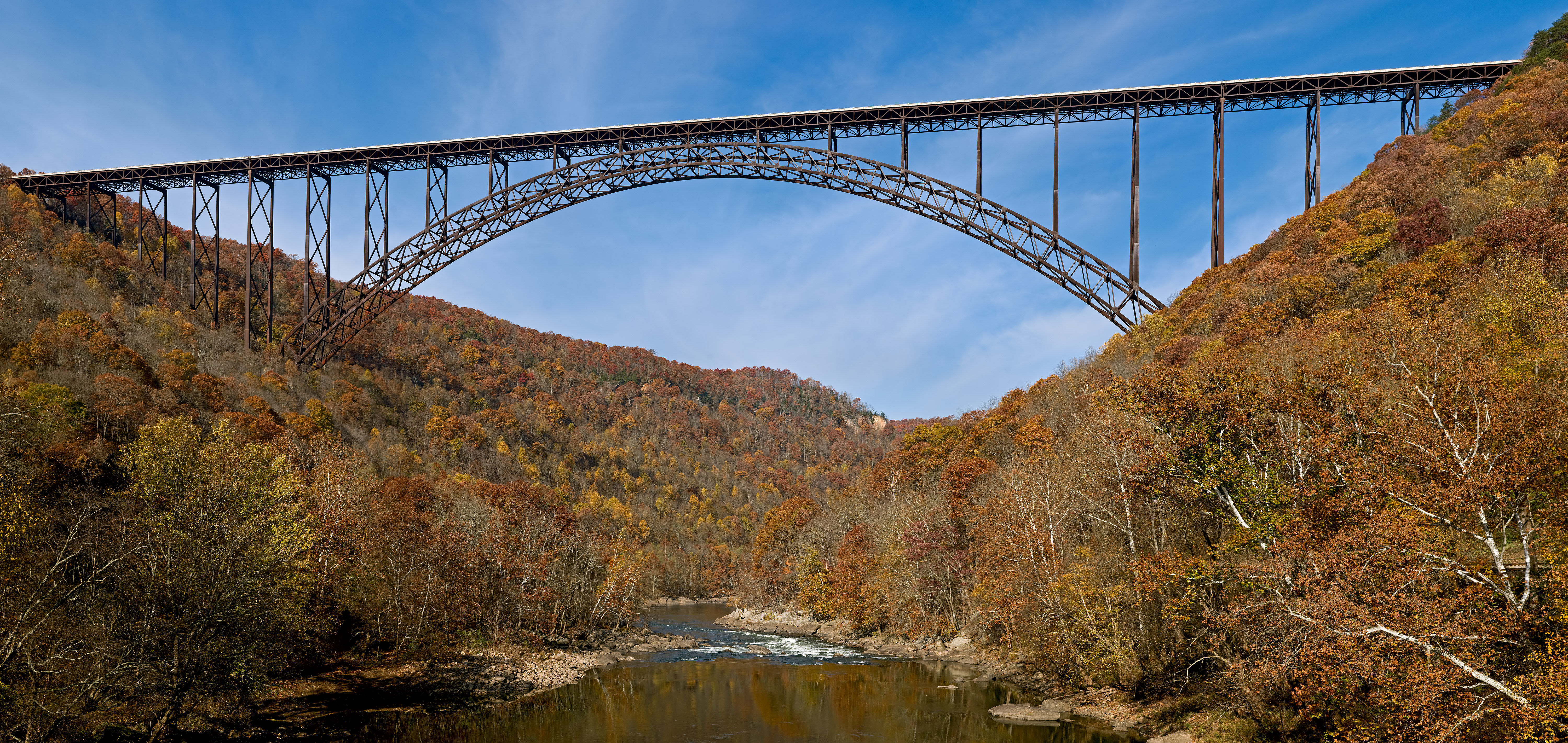
The Bridge and the View
The New River Gorge Bridge dominates the park's visual identity. Completed in 1977, the steel arch bridge carries U.S. Route 19 across the gorge at a height that makes it one of the longest single-span arch bridges in the Western Hemisphere. From the Canyon Rim Visitor Center, the bridge frames the gorge in a single sweeping view. The Long Point Trail offers hikers a head-on perspective of the span from across the gorge. For those willing to walk the maintenance catwalk beneath the bridge deck, guided tours reveal the engineering up close. The park stretches from downstream of Hinton to Hawks Nest State Park near Ansted, with year-round visitor centers at Sandstone and Canyon Rim, seasonal centers at Grandview and Thurmond Depot, and eight primitive camping areas scattered through the preserve. President Jimmy Carter established the area as a National River in 1978; in 2020, it earned the full national park designation.
From the Air
New River Gorge National Park is centered at approximately 37.961N, 81.082W in southern West Virginia. The gorge is unmistakable from the air -- look for the deep, winding river canyon cutting through heavily forested Appalachian terrain. The New River Gorge Bridge (U.S. Route 19) is the dominant visual landmark, a massive steel arch spanning the gorge. The park extends from Hinton in the south to Hawks Nest State Park near Ansted in the north. Nearest airports include Yeager Airport (KCRW) in Charleston, WV approximately 50 nm northwest, Greenbrier Valley Airport (KLWB) approximately 40 nm southeast, and Raleigh County Memorial Airport (KBLF) in Beckley approximately 20 nm south. Best viewed at 3,000-5,000 ft AGL to appreciate the gorge depth and the bridge's scale against the canyon.