Newark Light Rail
In 1935, workers opened a subway beneath Newark that no one had to dig very deep to build. The hard part had already been done a century earlier — by the mule teams and laborers who cut the Morris Canal through New Jersey's landscape, hauling iron ore and coal across mountain ridges with inclined planes and rope. When the canal's commercial era ended, the ditch was simply filled in. Engineers looked at that arrow-straight right-of-way through the heart of Newark and saw something ready-made. The Newark City Subway opened on May 26, 1935, running trains through tunnels that followed the old canal's path almost exactly. Sixty-seven years later, it grew into the Newark Light Rail — a system that today connects Penn Station to the suburbs of Bloomfield along corridors that echo two centuries of industrial ambition.
The Canal That Became a Railway
The Morris Canal was one of the engineering marvels of its era. Opened in 1831, it stretched 107 miles across New Jersey, lifting and lowering boats over the Kittatinny Mountains using a system of inclined planes — sloped ramps where cable-driven cars carried entire canal boats up the hillside. The canal carried anthracite coal west to east, feeding the furnaces and factories of the industrial northeast. But by the late 19th century, railroads had made it obsolete. The canal was drained and sold in 1924, and Newark wasted little time repurposing the bed. When Works Progress Administration crews finished building the subway in 1935, they decorated the underground stations with Art Deco murals depicting scenes of life on the defunct canal — bargemen, inclined planes, iron-laden boats. Riders today pass those images without necessarily knowing what they represent: a ghost waterway, painted into the walls of the tunnel that replaced it.
Subway Surface
The Newark Light Rail is what transit engineers call a 'subway-surface' line — a hybrid that dips underground in the dense urban core and emerges into open air as the city thins out. From Newark Penn Station, trains run through tunnels beneath the streets, past the old Military Park station (originally called Broad Street), and surface north of Warren Street. Above ground, the tracks follow the landscape through residential neighborhoods, crossing streets at grade, sharing the urban fabric with everything else that moves through Newark. Penn Station itself sits at the system's hub, connecting the Light Rail to PATH trains bound for Manhattan, NJ Transit rail lines heading in every direction, Amtrak, and dozens of bus routes. For a city of Newark's density, that convergence of transit modes at one point is a rare and useful thing.
Extension Into the Suburbs
The line's reach expanded dramatically in 2002, when a 2.1-mile extension pushed northeast into Belleville and Bloomfield along the former right-of-way of the Erie Railroad's Orange Branch. New stations at Silver Lake and Grove Street gave suburban commuters direct rail access into central Newark for the first time in decades. The extension also necessitated a new vehicle maintenance facility, which in turn drove the choice of corridor — planners needed a place to store and service the system's new low-floor light rail vehicles. Old railroad alignments, like the canal beds before them, proved too valuable to waste. Newark's transit geography is layered this way: each new system inherits the footprint of whatever came before, repurposing infrastructure that earlier eras built for entirely different purposes.
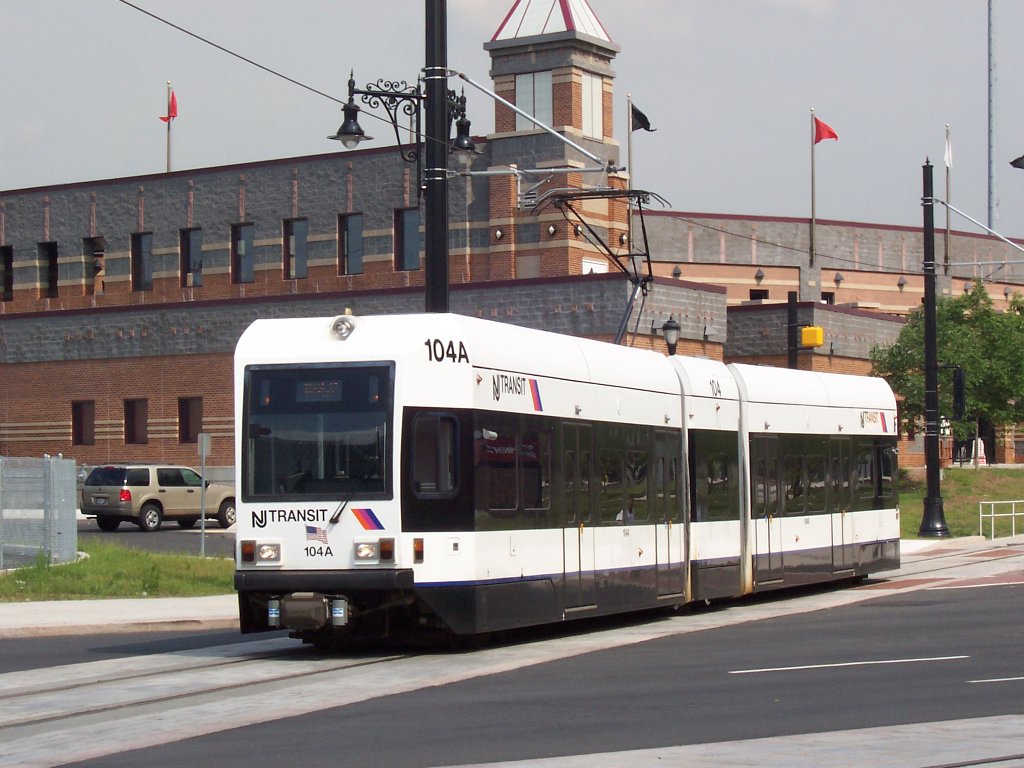
The Modern Line
Today the Newark Light Rail runs 5.3 miles between Newark Penn Station and Grove Street in Bloomfield, making twelve stops. The combined system — NCS and the Broad Street extension — was formally inaugurated as the unified Newark Light Rail on July 17, 2006. NJ Transit owns the line and its bus operations division runs it, a legacy of the days when the City Subway was numbered as a bus route: the #7-City Subway line. That numbering anomaly reflected a bureaucratic reality that persisted long after the infrastructure had ceased to resemble anything like a bus. The trains now are modern low-floor vehicles, a different world from the PCC streetcars that served the line for decades. When the last PCC car made its final run in 2001, transit enthusiasts turned out to say goodbye to rolling stock that dated from an era when Newark still had a full streetcar network.
Threads of Time
What makes the Newark Light Rail unusual isn't its ridership numbers or its network size — both are modest compared to the PATH or the subway across the river. What's unusual is the density of history compressed into its route. In a single 5-mile trip, you travel over a filled canal, through Art Deco tunnels decorated with images of the canal you're traveling over, past neighborhoods that rose and fell with the industrial economy those canals and railroads served, and into suburbs that only became commuter territory when rail made the commute possible. The line runs through the city's university district, past the old Essex County Jail, alongside Branch Brook Park's cherry blossom groves — all of Newark's competing histories within walking distance of the tracks. A transit line, it turns out, is also a kind of timeline.
From the Air
Coordinates: 40.7353°N, 74.185°W. The Newark Light Rail corridor is best viewed from low altitude on approach to Newark Liberty International Airport (KEWR), which lies just south of the system's southern terminus. At 2,000-3,000 feet, the underground-to-surface transition near Warren Street is visible as the line emerges into the urban grid. Branch Brook Park, the largest cherry blossom grove in the United States, sits along the northern portion of the line and is unmistakable from the air in spring.